Enable Location

We need your location to show you interesting places around you

Discover nearby places

Find interesting locations and hidden gems around you

Precise directions

Get accurate directions and distances to places

Your location is never shared with other users. It's only used when you tap the location button.

Northfield Falls Covered Bridge

Log in to your account

Start exploring — it's free

Trusted by 61,364 travelers worldwide

Continue with Google
Continue with Apple
or

We will send you a code to connect

By continuing, you accept our Terms and Conditions and our Privacy Policy

Check your inbox

We've sent a pincode in your inbox. Please enter the code below.

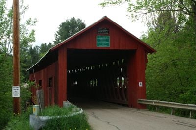
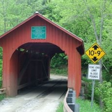
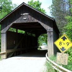
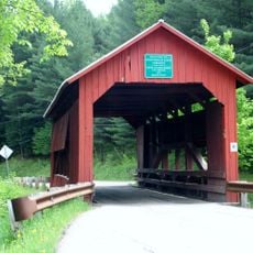
Northfield Falls Covered Bridge, Covered bridge in Northfield, United States.

Description

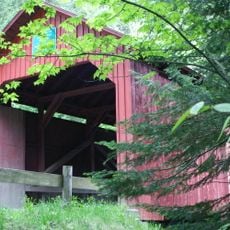
Northfield Falls Covered Bridge is a wooden structure that crosses the Dog River with painted red walls and a metal roof sheltering the roadway. The bridge spans roughly 137 feet and accommodates a single lane that is about 16 feet wide.

History

The bridge was built in 1872 using a Town lattice truss design, a wooden technique common to this region at that time. Nearly a century later, in 1974, it was recognized as a historic place worthy of official protection.

Culture

The bridge is one of five wooden crossings in the town, showing how locals built structures to connect their communities across the river. The red paint and wooden design reflect building methods that were typical in this region generations ago.

Practical

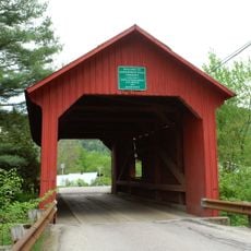
The crossing remains passable for vehicles, though internal reinforcement was added to keep the structure safe over time. Best visited during daylight to see the construction details and the river setting clearly.

Did you know?

From this location, you can see two of these wooden bridges at the same time: the main structure here and the Lower Cox Brook Covered Bridge nearby, which spans a different section of water. This rare side-by-side view of two historic crossings makes the spot especially rewarding for those interested in bridge construction.

Location
GPS coordinates
44.17250,-72.65111
Latest update
December 14, 2025 14:26

AroundUs brings together thousands of curated places, local tips, and hidden gems, enriched daily by 60,000 contributors worldwide. Discover all places nearby (Northfield).

Around this place
Vermont State House
United States of America

Vermont State House

11.5 km
The Pavilion
United States of America

The Pavilion

11.4 km
Socialist Labor Party Hall
United States of America

Socialist Labor Party Hall

11.8 km
Christ Episcopal Church
United States of America

Christ Episcopal Church

11.5 km
Saint Augustine Church, Montpelier
United States of America

Saint Augustine Church, Montpelier

11.3 km
Vermont Granite Museum
United States of America

Vermont Granite Museum

11.3 km
Montpelier City Hall
United States of America

Montpelier City Hall

11.4 km
Athenwood and the Thomas W. Wood Studio
United States of America

Athenwood and the Thomas W. Wood Studio

10.9 km
Slaughter House Covered Bridge
United States of America

Slaughter House Covered Bridge

535 m
Pine Brook Covered Bridge
United States of America

Pine Brook Covered Bridge

11.8 km
Montpelier Historic District
United States of America

Montpelier Historic District

11.5 km
College Hall
United States of America

College Hall

11.4 km
National Clothespin Factory
United States of America

National Clothespin Factory

10.9 km
Stony Brook Covered Bridge
United States of America

Stony Brook Covered Bridge

6.6 km
Lower Cox Brook Covered Bridge
United States of America

Lower Cox Brook Covered Bridge

115 m
Barre City Hall and Opera House
United States of America

Barre City Hall and Opera House

12.1 km
Lover's Lane Bridge
United States of America

Lover's Lane Bridge

2.1 km
Union Co-operative Store Bakery
United States of America

Union Co-operative Store Bakery

11.8 km
Upper Cox Brook Covered Bridge
United States of America

Upper Cox Brook Covered Bridge

355 m
E. L. Smith Roundhouse Granite Shed
United States of America

E. L. Smith Roundhouse Granite Shed

12 km
Beck and Beck Granite Shed
United States of America

Beck and Beck Granite Shed

11.9 km
Brown Public Library
United States of America

Brown Public Library

2.8 km
Mayo Building
United States of America

Mayo Building

2.7 km
Old Red Mill
United States of America

Old Red Mill

6 km
Joshua Twing Gristmill
United States of America

Joshua Twing Gristmill

11.7 km
Chauncey B. Leonard House
United States of America

Chauncey B. Leonard House

7.1 km
Waitsfield Common Historic District
United States of America

Waitsfield Common Historic District

11.7 km
Capitol Theatre
United States of America

Capitol Theatre

11.4 km
Show the full map
« Northfield Falls Covered Bridge - Covered bridge in Northfield, United States » is provided by Around Us (aroundus.com). Images and texts are derived from Wikimedia project under a Creative Commons license. You are allowed to copy, distribute, and modify copies of this page, under the conditions set by the license, as long as this note is clearly visible.

Discover hidden gems everywhere you go!

From secret cafés to breathtaking viewpoints, skip the crowded tourist spots and find places that match your style. Our app makes it easy with voice search, smart filtering, route optimization, and insider tips from travelers worldwide. Download now for the complete mobile experience.

Around Us App Screenshot

A unique approach to discovering new places

Le Figaro

All the places worth exploring

France Info

A tailor-made excursion in just a few clicks

20 Minutes

Around Us
Travel Guide & Maps
Download

Send to your phone

QR Code
1

Open the camera app on your mobile.

2

Point at the QR code with your camera. A notification will appear.

3

Tap the notification to open the link.