Slaughter House Covered Bridge

Log in to your account

AroundUs is a community-driven map of interesting places, built by curious explorers like you. It grows with every review, story, and photo you share.
Connect to save your favorite spots, contribute locations, and create personalized routes.
Continue with Google
Continue with Apple
Continue with X
Continue with Facebook
Continue with email
By continuing, you accept our Terms and Conditions and our Privacy Policy
Create an account
Add to collection
Map
Suggest a change
Share

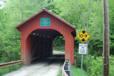
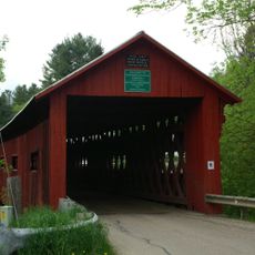
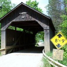
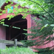
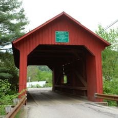
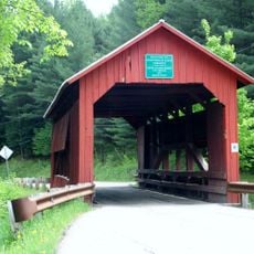
Slaughter House Covered Bridge, Covered bridge in Northfield, United States.

The Slaughter House Covered Bridge crosses the Dog River with a wooden structure featuring vertical board siding along its sides. The truss system uses a Queen post design supported by stone abutments, while the entrance portals have rounded openings with reverse ogee shaped gable ends.

The bridge was constructed in 1872 using established building methods of that decade. It received official recognition through its listing on the National Register of Historic Places in 1974.

The bridge displays traditional construction methods that were common in Vermont at the time it was built. Visitors can observe the carefully crafted stone foundations and wooden framework that reflect the building practices of that era.

The bridge is located west of Vermont Route 12 and remains open to vehicle traffic, though it has an 8-ton weight limit for safety. The roadway is narrow at about 11.75 feet (3.5 meters) wide, requiring careful passage through the covered structure.

The structure features rounded portals at its entrance that visitors often miss when passing through quickly. It belongs to a small group of five surviving covered bridges from the 1800s in the Northfield area.

Location: Northfield

GPS coordinates: 44.16833,-72.65444

Latest update: December 14, 2025 18:07

Photos
Around this place
Vermont State House
United States of America

Vermont State House

12 km
The Pavilion
United States of America

The Pavilion

11.9 km
Socialist Labor Party Hall
United States of America

Socialist Labor Party Hall

12.2 km
Christ Episcopal Church
United States of America

Christ Episcopal Church

12 km
Saint Augustine Church, Montpelier
United States of America

Saint Augustine Church, Montpelier

11.8 km
Northfield Falls Covered Bridge
United States of America

Northfield Falls Covered Bridge

535 m
Vermont Granite Museum
United States of America

Vermont Granite Museum

11.7 km
Montpelier City Hall
United States of America

Montpelier City Hall

11.9 km
Athenwood and the Thomas W. Wood Studio
United States of America

Athenwood and the Thomas W. Wood Studio

11.4 km
Pine Brook Covered Bridge
United States of America

Pine Brook Covered Bridge

11.7 km
Montpelier Historic District
United States of America

Montpelier Historic District

12.1 km
College Hall
United States of America

College Hall

11.9 km
National Clothespin Factory
United States of America

National Clothespin Factory

11.5 km
Stony Brook Covered Bridge
United States of America

Stony Brook Covered Bridge

6 km
Lower Cox Brook Covered Bridge
United States of America

Lower Cox Brook Covered Bridge

519 m
Lover's Lane Bridge
United States of America

Lover's Lane Bridge

2.6 km
Union Co-operative Store Bakery
United States of America

Union Co-operative Store Bakery

12.2 km
Upper Cox Brook Covered Bridge
United States of America

Upper Cox Brook Covered Bridge

591 m
E. L. Smith Roundhouse Granite Shed
United States of America

E. L. Smith Roundhouse Granite Shed

12.3 km
Mad River Valley Rural Historic District
United States of America

Mad River Valley Rural Historic District

12.4 km
Beck and Beck Granite Shed
United States of America

Beck and Beck Granite Shed

12.3 km
Brown Public Library
United States of America

Brown Public Library

2.3 km
Mayo Building
United States of America

Mayo Building

2.2 km
Old Red Mill
United States of America

Old Red Mill

5.5 km
Joshua Twing Gristmill
United States of America

Joshua Twing Gristmill

12.1 km
Chauncey B. Leonard House
United States of America

Chauncey B. Leonard House

7.6 km
Waitsfield Common Historic District
United States of America

Waitsfield Common Historic District

11.5 km
Capitol Theatre
United States of America

Capitol Theatre

12 km
Show the full map
Reviews

Visited this place? Tap the stars to rate it and share your experience / photos with the community! Try now! You can cancel it anytime.

« Slaughter House Covered Bridge - Covered bridge in Northfield, United States » is provided by Around Us (aroundus.com). Images and texts are derived from Wikimedia project under a Creative Commons license. You are allowed to copy, distribute, and modify copies of this page, under the conditions set by the license, as long as this note is clearly visible.

Discover hidden gems everywhere you go!

From secret cafés to breathtaking viewpoints, skip the crowded tourist spots and find places that match your style. Our app makes it easy with voice search, smart filtering, route optimization, and insider tips from travelers worldwide. Download now for the complete mobile experience.

Around Us App Screenshot

A unique approach to discovering new places

Le Figaro

All the places worth exploring

France Info

A tailor-made excursion in just a few clicks

20 Minutes