Enable Location

We need your location to show you interesting places around you

Discover nearby places

Find interesting locations and hidden gems around you

Precise directions

Get accurate directions and distances to places

Your location is never shared with other users. It's only used when you tap the location button.

Occoquan Reservoir

Log in to your account

Start exploring — it's free

Trusted by 62,423 travelers worldwide

Continue with Google
Continue with Apple
or

We will send you a code to connect

By continuing, you accept our Terms and Conditions and our Privacy Policy

Check your inbox

We've sent a pincode in your inbox. Please enter the code below.

Occoquan Reservoir

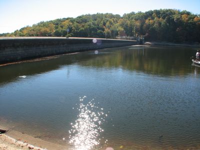
Occoquan Reservoir, body of water

Occoquan Reservoir is a large body of water in Virginia that stretches across more than 2,000 acres near the town of Occoquan. It is managed by the Fairfax Water Authority for water supply while serving recreation, with three marinas where visitors can rent boats, launch them, and access fishing supplies.

The reservoir was created several decades ago by damming the Occoquan River to secure water supply for nearby communities. Since the early 1960s, fish species have been managed and stocked, transforming it into a cornerstone of local infrastructure and recreation.

The reservoir brings together anglers, boaters, and families who gather to spend time outdoors and enjoy the water together. It has become a regular meeting place for locals seeking simple recreational activities and moments of connection with nature away from crowded urban areas.

Visitors can reach the reservoir easily via Route 123 or nearby roads to Fountainhead Park and Bull Run Marina, where parking and boat launches are available. There are no food services or lodging directly at the site, so it is wise to prepare beforehand and check with local authorities for hours and fishing regulations.

The reservoir holds a notable record with a flathead catfish weighing over 66 pounds, one of the largest ever caught in Virginia, showcasing exceptional conditions for growing massive fish. This makes it a destination for anglers seeking rare and sizeable catches that few other places in the region can match.

The community of curious travelers

AroundUs brings together thousands of curated places, local tips, and hidden gems, enriched daily by 60,000 contributors worldwide.

Start exploring
Location
GPS coordinates
38.69420,-77.27640
Latest update
February 7, 2026 11:40
Around this place
Lorton Reformatory
United States of America

Lorton Reformatory

1.9 km
Bel Air
United States of America

Bel Air

9.6 km
Burke Lake
United States of America

Burke Lake

7 km
Burke Lake Park
United States of America

Burke Lake Park

7 km
Fountainhead Regional Park
United States of America

Fountainhead Regional Park

5.4 km
Hemlock Overlook Regional Park
United States of America

Hemlock Overlook Regional Park

14.3 km
Workhouse Arts Center
United States of America

Workhouse Arts Center

1.9 km
Ekoji Buddhist Temple
United States of America

Ekoji Buddhist Temple

9.1 km
St. Mary's Church
United States of America

St. Mary's Church

12.8 km
Old Town Manassas
United States of America

Old Town Manassas

18.1 km
"A" Fort and Battery Hill Redoubt-Camp Early
United States of America

"A" Fort and Battery Hill Redoubt-Camp Early

16.9 km
Durga Temple of Virginia
United States of America

Durga Temple of Virginia

4.4 km
Rockledge
United States of America

Rockledge

1.6 km
Occoquan Regional Park
United States of America

Occoquan Regional Park

2.4 km
C.D. Hylton Senior High School
United States of America

C.D. Hylton Senior High School

10.6 km
Occoquan Historic District
United States of America

Occoquan Historic District

1.8 km
Conner House
United States of America

Conner House

16.7 km
Signal Hill
United States of America

Signal Hill

15.5 km
Sydenstricker School
United States of America

Sydenstricker School

7.6 km
Manassas Water Tower
United States of America

Manassas Water Tower

18 km
Clifton Historic District
United States of America

Clifton Historic District

13.5 km
Orange and Alexandria Railroad Bridge Piers
United States of America

Orange and Alexandria Railroad Bridge Piers

15.6 km
Atoka Historic District
United States of America

Atoka Historic District

13.5 km
Mayfield Fortification
United States of America

Mayfield Fortification

16.6 km
Odd Fellows Hall
United States of America

Odd Fellows Hall

1.7 km
Hope Park Mill and Miller's House Robey's Mill
United States of America

Hope Park Mill and Miller's House Robey's Mill

15.5 km
Lorton Community Library
United States of America

Lorton Community Library

5.5 km
Burke Centre Community Library
United States of America

Burke Centre Community Library

11.1 km
Show the full map
« Occoquan Reservoir - body of water » is provided by Around Us (aroundus.com). Images and texts are derived from Wikimedia project under a Creative Commons license. You are allowed to copy, distribute, and modify copies of this page, under the conditions set by the license, as long as this note is clearly visible.

Discover hidden gems everywhere you go!

From secret cafés to breathtaking viewpoints, skip the crowded tourist spots and find places that match your style. Our app makes it easy with voice search, smart filtering, route optimization, and insider tips from travelers worldwide. Download now for the complete mobile experience.

Around Us App Screenshot

A unique approach to discovering new places

Le Figaro

All the places worth exploring

France Info

A tailor-made excursion in just a few clicks

20 Minutes

Around Us
Travel Guide & Maps
Download

Send to your phone

QR Code
1

Open the camera app on your mobile.

2

Point at the QR code with your camera. A notification will appear.

3

Tap the notification to open the link.