Signal Hill

Log in to your account

AroundUs is a community-driven map of interesting places, built by curious explorers like you. It grows with every review, story, and photo you share.
Connect to save your favorite spots, contribute locations, and create personalized routes.
By continuing, you accept our Terms and Conditions and our Privacy Policy
Add to collection
Map
Suggest a change
Share

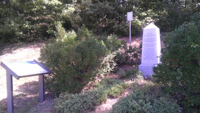
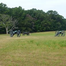
Signal Hill, Civil War observation point in Prince William County, Virginia

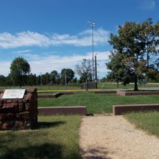
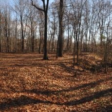
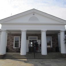
Signal Hill is a Civil War observation point in Prince William County that sits at a high elevation providing views across the surrounding landscape. The site features maintained walking paths leading to the summit and interpretive displays that explain its military significance.

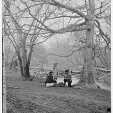
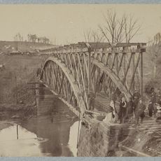
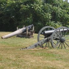
Confederate soldiers stationed here in 1861 to monitor Union Army movements at nearby Sudley Ford during the lead-up to the First Battle of Bull Run. This elevated position was crucial to Confederate defense strategy in northern Virginia.

The site connects visitors to how Civil War soldiers relied on high ground to watch enemy movements and coordinate their forces. Today, people can stand in the same spot and understand the strategic thinking behind military positioning.

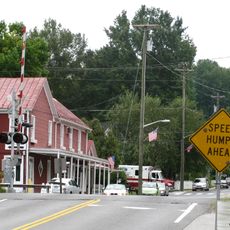
Access the site via Signal View Road, where signs guide you to parking and the main park area. Wear comfortable shoes for walking the hillside paths, as the terrain is uneven and the highest viewing points require some climbing.

A neighborhood association manages the preservation of the hilltop alongside the public park, combining community stewardship with visitor access. This dual approach means the site maintains both its historical integrity and recreational appeal.

GPS coordinates: 38.75140,-77.43860

Latest update: December 14, 2025 18:01

Photos
Around this place
Centreville High School
United States of America

Centreville High School

8.6 km
Henry House
United States of America

Henry House

10.2 km
Splash Down Waterpark
United States of America

Splash Down Waterpark

5.8 km
Hemlock Overlook Regional Park
United States of America

Hemlock Overlook Regional Park

3.3 km
Stone Bridge
United States of America

Stone Bridge

9.9 km
Robinson House
United States of America

Robinson House

10.3 km
Old Town Manassas
United States of America

Old Town Manassas

2.8 km
"A" Fort and Battery Hill Redoubt-Camp Early
United States of America

"A" Fort and Battery Hill Redoubt-Camp Early

4.3 km
Manassas Industrial School for Colored Youth
United States of America

Manassas Industrial School for Colored Youth

4.5 km
Culpeper Basin
United States of America

Culpeper Basin

8.2 km
Blackburn's Ford
United States of America

Blackburn's Ford

5.8 km
Prince William County Courthouse
United States of America

Prince William County Courthouse

3.3 km
Conner House
United States of America

Conner House

1.7 km
Moor Green
United States of America

Moor Green

7.1 km
Cannon Branch Fort
United States of America

Cannon Branch Fort

7 km
Brentsville Courthouse and Jail
United States of America

Brentsville Courthouse and Jail

8.7 km
Manassas Water Tower
United States of America

Manassas Water Tower

2.7 km
White House
United States of America

White House

8.8 km
Brentsville Historic District
United States of America

Brentsville Historic District

8.8 km
Clifton Historic District
United States of America

Clifton Historic District

5.5 km
Orange and Alexandria Railroad Bridge Piers
United States of America

Orange and Alexandria Railroad Bridge Piers

3.2 km
Atoka Historic District
United States of America

Atoka Historic District

5.5 km
Mayfield Fortification
United States of America

Mayfield Fortification

1.2 km
Davis-Beard House
United States of America

Davis-Beard House

9.1 km
Henry Hill Visitor Center
United States of America

Henry Hill Visitor Center

10 km
Henry Hill
United States of America

Henry Hill

10.1 km
Centreville Regional Library
United States of America

Centreville Regional Library

9.6 km
Hope Park Mill and Miller's House Robey's Mill
United States of America

Hope Park Mill and Miller's House Robey's Mill

9.4 km
Show the full map
Reviews

Visited this place? Tap the stars to rate it and share your experience / photos with the community! Try now! You can cancel it anytime.

« Signal Hill - Civil War observation point in Prince William County, Virginia » is provided by Around Us (aroundus.com). Images and texts are derived from Wikimedia project under a Creative Commons license. You are allowed to copy, distribute, and modify copies of this page, under the conditions set by the license, as long as this note is clearly visible.

Discover hidden gems everywhere you go!

From secret cafés to breathtaking viewpoints, skip the crowded tourist spots and find places that match your style. Our app makes it easy with voice search, smart filtering, route optimization, and insider tips from travelers worldwide. Download now for the complete mobile experience.

Around Us App Screenshot

A unique approach to discovering new places

Le Figaro

All the places worth exploring

France Info

A tailor-made excursion in just a few clicks

20 Minutes