Enable Location

We need your location to show you interesting places around you

Discover nearby places

Find interesting locations and hidden gems around you

Precise directions

Get accurate directions and distances to places

Your location is never shared with other users. It's only used when you tap the location button.

Oriskany Battlefield State Historic Site

Log in to your account

Start exploring — it's free

Trusted by 62,461 travelers worldwide

Continue with Google
Continue with Apple
or

We will send you a code to connect

By continuing, you accept our Terms and Conditions and our Privacy Policy

Check your inbox

We've sent a pincode in your inbox. Please enter the code below.

Oriskany Battlefield State Historic Site, Revolutionary War battlefield in Oriskany, New York.

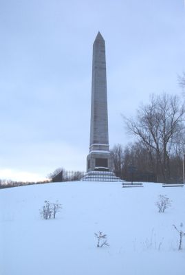
Oriskany Battlefield State Historic Site is a Revolutionary War battlefield in New York situated near the Mohawk River. The grounds contain elevated terrain with ravines, walking paths, and a central obelisk memorial along with interpretive displays that guide visitors through the historic ground.

The battlefield formed from a 1777 military engagement when militia members under General Nicholas Herkimer clashed with British, Loyalist, and Indigenous forces during the Revolutionary War. The combat became notable for its extremely high casualty count and marked a turning point in the struggle for regional control.

The site marks divisions within Indigenous communities during the Revolutionary period, as visitors explore monuments and learn how families faced opposing allegiances. The landscape reflects these internal conflicts through the placement of memorials and interpretive markers scattered across the grounds.

The site is best explored on foot, with the option to walk the wooded paths independently or join guided tours led by interpreters. Visitors should prepare for variable weather and wear comfortable shoes as the terrain has slopes and uneven ground throughout.

The battlefield hosted one of the war's deadliest engagements, with casualty rates that far exceeded other Revolutionary combat. This extreme intensity arose from the brutal conditions of the ambush, where fighters developed improvised survival tactics.

The community of curious travelers

AroundUs brings together thousands of curated places, local tips, and hidden gems, enriched daily by 60,000 contributors worldwide.

Start exploring
Location
Operator
New York State Office of Parks, Recreation and Historic Preservation
GPS coordinates
43.17730,-75.36950
Latest update
December 9, 2025 18:46
Around this place
Fort Stanwix
United States of America

Fort Stanwix

7.9 km
Utica Psychiatric Center
United States of America

Utica Psychiatric Center

12.4 km
Munson
United States of America

Munson

13.7 km
Stanley Theater
United States of America

Stanley Theater

13.9 km
Delta Lake
United States of America

Delta Lake

13.6 km
Delta Lake State Park
United States of America

Delta Lake State Park

13.3 km
Clinton Arena
United States of America

Clinton Arena

13.8 km
Utica Public Library
United States of America

Utica Public Library

13.9 km
Grace Church
United States of America

Grace Church

14.1 km
Fountain Elms
United States of America

Fountain Elms

13.7 km
Fort Schuyler Club Building
United States of America

Fort Schuyler Club Building

13.9 km
Doyle Hardware Building
United States of America

Doyle Hardware Building

14.4 km
Alexander Pirnie Federal Building
United States of America

Alexander Pirnie Federal Building

14.1 km
New Century Club
United States of America

New Century Club

13.9 km
Rome Arsenal
United States of America

Rome Arsenal

9 km
Globe Woolen Company Mills
United States of America

Globe Woolen Company Mills

12.9 km
United States of America

Zion Church

8.2 km
Jervis Public Library
United States of America

Jervis Public Library

8.3 km
Utica Daily Press Building
United States of America

Utica Daily Press Building

14.3 km
Millar-Wheeler House
United States of America

Millar-Wheeler House

13.7 km
Gansevoort-Bellamy Historic District
United States of America

Gansevoort-Bellamy Historic District

8.1 km
United States of America

St. Mark's Church

9.7 km
Holland Patent Stone Churches Historic District
United States of America

Holland Patent Stone Churches Historic District

11.6 km
Litchfield Observatory
United States of America

Litchfield Observatory

14.1 km
Mills House (Rome, New York)
United States of America

Mills House (Rome, New York)

8.5 km
Whitestown Town Hall
United States of America

Whitestown Town Hall

8.9 km
First Methodist Episcopal Church of Rome
United States of America

First Methodist Episcopal Church of Rome

8.4 km
Peterpaul Recreation Park
United States of America

Peterpaul Recreation Park

13.2 km
Show the full map
« Oriskany Battlefield State Historic Site - Revolutionary War battlefield in Oriskany, New York » is provided by Around Us (aroundus.com). Images and texts are derived from Wikimedia project under a Creative Commons license. You are allowed to copy, distribute, and modify copies of this page, under the conditions set by the license, as long as this note is clearly visible.

Discover hidden gems everywhere you go!

From secret cafés to breathtaking viewpoints, skip the crowded tourist spots and find places that match your style. Our app makes it easy with voice search, smart filtering, route optimization, and insider tips from travelers worldwide. Download now for the complete mobile experience.

Around Us App Screenshot

A unique approach to discovering new places

Le Figaro

All the places worth exploring

France Info

A tailor-made excursion in just a few clicks

20 Minutes

Around Us
Travel Guide & Maps
Download

Send to your phone

QR Code
1

Open the camera app on your mobile.

2

Point at the QR code with your camera. A notification will appear.

3

Tap the notification to open the link.