Enable Location

We need your location to show you interesting places around you

Discover nearby places

Find interesting locations and hidden gems around you

Precise directions

Get accurate directions and distances to places

Your location is never shared with other users. It's only used when you tap the location button.

Olney High School

Log in to your account

Start exploring — it's free

Trusted by 62,304 travelers worldwide

Continue with Google
Continue with Apple
or

We will send you a code to connect

By continuing, you accept our Terms and Conditions and our Privacy Policy

Check your inbox

We've sent a pincode in your inbox. Please enter the code below.

Olney High School, high school in Philadelphia

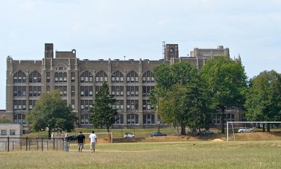
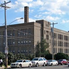
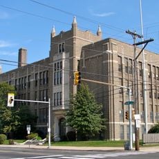
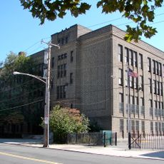
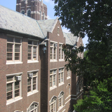
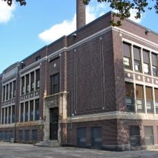
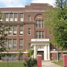
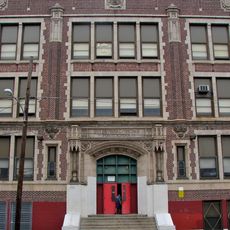
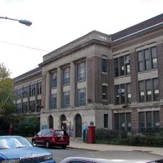
Olney High School is a public high school in Philadelphia completed in 1930 and distinguished by its five-story brick facade with limestone details. The building features Gothic-inspired elements such as pointed arches and is dominated by a distinctive tower set on a granite base.

The school was designed by architect Irwin T. Catharine in the late 1920s and completed in 1930 to meet the educational needs of the growing city. In December 1986, it was added to the National Register of Historic Places, recognizing its significance as a historic and architectural landmark.

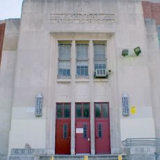
The school bears the name of the neighborhood where it stands and serves as an anchor point for the local community. Its building with tall arches and limestone details reflects the importance placed on durability and dignity for public education in the early 20th century.

The building is located on West Duncannon Avenue in the Olney neighborhood and is easy to spot due to its distinctive tower and large brick facade. The site is accessible by public transit or on foot and sits centrally in a residential area with local shops and homes.

The school was temporarily divided into two separate facilities called Olney East and Olney West before being reunited. Notable alumni include writer Clair Blank, who authored the Beverly Gray mystery series, along with graduates who pursued careers in music, sports, and local politics.

The community of curious travelers

AroundUs brings together thousands of curated places, local tips, and hidden gems, enriched daily by 60,000 contributors worldwide.

Start exploring
Location
GPS coordinates
40.02750,-75.12360
Latest update
February 7, 2026 11:01
Around this place
Central High School
United States of America

Central High School

1.7 km
Friends Hospital
United States of America

Friends Hospital

2 km
Tom Gola Arena
United States of America

Tom Gola Arena

3.1 km
Stenton
United States of America

Stenton

2.7 km
Belfield
United States of America

Belfield

3 km
Carl Mackley Houses
United States of America

Carl Mackley Houses

2.7 km
McCarthy Stadium
United States of America

McCarthy Stadium

2.8 km
Upsala
United States of America

Upsala

2.4 km
Thomas K. Finletter School
United States of America

Thomas K. Finletter School

1.8 km
Adams Avenue Bridge
United States of America

Adams Avenue Bridge

1.8 km
Alexander K. McClure School
United States of America

Alexander K. McClure School

1.9 km
Olney Elementary School
United States of America

Olney Elementary School

603 m
Bayard Taylor School
United States of America

Bayard Taylor School

2.6 km
Andrew J. Morrison School
United States of America

Andrew J. Morrison School

585 m
Henry S. Frank Memorial Synagogue
United States of America

Henry S. Frank Memorial Synagogue

2 km
Universal Creighton Charter School
United States of America

Universal Creighton Charter School

1.6 km
Francis Hopkinson School
United States of America

Francis Hopkinson School

2.8 km
College Hall
United States of America

College Hall

2.9 km
Benjamin Franklin Academics Plus School
United States of America

Benjamin Franklin Academics Plus School

2.3 km
James Logan Elementary School
United States of America

James Logan Elementary School

2.5 km
Julia Ward Howe School
United States of America

Julia Ward Howe School

2.2 km
Joseph Pennell School
United States of America

Joseph Pennell School

2.9 km
Suffolk Manor Apartments
United States of America

Suffolk Manor Apartments

2.3 km
Gen. David B. Birney School
United States of America

Gen. David B. Birney School

1.3 km
Special Troops Armory
United States of America

Special Troops Armory

2.5 km
Feltonville School No. 2
United States of America

Feltonville School No. 2

348 m
Fisher's Lane Bridge
United States of America

Fisher's Lane Bridge

1.9 km
Jay Cooke Junior High School
United States of America

Jay Cooke Junior High School

2 km
Show the full map
« Olney High School - high school in Philadelphia » is provided by Around Us (aroundus.com). Images and texts are derived from Wikimedia project under a Creative Commons license. You are allowed to copy, distribute, and modify copies of this page, under the conditions set by the license, as long as this note is clearly visible.

Discover hidden gems everywhere you go!

From secret cafés to breathtaking viewpoints, skip the crowded tourist spots and find places that match your style. Our app makes it easy with voice search, smart filtering, route optimization, and insider tips from travelers worldwide. Download now for the complete mobile experience.

Around Us App Screenshot

A unique approach to discovering new places

Le Figaro

All the places worth exploring

France Info

A tailor-made excursion in just a few clicks

20 Minutes

Around Us
Travel Guide & Maps
Download

Send to your phone

QR Code
1

Open the camera app on your mobile.

2

Point at the QR code with your camera. A notification will appear.

3

Tap the notification to open the link.