·

Enable Location

We need your location to show you interesting places around you

Discover nearby places

Find interesting locations and hidden gems around you

Precise directions

Get accurate directions and distances to places

Your location is never shared with other users. It's only used when you tap the location button.

Adams Avenue Bridge

Log in to your account

Start exploring — it's free

Trusted by 62,714 travelers worldwide

Continue with Google
Continue with Apple
or

We will send you a code to connect

By continuing, you accept our Terms and Conditions and our Privacy Policy

Check your inbox

We've sent a pincode in your inbox. Please enter the code below.

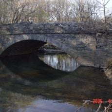
Adams Avenue Bridge, Stone arch bridge in Philadelphia, United States.

Adams Avenue Bridge is a stone arch bridge with three spans that crosses Tacony Creek in Philadelphia. The structure carries vehicle traffic and connects different parts of the city while situated near the waterway and surrounding parkland.

The bridge was built in 1901 to connect different parts of Philadelphia across Tacony Creek. The structure was added to the National Register of Historic Places in 1988.

The bridge shows construction methods typical of early 20th-century Philadelphia, reflecting local engineering standards of the era. Its stone arch design remains a visible example of how builders approached transportation infrastructure at that time.

The bridge is a functioning road crossing open to both pedestrians and vehicles during normal hours. You can walk or drive across it as part of visiting the area around Tacony Creek Park.

The bridge is a relatively overlooked example of early American stone arch construction despite being used daily by many people. Its recognition in the historic register reveals how local infrastructure from this era matters to architectural history.

The community of curious travelers

AroundUs brings together thousands of curated places, local tips, and hidden gems, enriched daily by 60,000 contributors worldwide.

Start exploring
Location
Inception
1901
Made from material
stone
GPS coordinates
40.04194,-75.11333
Latest update
December 14, 2025 12:20
Around this place
Central High School
United States of America

Central High School

2.2 km
Friends Hospital
United States of America

Friends Hospital

2.1 km
Olney High School
United States of America

Olney High School

1.8 km
Old Trinity Church
United States of America

Old Trinity Church

2.7 km
McCarthy Stadium
United States of America

McCarthy Stadium

3.5 km
Upsala
United States of America

Upsala

2 km
Thomas K. Finletter School
United States of America

Thomas K. Finletter School

553 m
Rowland House
United States of America

Rowland House

2.4 km
Gen. Louis Wagner Junior High School
United States of America

Gen. Louis Wagner Junior High School

3.1 km
Cedar Grove Christian Academy
United States of America

Cedar Grove Christian Academy

2 km
Olney Elementary School
United States of America

Olney Elementary School

1.3 km
Andrew J. Morrison School
United States of America

Andrew J. Morrison School

2 km
Philadelphia Charter School for Arts and Sciences
United States of America

Philadelphia Charter School for Arts and Sciences

2.9 km
Henry S. Frank Memorial Synagogue
United States of America

Henry S. Frank Memorial Synagogue

2.6 km
Kennedy Crossan School
United States of America

Kennedy Crossan School

3.5 km
Universal Creighton Charter School
United States of America

Universal Creighton Charter School

2 km
College Hall
United States of America

College Hall

3.5 km
Benjamin Franklin Academics Plus School
United States of America

Benjamin Franklin Academics Plus School

738 m
Julia Ward Howe School
United States of America

Julia Ward Howe School

2.5 km
Joseph Pennell School
United States of America

Joseph Pennell School

3.2 km
Suffolk Manor Apartments
United States of America

Suffolk Manor Apartments

2.7 km
Gen. David B. Birney School
United States of America

Gen. David B. Birney School

2.6 km
Special Troops Armory
United States of America

Special Troops Armory

3.3 km
Feltonville School No. 2
United States of America

Feltonville School No. 2

2.1 km
Fisher's Lane Bridge
United States of America

Fisher's Lane Bridge

2.5 km
Jay Cooke Junior High School
United States of America

Jay Cooke Junior High School

3.4 km
George K. Heller School
United States of America

George K. Heller School

2.7 km
Laura H. Carnell School
United States of America

Laura H. Carnell School

2.5 km
Show the full map
« Adams Avenue Bridge - Stone arch bridge in Philadelphia, United States » is provided by Around Us (aroundus.com). Images and texts are derived from Wikimedia project under a Creative Commons license. You are allowed to copy, distribute, and modify copies of this page, under the conditions set by the license, as long as this note is clearly visible.

Discover hidden gems everywhere you go!

From secret cafés to breathtaking viewpoints, skip the crowded tourist spots and find places that match your style. Our app makes it easy with voice search, smart filtering, route optimization, and insider tips from travelers worldwide. Download now for the complete mobile experience.

Around Us App Screenshot

A unique approach to discovering new places

Le Figaro

All the places worth exploring

France Info

A tailor-made excursion in just a few clicks

20 Minutes

Around Us
Travel Guide & Maps
Download

Send to your phone

QR Code
1

Open the camera app on your mobile.

2

Point at the QR code with your camera. A notification will appear.

3

Tap the notification to open the link.