Enable Location

We need your location to show you interesting places around you

Discover nearby places

Find interesting locations and hidden gems around you

Precise directions

Get accurate directions and distances to places

Your location is never shared with other users. It's only used when you tap the location button.

Log in to your account

Start exploring — it's free

Trusted by 61,983 travelers worldwide

Continue with Google
Continue with Apple
or

We will send you a code to connect

By continuing, you accept our Terms and Conditions and our Privacy Policy

Check your inbox

We've sent a pincode in your inbox. Please enter the code below.

Paddy Creek Wilderness

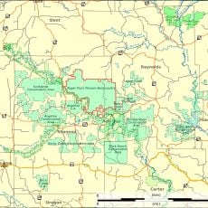
Paddy Creek Wilderness, Wilderness area in Missouri, United States.

Paddy Creek Wilderness is a protected natural area within the Mark Twain National Forest featuring oak-hickory forests, deep valleys, and multiple streams. The landscape provides extensive trail access and open water features throughout the wooded terrain.

Congress officially designated this area as a protected wilderness in 1983, securing long-term preservation of the forest and its natural resources. The designation reflected efforts to maintain unspoiled woodland environments within the national forest system.

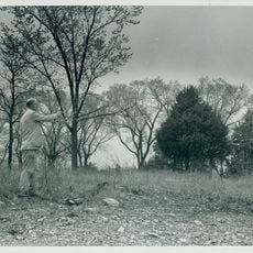
The Big Piney Trail extends for 17 miles through the wilderness, allowing visitors to discover native Missouri plants and wildlife species.

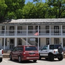
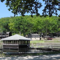
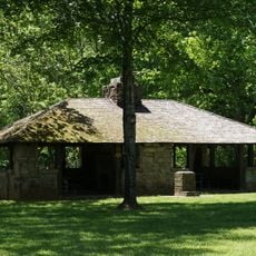
The area offers designated campsites at Paddy Creek Recreation Area with single and double sites available for visitors. Bring sturdy footwear and plenty of water, as the terrain can be uneven and trails wind through forested slopes.

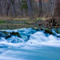
Two creeks, Big Paddy and Little Paddy, intersect within the wilderness boundaries creating multiple fishing opportunities. The waterways form natural features that shape the hiking experience and support different ecosystems.

The community of curious travelers

AroundUs brings together thousands of curated places, local tips, and hidden gems, enriched daily by 60,000 contributors worldwide.

Start exploring
Location
GPS coordinates
37.52110,-92.07390
Latest update
December 12, 2025 14:25
Around this place
Uranus Missouri
United States of America

Uranus Missouri

34.4 km
Laura Ingalls Wilder House
United States of America

Laura Ingalls Wilder House

63.5 km
United States of America

Echo Bluff State Park

63.5 km
United States of America

Marine Corps Detachment, Fort Leonard Wood

24.8 km
Current River State Park
United States of America

Current River State Park

60.5 km
Roger Pryor Pioneer Backcountry
United States of America

Roger Pryor Pioneer Backcountry

60.9 km
Allgood–Bailey Stadium
United States of America

Allgood–Bailey Stadium

54.3 km
Fort Wyman
United States of America

Fort Wyman

53.2 km
Old Stagecoach Stop
United States of America

Old Stagecoach Stop

36.1 km
Ralph E. Burley House
United States of America

Ralph E. Burley House

54.6 km
Laura Ingalls Wilder Historic Home & Museum
United States of America

Laura Ingalls Wilder Historic Home & Museum

64.1 km
Wallace House
United States of America

Wallace House

55 km
Calloway Manes Homestead
United States of America

Calloway Manes Homestead

49.2 km
Ploger-Moneymaker Place
United States of America

Ploger-Moneymaker Place

55.1 km
Rolla Ranger Station Historic District
United States of America

Rolla Ranger Station Historic District

53.3 km
Dent County Courthouse
United States of America

Dent County Courthouse

49.5 km
Phelps County Courthouse
United States of America

Phelps County Courthouse

54.2 km
Alton Club
United States of America

Alton Club

60.5 km
Pulaski County Courthouse
United States of America

Pulaski County Courthouse

36.1 km
St. James Chapel
United States of America

St. James Chapel

66.4 km
Montauk State Park
United States of America

Montauk State Park

35.6 km
Montauk State Park Open Shelter
United States of America

Montauk State Park Open Shelter

35 km
Uranus
United States of America

Uranus

34.4 km
Lower Parker School
United States of America

Lower Parker School

40.8 km
Topaz Mill
United States of America

Topaz Mill

65 km
Maramec Iron Works
United States of America

Maramec Iron Works

67.5 km
Old Mill at Montauk State Park
United States of America

Old Mill at Montauk State Park

35.3 km
Devils Elbow Bridge
United States of America

Devils Elbow Bridge

36.4 km
Show the full map
« Paddy Creek Wilderness - Wilderness area in Missouri, United States » is provided by Around Us (aroundus.com). Images and texts are derived from Wikimedia project under a Creative Commons license. You are allowed to copy, distribute, and modify copies of this page, under the conditions set by the license, as long as this note is clearly visible.

Discover hidden gems everywhere you go!

From secret cafés to breathtaking viewpoints, skip the crowded tourist spots and find places that match your style. Our app makes it easy with voice search, smart filtering, route optimization, and insider tips from travelers worldwide. Download now for the complete mobile experience.

Around Us App Screenshot

A unique approach to discovering new places

Le Figaro

All the places worth exploring

France Info

A tailor-made excursion in just a few clicks

20 Minutes

Around Us
Travel Guide & Maps
Download

Send to your phone

QR Code
1

Open the camera app on your mobile.

2

Point at the QR code with your camera. A notification will appear.

3

Tap the notification to open the link.