Pittsburg–Clarksville Covered Bridge

Log in to your account

AroundUs is a community-driven map of interesting places, built by curious explorers like you. It grows with every review, story, and photo you share.
Connect to save your favorite spots, contribute locations, and create personalized routes.
Continue with Google
Continue with Apple
Continue with X
Continue with Facebook
Continue with email
By continuing, you accept our Terms and Conditions and our Privacy Policy
Create an account

Pittsburg–Clarksville Covered Bridge

Add to collection
Map
Suggest a change
Share

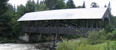
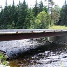
Pittsburg–Clarksville Covered Bridge, Covered bridge across Connecticut River in Pittsburg, United States.

Pittsburg-Clarksville Covered Bridge is a wooden crossing over the Connecticut River between two neighboring communities in northern New Hampshire. The structure features a Paddleford truss system that provides structural support and spans the river at a point where rapids create a dramatic landscape.

The bridge was built in 1876 to connect the two communities separated by the river during an era of active bridge construction across New England. Its survival through more than a century reflects both the durability of its design and the local commitment to preserving it.

The bridge, designated as New Hampshire Covered Bridge Number 34, represents the engineering methods and construction techniques of nineteenth-century American bridge builders.

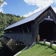
The bridge is open only to pedestrians, making it easy to walk across at your own pace while enjoying views of the river below. The crossing is short and straightforward, giving visitors a chance to observe both the historic structure and the surrounding landscape.

This is the northernmost covered bridge crossing the Connecticut River in the entire state. The specialized Paddleford truss design was an innovative engineering choice for handling the force and flow of the water at this location.

Location: New Hampshire

GPS coordinates: 45.05440,-71.40690

Latest update: December 14, 2025 12:21

Photos
Around this place
Dixville Notch State Park
United States of America

Dixville Notch State Park

23.2 km
Coleman State Park
United States of America

Coleman State Park

13.8 km
United States of America

Beaver Brook Falls Wayside

15.7 km
United States of America

Mount Kelsey

29.1 km
Columbia Bridge
United States of America

Columbia Bridge

25.1 km
Julien Morin Stadium
Canada

Julien Morin Stadium

32.2 km
Montagne des Lignes
Canada

Montagne des Lignes

27.6 km
Saint-Isidore-d'Auckland
Canada

Saint-Isidore-d'Auckland

25.1 km
Indian Stream Schoolhouse
United States of America

Indian Stream Schoolhouse

3.1 km
Alice M. Ward Library
United States of America

Alice M. Ward Library

12.3 km
Wallace Farm
United States of America

Wallace Farm

23 km
Benjamin Aldrich Homestead
United States of America

Benjamin Aldrich Homestead

15.1 km
Église Saint-Herménégilde de Saint-Herménégilde
Canada

Église Saint-Herménégilde de Saint-Herménégilde

21.8 km
Site du patrimoine de l'église de Saint-Venant-de-Paquette
Canada

Site du patrimoine de l'église de Saint-Venant-de-Paquette

9 km
Site du patrimoine du canton de Sainte-Edwidge-de-Clifton
Canada

Site du patrimoine du canton de Sainte-Edwidge-de-Clifton

27.3 km
Secteur Saint-Edmond
Canada

Secteur Saint-Edmond

32 km
Église de Saint-Venant-de-Paquette
Canada

Église de Saint-Venant-de-Paquette

9.2 km
Forest Access Road bridge over the Connecticut River
United States of America

Forest Access Road bridge over the Connecticut River

8.5 km
Scott Brook Road bridge over the Connecticut River
United States of America

Scott Brook Road bridge over the Connecticut River

22.9 km
U.S. Route 3 Bridge over the Connecticut River
United States of America

U.S. Route 3 Bridge over the Connecticut River

22.7 km
Croix de chemin Scalabrini
Canada

Croix de chemin Scalabrini

27.8 km
Stanhope border crossing
Canada

Stanhope border crossing

30.5 km
Croix de chemin Lemire
Canada

Croix de chemin Lemire

27.7 km
Magalloway Road Bridge over the Connecticut River
United States of America

Magalloway Road Bridge over the Connecticut River

17.1 km
Croix de chemin du Village de Saint-Edwidge
Canada

Croix de chemin du Village de Saint-Edwidge

27.2 km
Croix de chemin paroissiale
Canada

Croix de chemin paroissiale

29.6 km
MEC Connecticut River Bridge
United States of America

MEC Connecticut River Bridge

11.4 km
Second Connecticut Lake
United States of America

Second Connecticut Lake

21.6 km
Show the full map
Reviews

Visited this place? Tap the stars to rate it and share your experience / photos with the community! Try now! You can cancel it anytime.

« Pittsburg–Clarksville Covered Bridge - Covered bridge across Connecticut River in Pittsburg, United States » is provided by Around Us (aroundus.com). Images and texts are derived from Wikimedia project under a Creative Commons license. You are allowed to copy, distribute, and modify copies of this page, under the conditions set by the license, as long as this note is clearly visible.

Discover hidden gems everywhere you go!

From secret cafés to breathtaking viewpoints, skip the crowded tourist spots and find places that match your style. Our app makes it easy with voice search, smart filtering, route optimization, and insider tips from travelers worldwide. Download now for the complete mobile experience.

Around Us App Screenshot

A unique approach to discovering new places

Le Figaro

All the places worth exploring

France Info

A tailor-made excursion in just a few clicks

20 Minutes