Enable Location

We need your location to show you interesting places around you

Discover nearby places

Find interesting locations and hidden gems around you

Precise directions

Get accurate directions and distances to places

Your location is never shared with other users. It's only used when you tap the location button.

Portage Lakes

Log in to your account

Start exploring — it's free

Trusted by 62,565 travelers worldwide

Continue with Google
Continue with Apple
or

We will send you a code to connect

By continuing, you accept our Terms and Conditions and our Privacy Policy

Check your inbox

We've sent a pincode in your inbox. Please enter the code below.

Portage Lakes

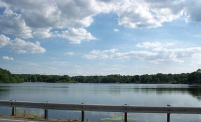
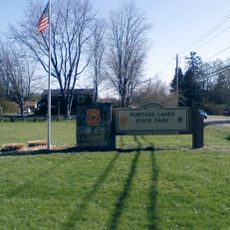
Portage Lakes, group of lakes in Ohio

Portage Lakes is a collection of connected lakes and reservoirs in northeastern Ohio that includes both natural and man-made bodies of water. Eight lakes spread across the area, fed by small streams and supplementary reservoirs, with water flowing in two directions toward Lake Erie and the Ohio River.

The lakes formed partly from ancient glacial activity when melting ice created depressions that filled with water, while others were enlarged later to support the Ohio and Erie Canal system in the 1800s. After the canal was abandoned in 1913, the lakes became water sources for local industries until Ohio took over management in the mid-1900s.

The name Portage Lakes comes from an old path that Native Americans and early settlers used for trade and travel between waterways. Today the lakes remain a gathering place where locals and visitors connect with the water and learn about this historic crossroads role.

The park offers boat ramps at several locations to launch motorized boats, though Turkeyfoot Lake allows only electric motors, and nearby marinas provide boat rentals and fuel. Visitors should check boating restrictions as some lakes permit higher-speed engines only during certain days and times, while others remain quiet waters.

The location sits on a geographic ridge that divides water flow in two opposite directions, with some lakes feeding Lake Erie in the north while others drain toward the Ohio River to the south. This rare feature made the area a critical crossing point for movement and trade across different regions.

The community of curious travelers

AroundUs brings together thousands of curated places, local tips, and hidden gems, enriched daily by 60,000 contributors worldwide.

Start exploring
Location
GPS coordinates
41.00639,-81.52389
Latest update
February 7, 2026 11:01
Around this place
Rubber Bowl
United States of America

Rubber Bowl

6.8 km
Goodyear Airdock
United States of America

Goodyear Airdock

5.3 km
InfoCision Stadium – Summa Field
United States of America

InfoCision Stadium – Summa Field

7.5 km
Akron Civic Theatre
United States of America

Akron Civic Theatre

8.3 km
Akron Zoo
United States of America

Akron Zoo

8.2 km
Goodyear Polymer Center
United States of America

Goodyear Polymer Center

7.9 km
E. J. Thomas Hall
United States of America

E. J. Thomas Hall

8.1 km
Portage Lakes State Park
United States of America

Portage Lakes State Park

5 km
FirstEnergy Stadium-Cub Cadet Field
United States of America

FirstEnergy Stadium-Cub Cadet Field

7.6 km
Goodyear Hall-Ohio Savings and Trust Company
United States of America

Goodyear Hall-Ohio Savings and Trust Company

7.5 km
St. Bernard's Church
United States of America

St. Bernard's Church

8 km
Mayflower Manor Apartments
United States of America

Mayflower Manor Apartments

8 km
Summit County Courthouse
United States of America

Summit County Courthouse

8.2 km
Harvey S. Firestone Memorial
United States of America

Harvey S. Firestone Memorial

3.9 km
Akron YMCA Building
United States of America

Akron YMCA Building

8.3 km
Frank Mason Raymond House
United States of America

Frank Mason Raymond House

5.1 km
Akron Fulton International Airport Administration Building
United States of America

Akron Fulton International Airport Administration Building

6.5 km
East Market Street Church of Christ
United States of America

East Market Street Church of Christ

7.9 km
O. C. Barber Barn No. 1
United States of America

O. C. Barber Barn No. 1

5.9 km
O. C. Barber Colt Barn
United States of America

O. C. Barber Colt Barn

4.6 km
Grace Reformed Church
United States of America

Grace Reformed Church

8.2 km
Key Building
United States of America

Key Building

8.3 km
Akron Children's Museum
United States of America

Akron Children's Museum

8.2 km
O. C. Barber Piggery
United States of America

O. C. Barber Piggery

6.1 km
O. C. Barber Creamery
United States of America

O. C. Barber Creamery

5.8 km
Bulger Hall
United States of America

Bulger Hall

7.9 km
Park Theatre
United States of America

Park Theatre

7.3 km
Tuscarawas Avenue – Alexander Square Commercial Historic District
United States of America

Tuscarawas Avenue – Alexander Square Commercial Historic District

7.3 km
Show the full map
« Portage Lakes - group of lakes in Ohio » is provided by Around Us (aroundus.com). Images and texts are derived from Wikimedia project under a Creative Commons license. You are allowed to copy, distribute, and modify copies of this page, under the conditions set by the license, as long as this note is clearly visible.

Discover hidden gems everywhere you go!

From secret cafés to breathtaking viewpoints, skip the crowded tourist spots and find places that match your style. Our app makes it easy with voice search, smart filtering, route optimization, and insider tips from travelers worldwide. Download now for the complete mobile experience.

Around Us App Screenshot

A unique approach to discovering new places

Le Figaro

All the places worth exploring

France Info

A tailor-made excursion in just a few clicks

20 Minutes

Around Us
Travel Guide & Maps
Download

Send to your phone

QR Code
1

Open the camera app on your mobile.

2

Point at the QR code with your camera. A notification will appear.

3

Tap the notification to open the link.