Chest opened
+${chestReward.xp} XP
Explorer
NOUVEAU ×${chestReward.collectible.quantity}
tapez pour fermer
Chest locked

Open chests in the app

Around Us is built for your phone — chests unlock when you walk, explore and capture nearby places.

Enable Location

We need your location to show you interesting places around you

Discover nearby places

Find interesting locations and hidden gems around you

Precise directions

Get accurate directions and distances to places

Your location is never shared with other users. It's only used when you tap the location button.

Log in to your account

Start exploring — it's free

Trusted by 72,893 travelers worldwide

Continue with Google
Continue with Apple
or

We will send you a code to connect

By continuing, you accept our Terms and Conditions and our Privacy Policy

Check your inbox

We've sent a pincode in your inbox. Please enter the code below.

Rabbit's Back
Discussion Reviews Photo
1.9k Popularity

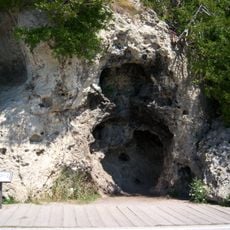
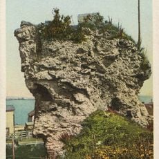
Rabbit's Back, Natural promontory near St. Ignace, Michigan, US

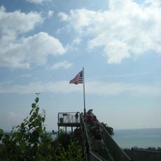
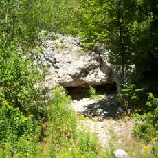
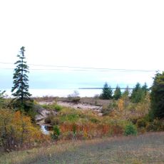
Rabbit's Back is a limestone formation that extends eastward into Lake Huron, separating Evergreen Shores to the south from Horseshoe Bay to the north. The rocky promontory rises prominently above the water and creates a distinct geographical feature along the local shoreline.

The promontory received its name because its shape resembles a crouching rabbit when viewed from the waters near Mackinac Island. Early travelers and sailors passing through the area noticed this distinctive silhouette and named the formation accordingly.

The promontory stands within Hiawatha National Forest, connecting visitors to the natural heritage of Michigan's northern coastline.

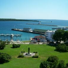
The formation is located several miles north of St. Ignace and is best viewed from the water or nearby vantage points along the shoreline. Visitors can access views of the promontory from various spots without needing special arrangements.

The formation is composed of brecciated limestone from the Straits of Mackinac, a special rock type that resists natural erosion particularly well. This geological composition explains why the distinctive shape has endured over time while surrounding shorelines evolve.

The community of curious travelers

AroundUs brings together thousands of curated places, local tips, and hidden gems, enriched daily by 60,000 contributors worldwide.

Start exploring
GPS coordinates
45.92168,-84.72227
Latest update
December 14, 2025 11:01
Around this place
Mackinac Island
United States of America

Mackinac Island

9.8 km
Grand Hotel
United States of America

Grand Hotel

10.8 km
Fort Mackinac
United States of America

Fort Mackinac

11.2 km
United States of America

Mackinac National Park

10.2 km
Michigan Governor's Summer Residence
United States of America

Michigan Governor's Summer Residence

11.1 km
Castle Rock
United States of America

Castle Rock

1.9 km
Mackinac Bridge Walk
United States of America

Mackinac Bridge Walk

11.1 km
Skull Cave
United States of America

Skull Cave

10.8 km
Fort Holmes
United States of America

Fort Holmes

10.8 km
Devil's Kitchen
United States of America

Devil's Kitchen

9.8 km
Father Marquette National Memorial
United States of America

Father Marquette National Memorial

7.8 km
Biddle House
United States of America

Biddle House

11.4 km
Wawatam Lighthouse
United States of America

Wawatam Lighthouse

6.2 km
Straits State Park
United States of America

Straits State Park

7.7 km
Marquette Park
United States of America

Marquette Park

11.3 km
McGulpin House
United States of America

McGulpin House

11.3 km
British Landing
United States of America

British Landing

7.7 km
Robert Stuart House
United States of America

Robert Stuart House

11.3 km
St. Anthony's Rock
United States of America

St. Anthony's Rock

6 km
St. Ignace Mission
United States of America

St. Ignace Mission

5.6 km
Matthew Geary House
United States of America

Matthew Geary House

11.3 km
John Chambers House
United States of America

John Chambers House

6.1 km
Gros Cap Archaeological District
United States of America

Gros Cap Archaeological District

8.6 km
Marquette Street Archaeological District
United States of America

Marquette Street Archaeological District

6.2 km
Mackinac Trail – Carp River Bridge
United States of America

Mackinac Trail – Carp River Bridge

10.8 km
Sacred Heart-Gros Cap Church
United States of America

Sacred Heart-Gros Cap Church

10 km
Gros Cap and Saint Helena Island Historical Marker
United States of America

Gros Cap and Saint Helena Island Historical Marker

8.6 km
Market Street Historical Marker
United States of America

Market Street Historical Marker

11.3 km
Show the full map
Reviews
Share your experience

No review yet

Discussions
Start a discussion...

No discussion yet

« Rabbit's Back - Natural promontory near St. Ignace, Michigan, US » is provided by Around Us (aroundus.com). Images and texts are derived from Wikimedia project under a Creative Commons license. You are allowed to copy, distribute, and modify copies of this page, under the conditions set by the license, as long as this note is clearly visible.

Discover hidden gems everywhere you go!

From secret cafés to breathtaking viewpoints, skip the crowded tourist spots and find places that match your style. Our app makes it easy with voice search, smart filtering, route optimization, and insider tips from travelers worldwide. Download now for the complete mobile experience.

Around Us App Screenshot

A unique approach to discovering new places

Le Figaro

All the places worth exploring

France Info

A tailor-made excursion in just a few clicks

20 Minutes

Around Us
Travel Guide & Maps
Download

Send to your phone

QR Code
1

Open the camera app on your mobile.

2

Point at the QR code with your camera. A notification will appear.

3

Tap the notification to open the link.