Enable Location

We need your location to show you interesting places around you

Discover nearby places

Find interesting locations and hidden gems around you

Precise directions

Get accurate directions and distances to places

Your location is never shared with other users. It's only used when you tap the location button.

Redwood County Poor Farm

Log in to your account

Start exploring — it's free

Trusted by 62,847 travelers worldwide

Continue with Google
Continue with Apple
or

We will send you a code to connect

By continuing, you accept our Terms and Conditions and our Privacy Policy

Check your inbox

We've sent a pincode in your inbox. Please enter the code below.

Redwood County Poor Farm

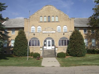
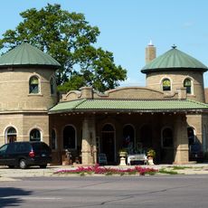
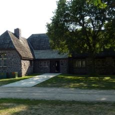
Redwood County Poor Farm, Social welfare institution in Redwood Falls, Minnesota.

The Redwood County Poor Farm is a social welfare institution in Redwood Falls, Minnesota, now operating as a museum. The building contains approximately 30 rooms with exhibits of farming tools, medical equipment, military items, and clothing from past centuries.

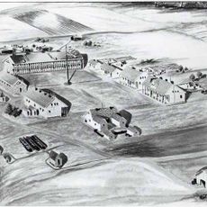
This facility was established in 1884 and served as a shelter for elderly and impoverished residents until 1967. During this period, it provided housing and agricultural work opportunities for people without means.

The museum displays period rooms that recreate everyday settings like a dining area, kitchen, and doctor's office from different times. Walking through these spaces gives visitors a sense of how people lived and worked in those eras.

The site is open from May through September, Thursday to Sunday between noon and 4 PM. Visitors should arrive early in the day to explore all exhibition rooms at a comfortable pace.

The museum also displays taxidermied wildlife and musical instruments, revealing how people in the region spent their leisure time. These collections offer insights into aspects of life that extended beyond the institution itself.

The community of curious travelers

AroundUs brings together thousands of curated places, local tips, and hidden gems, enriched daily by 60,000 contributors worldwide.

Start exploring
GPS coordinates
44.54431,-95.13417
Latest update
December 14, 2025 18:08
Around this place
Hermann Heights Monument
United States of America

Hermann Heights Monument

58.8 km
Jeffers Petroglyphs
United States of America

Jeffers Petroglyphs

50.8 km
Fort Ridgely
United States of America

Fort Ridgely

33.6 km
Flandrau State Park
United States of America

Flandrau State Park

59.8 km
Fort Ridgely State Park
United States of America

Fort Ridgely State Park

34 km
Upper Sioux Agency State Park
United States of America

Upper Sioux Agency State Park

33.2 km
Andrew John Volstead House
United States of America

Andrew John Volstead House

43.6 km
Renville County Courthouse and Jail
United States of America

Renville County Courthouse and Jail

28.4 km
Sacred Heart Public School
United States of America

Sacred Heart Public School

31.6 km
Old Masonic Temple
United States of America

Old Masonic Temple

53.1 km
Godahl Store
United States of America

Godahl Store

62.5 km
Gibbon Village Hall
United States of America

Gibbon Village Hall

48.2 km
Wanda Gág House
United States of America

Wanda Gág House

59 km
New Ulm Oil Company Service Station
United States of America

New Ulm Oil Company Service Station

58.9 km
Milroy State Bank Building
United States of America

Milroy State Bank Building

36.1 km
Bridge No. 5151-Marshall
United States of America

Bridge No. 5151-Marshall

54 km
St. Cornelia's Episcopal Church
United States of America

St. Cornelia's Episcopal Church

11.1 km
Laura Ingalls Wilder Museum
United States of America

Laura Ingalls Wilder Museum

44.7 km
Bridge No. 5083-Marshall
United States of America

Bridge No. 5083-Marshall

52.8 km
Fagen Fighters WWII Museum
United States of America

Fagen Fighters WWII Museum

40.7 km
Flandrau State Park CCC/WPA/Rustic Style Historic Resources
United States of America

Flandrau State Park CCC/WPA/Rustic Style Historic Resources

59.8 km
Fort Ridgely State Park CCC/Rustic Style Historic Resources
United States of America

Fort Ridgely State Park CCC/Rustic Style Historic Resources

33.2 km
Joseph Brown House Ruins
United States of America

Joseph Brown House Ruins

22.6 km
Harkin Store
United States of America

Harkin Store

46 km
Fort Ridgely
United States of America

Fort Ridgely

34.1 km
August Schell Brewing Company
United States of America

August Schell Brewing Company

61.3 km
Old Main, Dr. Martin Luther College
United States of America

Old Main, Dr. Martin Luther College

59 km
Minnesota Machinery Museum
United States of America

Minnesota Machinery Museum

41.8 km
Show the full map
« Redwood County Poor Farm - Social welfare institution in Redwood Falls, Minnesota » is provided by Around Us (aroundus.com). Images and texts are derived from Wikimedia project under a Creative Commons license. You are allowed to copy, distribute, and modify copies of this page, under the conditions set by the license, as long as this note is clearly visible.

Discover hidden gems everywhere you go!

From secret cafés to breathtaking viewpoints, skip the crowded tourist spots and find places that match your style. Our app makes it easy with voice search, smart filtering, route optimization, and insider tips from travelers worldwide. Download now for the complete mobile experience.

Around Us App Screenshot

A unique approach to discovering new places

Le Figaro

All the places worth exploring

France Info

A tailor-made excursion in just a few clicks

20 Minutes

Around Us
Travel Guide & Maps
Download

Send to your phone

QR Code
1

Open the camera app on your mobile.

2

Point at the QR code with your camera. A notification will appear.

3

Tap the notification to open the link.