Enable Location

We need your location to show you interesting places around you

Discover nearby places

Find interesting locations and hidden gems around you

Precise directions

Get accurate directions and distances to places

Your location is never shared with other users. It's only used when you tap the location button.

Riverfront Parkway

Log in to your account

Start exploring — it's free

Trusted by 61,897 travelers worldwide

Continue with Google
Continue with Apple
or

We will send you a code to connect

By continuing, you accept our Terms and Conditions and our Privacy Policy

Check your inbox

We've sent a pincode in your inbox. Please enter the code below.

Riverfront Parkway

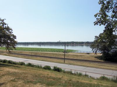
Riverfront Parkway, Recreational park along Mississippi River in Davenport, US.

Riverfront Parkway is a recreational park that runs along the Mississippi River and links multiple park areas through Davenport and Bettendorf using dedicated walking trails. The system connects different sections where visitors can walk, jog, or simply enjoy river views.

The creation of this park system transformed the waterfront into a public space accessible to the community. This change allowed residents to connect more directly with the river and its surroundings.

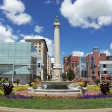
Public art installations appear throughout the park at different locations, adding visual interest to the landscape. These pieces are part of ongoing efforts to make the space more engaging for people who visit.

Multiple entry points and parking areas are distributed along the park system, making access convenient from different locations. Visitors can start their walk from the point most suitable for them.

Credit Island contains its own looped trail that gives visitors an extended walking experience within the larger park system. This section demonstrates how the park incorporates different natural areas.

The community of curious travelers

AroundUs brings together thousands of curated places, local tips, and hidden gems, enriched daily by 60,000 contributors worldwide.

Start exploring
Location
GPS coordinates
41.51940,-90.56940
Latest update
December 14, 2025 18:41
Around this place
Government Bridge
United States of America

Government Bridge

210 m
Figge Art Museum
United States of America

Figge Art Museum

582 m
Davenport Skybridge
United States of America

Davenport Skybridge

472 m
Lock and Dam No. 15
United States of America

Lock and Dam No. 15

98 m
Fort Armstrong
United States of America

Fort Armstrong

561 m
United States of America

River Music Experience

543 m
Mississippi Lofts and Adler Theatre
United States of America

Mississippi Lofts and Adler Theatre

530 m
Davenport Bank and Trust
United States of America

Davenport Bank and Trust

621 m
Davenport Public Library
United States of America

Davenport Public Library

642 m
J.H.C. Petersen's Sons' Store
United States of America

J.H.C. Petersen's Sons' Store

526 m
MidAmerican Energy Building
United States of America

MidAmerican Energy Building

434 m
First National Bank Building
United States of America

First National Bank Building

547 m
Putnam-Parker Block
United States of America

Putnam-Parker Block

475 m
Hibernia Hall
United States of America

Hibernia Hall

611 m
Union Arcade
United States of America

Union Arcade

471 m
Dillon Memorial
United States of America

Dillon Memorial

520 m
First Federal Savings and Loan Association Building
United States of America

First Federal Savings and Loan Association Building

571 m
United States Courthouse
United States of America

United States Courthouse

547 m
Democrat Building
United States of America

Democrat Building

624 m
Hose Station No. 1
United States of America

Hose Station No. 1

284 m
Davenport Downtown Commercial Historic District
United States of America

Davenport Downtown Commercial Historic District

404 m
Renwick Building
United States of America

Renwick Building

591 m
Forrest Block
United States of America

Forrest Block

530 m
Davenport Bag and Paper Company Building
United States of America

Davenport Bag and Paper Company Building

225 m
Davenport Motor Row and Industrial Historic District
United States of America

Davenport Motor Row and Industrial Historic District

263 m
Donahue Building
United States of America

Donahue Building

624 m
Henry Ebeling House
United States of America

Henry Ebeling House

401 m
LeClaire Park
United States of America

LeClaire Park

631 m
Show the full map
« Riverfront Parkway - Recreational park along Mississippi River in Davenport, US » is provided by Around Us (aroundus.com). Images and texts are derived from Wikimedia project under a Creative Commons license. You are allowed to copy, distribute, and modify copies of this page, under the conditions set by the license, as long as this note is clearly visible.

Discover hidden gems everywhere you go!

From secret cafés to breathtaking viewpoints, skip the crowded tourist spots and find places that match your style. Our app makes it easy with voice search, smart filtering, route optimization, and insider tips from travelers worldwide. Download now for the complete mobile experience.

Around Us App Screenshot

A unique approach to discovering new places

Le Figaro

All the places worth exploring

France Info

A tailor-made excursion in just a few clicks

20 Minutes

Around Us
Travel Guide & Maps
Download

Send to your phone

QR Code
1

Open the camera app on your mobile.

2

Point at the QR code with your camera. A notification will appear.

3

Tap the notification to open the link.