Enable Location

We need your location to show you interesting places around you

Discover nearby places

Find interesting locations and hidden gems around you

Precise directions

Get accurate directions and distances to places

Your location is never shared with other users. It's only used when you tap the location button.

Government Bridge

Log in to your account

Start exploring — it's free

Trusted by 63,012 travelers worldwide

Continue with Google
Continue with Apple
or

We will send you a code to connect

By continuing, you accept our Terms and Conditions and our Privacy Policy

Check your inbox

We've sent a pincode in your inbox. Please enter the code below.

Discussion Reviews 1 Photos
10.6k Popularity

Government Bridge, Steel railway and road bridge in Davenport, United States

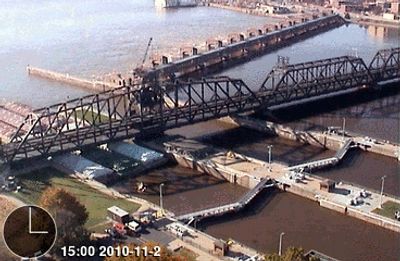
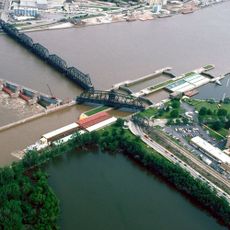
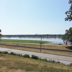
Government Bridge is a steel structure with two levels that spans the Mississippi River, with railroad tracks on the upper level and a roadway below for vehicles. The bridge stretches about 490 meters and connects Davenport, Illinois to Iowa on the opposite bank.

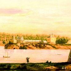
The bridge was built in 1896 and replaced three earlier structures that had stood at this crossing. Abraham Lincoln played a role in defending the original bridge at this location during legal disputes about its importance.

The bridge links two states and serves as a vital crossing point for people and goods moving between regions. It stands as a symbol of how river communities developed their connections to the wider world.

Vehicles on the lower deck must clear a height restriction of about 11 feet, so taller trucks need to be cautious. Traffic flows in both directions across the structure, so watch for other vehicles and pedestrians when crossing.

The bridge features a rotating swing section that turns 360 degrees to allow riverboats to pass through the Mississippi River lock and dam system below. This moving section is a notable engineering feature that demonstrates how the structure adapts to both land and water traffic needs.

The community of curious travelers

AroundUs brings together thousands of curated places, local tips, and hidden gems, enriched daily by 60,000 contributors worldwide.

Start exploring
Location
Official opening
1896
Length
490 m
Made from material
steel
GPS coordinates
41.51920,-90.56690
Latest update
December 8, 2025 19:51
Around this place
Davenport Skybridge
United States of America

Davenport Skybridge

681 m
Lock and Dam No. 15
United States of America

Lock and Dam No. 15

180 m
Blackhawk Hotel
United States of America

Blackhawk Hotel

596 m
Fort Armstrong
United States of America

Fort Armstrong

391 m
United States of America

River Music Experience

746 m
Mississippi Lofts and Adler Theatre
United States of America

Mississippi Lofts and Adler Theatre

706 m
Quad City Botanical Center
United States of America

Quad City Botanical Center

1.1 km
Gordon–Van Tine Company Historic District
United States of America

Gordon–Van Tine Company Historic District

753 m
J.H.C. Petersen's Sons' Store
United States of America

J.H.C. Petersen's Sons' Store

730 m
Antoine LeClaire House
United States of America

Antoine LeClaire House

876 m
MidAmerican Energy Building
United States of America

MidAmerican Energy Building

624 m
Putnam-Parker Block
United States of America

Putnam-Parker Block

674 m
Union Arcade
United States of America

Union Arcade

653 m
Dillon Memorial
United States of America

Dillon Memorial

729 m
Henry H. Smith/J.H. Murphy House
United States of America

Henry H. Smith/J.H. Murphy House

771 m
United States Courthouse
United States of America

United States Courthouse

707 m
Riverfront Parkway
United States of America

Riverfront Parkway

210 m
Hose Station No. 1
United States of America

Hose Station No. 1

479 m
Davenport Downtown Commercial Historic District
United States of America

Davenport Downtown Commercial Historic District

510 m
Forrest Block
United States of America

Forrest Block

706 m
Davenport Bag and Paper Company Building
United States of America

Davenport Bag and Paper Company Building

395 m
Davenport Motor Row and Industrial Historic District
United States of America

Davenport Motor Row and Industrial Historic District

427 m
Swedish Baptist Church
United States of America

Swedish Baptist Church

862 m
Henry Ebeling House
United States of America

Henry Ebeling House

367 m
Warner Apartment Building
United States of America

Warner Apartment Building

787 m
M.V. Gannon House
United States of America

M.V. Gannon House

832 m
Isaac Glaspell House
United States of America

Isaac Glaspell House

773 m
Henry Ockershausen House
United States of America

Henry Ockershausen House

1.1 km
Show the full map
Reviews
Share your experience

No review yet

Discussions
Start a discussion...

No discussion yet

« Government Bridge - Steel railway and road bridge in Davenport, United States » is provided by Around Us (aroundus.com). Images and texts are derived from Wikimedia project under a Creative Commons license. You are allowed to copy, distribute, and modify copies of this page, under the conditions set by the license, as long as this note is clearly visible.

Discover hidden gems everywhere you go!

From secret cafés to breathtaking viewpoints, skip the crowded tourist spots and find places that match your style. Our app makes it easy with voice search, smart filtering, route optimization, and insider tips from travelers worldwide. Download now for the complete mobile experience.

Around Us App Screenshot

A unique approach to discovering new places

Le Figaro

All the places worth exploring

France Info

A tailor-made excursion in just a few clicks

20 Minutes

Around Us
Travel Guide & Maps
Download

Send to your phone

QR Code
1

Open the camera app on your mobile.

2

Point at the QR code with your camera. A notification will appear.

3

Tap the notification to open the link.