·

Enable Location

We need your location to show you interesting places around you

Discover nearby places

Find interesting locations and hidden gems around you

Precise directions

Get accurate directions and distances to places

Your location is never shared with other users. It's only used when you tap the location button.

River Des Peres Park

Log in to your account

Start exploring — it's free

Trusted by 62,646 travelers worldwide

Continue with Google
Continue with Apple
or

We will send you a code to connect

By continuing, you accept our Terms and Conditions and our Privacy Policy

Check your inbox

We've sent a pincode in your inbox. Please enter the code below.

River Des Peres Park

River Des Peres Park, park in Missouri, United States of America

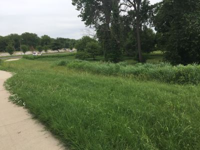
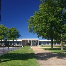
River Des Peres Park is a long, narrow strip of land along a creek in St. Louis that spans about 145 acres and runs through two neighborhoods. The park features a playground, fields for soccer and baseball, rain gardens planted with water-loving trees, and bridges with vertical garden walls that help cool the surfaces.

The park was established in 1926 to provide outdoor space for St. Louis residents along the creek. The connected River Des Peres Greenway Trail was built in stages starting in 2005, linking the park to other green spaces across the city.

The park draws its name from the River Des Peres creek, which shapes the identity of the neighborhood and has influenced how residents live and interact with the space. Locals use it for everyday activities like dog walking and casual gatherings, making it a familiar gathering spot for the community.

Plan to arrive on foot or by bike, as there is no dedicated parking lot; use nearby residential streets instead. The park is open from early morning to late evening and connects to a larger network of trails through the River Des Peres Greenway for longer walks or bike rides.

The park features bridges with vertical garden walls that do more than look interesting; the plants help cool the bridge surfaces as part of urban cooling efforts. These green walls demonstrate how infrastructure blends with natural features to provide practical environmental benefits.

The community of curious travelers

AroundUs brings together thousands of curated places, local tips, and hidden gems, enriched daily by 60,000 contributors worldwide.

Start exploring
Location
Inception
1934
GPS coordinates
38.58300,-90.31200
Latest update
February 9, 2026 07:43
Around this place
Forest Park
United States of America

Forest Park

6.7 km
Missouri Botanical Garden
United States of America

Missouri Botanical Garden

5.8 km
Saint Louis Zoo
United States of America

Saint Louis Zoo

6.1 km
Saint Louis Art Museum
United States of America

Saint Louis Art Museum

6.5 km
Ulysses S. Grant National Historic Site
United States of America

Ulysses S. Grant National Historic Site

4.9 km
Saint Louis Science Center
United States of America

Saint Louis Science Center

6.2 km
Apotheosis of St. Louis
United States of America

Apotheosis of St. Louis

6.5 km
Climatron
United States of America

Climatron

5.8 km
Tower Grove Park
United States of America

Tower Grove Park

5.5 km
Affton High School
United States of America

Affton High School

2.8 km
Jewel Box
United States of America

Jewel Box

6.4 km
Queeny Tower
United States of America

Queeny Tower

7.1 km
United States of America

St. Louis Islamic Center

5.3 km
United States of America

Seiwa-en

5.3 km
Monsanto Insectarium
United States of America

Monsanto Insectarium

6 km
Statue of Christopher Columbus
United States of America

Statue of Christopher Columbus

6.5 km
United States of America

Christy Park

3.1 km
United States of America

St. Louis Modern Chinese School

5.7 km
Joseph Sappington House
United States of America

Joseph Sappington House

6.3 km
Fairfax House
United States of America

Fairfax House

5.4 km
Greenwood Historic District
United States of America

Greenwood Historic District

2.6 km
Brentwood Public Library
United States of America

Brentwood Public Library

5 km
Forest Park Southeast Historic District
United States of America

Forest Park Southeast Historic District

6.8 km
Wydown-Forsyth District
United States of America

Wydown-Forsyth District

6.8 km
St. Louis Municipal Opera Theatre
United States of America

St. Louis Municipal Opera Theatre

6.9 km
Zephaniah Sappington House
United States of America

Zephaniah Sappington House

6.8 km
Oakland House
United States of America

Oakland House

1.5 km
Thomas J. Sappington House
United States of America

Thomas J. Sappington House

6.6 km
Show the full map
« River Des Peres Park - park in Missouri, United States of America » is provided by Around Us (aroundus.com). Images and texts are derived from Wikimedia project under a Creative Commons license. You are allowed to copy, distribute, and modify copies of this page, under the conditions set by the license, as long as this note is clearly visible.

Discover hidden gems everywhere you go!

From secret cafés to breathtaking viewpoints, skip the crowded tourist spots and find places that match your style. Our app makes it easy with voice search, smart filtering, route optimization, and insider tips from travelers worldwide. Download now for the complete mobile experience.

Around Us App Screenshot

A unique approach to discovering new places

Le Figaro

All the places worth exploring

France Info

A tailor-made excursion in just a few clicks

20 Minutes

Around Us
Travel Guide & Maps
Download

Send to your phone

QR Code
1

Open the camera app on your mobile.

2

Point at the QR code with your camera. A notification will appear.

3

Tap the notification to open the link.