Rocks State Park

Log in to your account

AroundUs is a community-driven map of interesting places, built by curious explorers like you. It grows with every review, story, and photo you share.
Connect to save your favorite spots, contribute locations, and create personalized routes.
Continue with Google
Continue with Apple
Continue with X
Continue with Facebook
Continue with email
By continuing, you accept our Terms and Conditions and our Privacy Policy
Create an account
Add to collection
Map
Suggest a change
Share

Rocks State Park, State park with geological formations in Harford County, US.

Rocks State Park is an 855-acre conservation area in Harford County with rocky cliffs, forests, and hiking trails along Deer Creek. The park consists of three separate sections: the main area on Rocks Ridge, the Falling Branch section with Kilgore Falls, and Hidden Valley, which together offer different landscapes and geological features.

The park was established in 1949 by the Maryland Department of Natural Resources and was originally named Deer Creek State Park before being renamed Rocks State Park. This renaming reflected growing recognition of the area's geological significance.

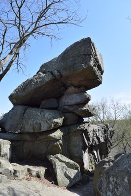
The park's name directly reflects the rock formations that shape the landscape and have drawn people's attention for generations. The King and Queen Seat formation serves as a recognizable gathering point and overlook that locals and visitors have long referenced in stories and writings.

The park is divided into three separate sections located in different areas, each offering different experiences, so visitors should plan which sections to explore. Hiking boots and plenty of water are helpful, especially when tackling steeper trails or waterfall routes.

The Falling Branch section of the park contains a waterfall standing at 190 feet tall, making it the second-highest in Maryland, and it flows through dense forest. This water feature often gets overlooked because it sits in a separate park section and is less widely known than the more prominent King and Queen Seat formation.

Location: Harford County

Inception: 1949

Operator: Maryland Park Service

Website: https://dnr.maryland.gov/publiclands/Pages/central/rocks.aspx

GPS coordinates: 39.64000,-76.42000

Latest update: December 6, 2025 16:04

Photos
Places to discover in Maryland: coast lighthouses, wildlife sanctuaries, waterfalls, and gardens

Maryland has many places to see away from the usual crowds. Natural areas fill the state: sanctuaries where birds and mammals live, waterfalls carving through forests, and coastlines with calm views over the water. History is everywhere: white lighthouses that guided ships for centuries, colonial...

Around this place
Bel Air High School
United States of America

Bel Air High School

12.6 km
Ladew Topiary Gardens
United States of America

Ladew Topiary Gardens

10.3 km
My Lady's Manor
United States of America

My Lady's Manor

14.2 km
Liriodendron
United States of America

Liriodendron

12.9 km
Bel Air Armory
United States of America

Bel Air Armory

12.9 km
Ivory Mills
United States of America

Ivory Mills

10.8 km
Hidden Valley Farm
United States of America

Hidden Valley Farm

14.4 km
Muddy Creek Forks Historic District
United States of America

Muddy Creek Forks Historic District

19.2 km
Bon Air
United States of America

Bon Air

14.7 km
Hays House
United States of America

Hays House

13.5 km
The Vineyard
United States of America

The Vineyard

10.6 km
Coulsontown Cottages Historic District
United States of America

Coulsontown Cottages Historic District

13.5 km
Harford National Bank
United States of America

Harford National Bank

13.1 km
Delta Trestle Bridge, Maryland and Pennsylvania Railroad
United States of America

Delta Trestle Bridge, Maryland and Pennsylvania Railroad

12.5 km
Proctor House
United States of America

Proctor House

12.6 km
Col. John Streett House
United States of America

Col. John Streett House

2.3 km
Bel Air Courthouse Historic District
United States of America

Bel Air Courthouse Historic District

13.1 km
Joshua's Meadows
United States of America

Joshua's Meadows

14 km
Heighe House
United States of America

Heighe House

12.2 km
Gladden Farm
United States of America

Gladden Farm

1.2 km
Rockdale
United States of America

Rockdale

11.8 km
Whiteford-Cardiff Historic District
United States of America

Whiteford-Cardiff Historic District

10.9 km
Graham-Crocker House
United States of America

Graham-Crocker House

13 km
Mill Green Historic District
United States of America

Mill Green Historic District

8.5 km
Slate Ridge School
United States of America

Slate Ridge School

10.6 km
Delta Historic District
United States of America

Delta Historic District

12.1 km
Payne's Folly
United States of America

Payne's Folly

11.8 km
Maze Quest Fun Park
United States of America

Maze Quest Fun Park

15.7 km
Show the full map
Reviews

Visited this place? Tap the stars to rate it and share your experience / photos with the community! Try now! You can cancel it anytime.

« Rocks State Park - State park with geological formations in Harford County, US » is provided by Around Us (aroundus.com). Images and texts are derived from Wikimedia project under a Creative Commons license. You are allowed to copy, distribute, and modify copies of this page, under the conditions set by the license, as long as this note is clearly visible.

Discover hidden gems everywhere you go!

From secret cafés to breathtaking viewpoints, skip the crowded tourist spots and find places that match your style. Our app makes it easy with voice search, smart filtering, route optimization, and insider tips from travelers worldwide. Download now for the complete mobile experience.

Around Us App Screenshot

A unique approach to discovering new places

Le Figaro

All the places worth exploring

France Info

A tailor-made excursion in just a few clicks

20 Minutes