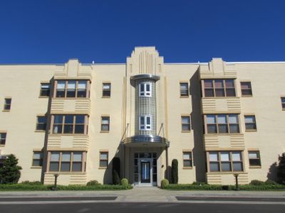
Rosedale Apartments, Historic apartment building at Narragansett Boulevard in Cranston, United States.
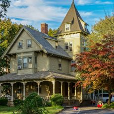
Rosedale Apartments is a three-story residential building with a U-shaped floor plan located on Narragansett Boulevard in Cranston. The structure extends to a fourth floor on the waterfront side due to the sloped terrain of the property.
Architect Herbert R. Hunt designed and oversaw construction of this complex between 1939 and 1940. The building arose during a period when Art Moderne architecture was gaining prominence in America and reshaping residential design standards.
The building displays Art Moderne design features popular during the 1930s, visible in its curved corners and smooth facades. These architectural elements remain clearly visible to visitors exploring the property today.
The property spans about 1 hectare (2.7 acres) and contains multiple residential units visible from street level. Its historic designation means that major renovations or alterations must follow strict preservation guidelines.
The property earned recognition in 2007 as a significant example of large-scale Art Moderne residential architecture in Rhode Island. Its clever use of sloped terrain creates visual interest from multiple viewpoints as the building appears to shift in height depending on your vantage point.
Location: Cranston
GPS coordinates: 41.78250,-71.39278
Latest update: December 14, 2025 18:48
Roger Williams Park Zoo
2.1 km
Roger Williams Park
1.5 km
Pawtuxet Village
2.1 km
Pomham Rocks Light
2 km
Roger Williams Park Museum of Natural History and Planetarium
1.8 km
Squantum Association
1.8 km
Roger Williams Park Botanical Center
1.2 km
Rhodes-on-the Pawtuxet
1.6 km
James Dennis House
2.4 km
St. Michael's Roman Catholic Church, Convent, Rectory, and School
2.7 km
Return Sludge Pumping Station, Fields Point Sewage Treatment Plant
1.4 km
Roger Williams Botanical Center
1.2 km
Bicknell-Armington Lightning Splitter House
2.6 km
Christopher Rhodes House
2.1 km
Phillipsdale Historic District
2.1 km
Edgewood Historic District-Shaw Plat
841 m
Fuller Rock Light
1.7 km
Sassafras Point Light
2 km
Chemical Building, Fields Point Sewage Treatment Plant
1.3 km
Washington Park Sewage Pumping Station
1 km
Whitcomb Farm
2.6 km
Edgewood Historic District-Sally Greene Homestead Plats
1.1 km
Edgewood Historic District–Anstis Greene Estate Plats
977 m
Edgewood Historic District-Arnold Farm Plat
635 m
Ernest Street Sewage Pumping Station
1.5 km
Plymouth Congregational Church
2.4 km
Edgewood Historic District-Aberdeen Plat
1.3 km
Edgewood Historic District-Taft Estate Plat
1.3 kmVisited this place? Tap the stars to rate it and share your experience / photos with the community! Try now! You can cancel it anytime.
Discover hidden gems everywhere you go!
From secret cafés to breathtaking viewpoints, skip the crowded tourist spots and find places that match your style. Our app makes it easy with voice search, smart filtering, route optimization, and insider tips from travelers worldwide. Download now for the complete mobile experience.
A unique approach to discovering new places❞
— Le Figaro
All the places worth exploring❞
— France Info
A tailor-made excursion in just a few clicks❞
— 20 Minutes