Pomham Rocks Light
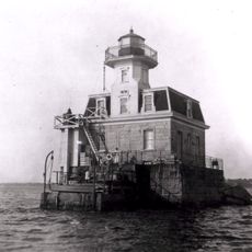
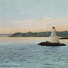
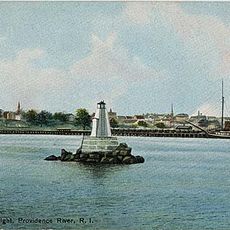
Pomham Rocks Light, Historic lighthouse in East Providence, United States.
Pomham Rocks Light is an octagonal wooden lighthouse with a white exterior and black lantern tower, standing about 12 meters tall on a square stone foundation. Its red roof and compact structure rest directly on the rocks in the middle of the Providence River.
The station began operations in 1871 with a sixth-order Fresnel lens displaying a fixed white light initially. The light changed to red in 1872, making it easier to distinguish from other beacons in the busy river.
The name Pomham comes from a Narragansett Indian sachem who once held power in this region. The two rocky islets connected by a natural bar at low tide create a distinctive landmark in the river.
The best view comes from the East Bay Bike Path, which runs roughly 300 meters away on the eastern shore. You can also see it from the water near Johnson and Wales University on the opposite bank.
In 1932, an emergency appendectomy was performed inside the lighthouse when the keeper's daughter Marjorie fell ill. A doctor could not reach the tower in time, so the operation had to be performed right there on the rocks.
Location: East Providence
Inception: 1871
Height: 12 m
Operator: U.S. Coast Guard
Address: PO 15121, Riverside, RI 02915, USA
Website: https://pomhamrockslighthouse.org
GPS coordinates: 41.77763,-71.36952
Latest update: December 6, 2025 17:44
Providence sits in the northeastern United States and presents itself as a city that has developed over several centuries. The area around Benefit Street preserves colonial wooden houses with narrow windows and steep roofs. The Rhode Island State House stands on a hill with its white marble cladding...
Pawtuxet Village
2.4 km
Crescent Park Looff Carousel
2.5 km
Crescent Park
2.6 km
Squantum Association
1.4 km
Rhodes-on-the Pawtuxet
2.2 km
Sabin Point Light
1.8 km
James Dennis House
1.3 km
Rosedale Apartments
2 km
Return Sludge Pumping Station, Fields Point Sewage Treatment Plant
2.4 km
Roger Williams Botanical Center
3.2 km
Bicknell-Armington Lightning Splitter House
547 m
Christopher Rhodes House
2.4 km
Phillipsdale Historic District
2.4 km
Edgewood Historic District-Shaw Plat
2.1 km
Fuller Rock Light
2 km
Sassafras Point Light
3.2 km
Chemical Building, Fields Point Sewage Treatment Plant
2.6 km
District 6 Schoolhouse
1.3 km
Whitcomb Farm
587 m
Washington Park Sewage Pumping Station
2.3 km
Elm Tree Plat Historic District
1.6 km
Edgewood Historic District-Sally Greene Homestead Plats
1.9 km
Rose Land Park Plat Historic District
1.8 km
Edgewood Historic District–Anstis Greene Estate Plats
2.1 km
Edgewood Historic District-Arnold Farm Plat
2.2 km
Ernest Street Sewage Pumping Station
3 km
Edgewood Historic District-Aberdeen Plat
2.1 km
Edgewood Historic District-Taft Estate Plat
1.9 kmVisited this place? Tap the stars to rate it and share your experience / photos with the community! Try now! You can cancel it anytime.
Discover hidden gems everywhere you go!
From secret cafés to breathtaking viewpoints, skip the crowded tourist spots and find places that match your style. Our app makes it easy with voice search, smart filtering, route optimization, and insider tips from travelers worldwide. Download now for the complete mobile experience.
A unique approach to discovering new places❞
— Le Figaro
All the places worth exploring❞
— France Info
A tailor-made excursion in just a few clicks❞
— 20 Minutes