Sabin Point Light

Log in to your account

AroundUs is a community-driven map of interesting places, built by curious explorers like you. It grows with every review, story, and photo you share.
Connect to save your favorite spots, contribute locations, and create personalized routes.
Continue with Google
Continue with Apple
Continue with X
Continue with Facebook
Continue with email
By continuing, you accept our Terms and Conditions and our Privacy Policy
Create an account
Add to collection
Map
Suggest a change
Share

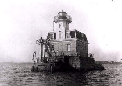
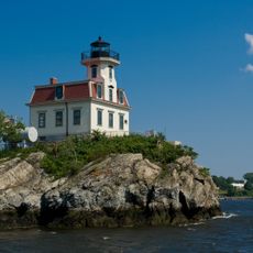
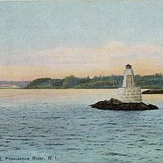
Sabin Point Light, Maritime navigation light in Providence River, Rhode Island, US

Sabin Point Light is a two-story granite lighthouse with a lantern room rising 36 feet (11 m) above the Providence River. The structure held a Sixth Order Fresnel Lens and a fog bell that sounded every nine seconds to help guide vessels during poor visibility.

This navigation aid came into service in 1872 to support growing river traffic in the Providence area. It served as a critical guide for vessels navigating the narrow channels and changing water conditions of the river for decades.

The lighthouse was a workplace and home for keepers and their families, who lived on-site and maintained daily operations. These workers were part of a tight-knit community of river pilots and harbor workers who depended on the beacon's steady light.

The lighthouse stood directly in the river and was accessible only by boat, making isolation a daily reality for those who lived there. Visitors should know that such river-based structures become difficult to reach during heavy storms and extreme weather conditions.

The structure withstood the devastating 1938 hurricane despite severe flood damage that swept through the area. During this disaster, the keeper's wife was caught by floodwaters multiple times but remarkably returned safely each time.

Location: Rhode Island

Inception: 1872

GPS coordinates: 41.76194,-71.37417

Latest update: December 14, 2025 16:40

Photos
Around this place
Pawtuxet Village
United States of America

Pawtuxet Village

1.4 km
Crescent Park Looff Carousel
United States of America

Crescent Park Looff Carousel

1.4 km
Crescent Park
United States of America

Crescent Park

1.5 km
Belton Court
United States of America

Belton Court

3.4 km
Pomham Rocks Light
United States of America

Pomham Rocks Light

1.8 km
Squantum Association
United States of America

Squantum Association

3.1 km
Rhodes-on-the Pawtuxet
United States of America

Rhodes-on-the Pawtuxet

1.6 km
Haines Memorial State Park
United States of America

Haines Memorial State Park

3 km
James Dennis House
United States of America

James Dennis House

3.1 km
Rosedale Apartments
United States of America

Rosedale Apartments

2.8 km
Alfred Drowne Road Historic District
United States of America

Alfred Drowne Road Historic District

3.3 km
St. Matthew's Episcopal Church
United States of America

St. Matthew's Episcopal Church

3.3 km
Roger Williams Botanical Center
United States of America

Roger Williams Botanical Center

3.6 km
Bicknell-Armington Lightning Splitter House
United States of America

Bicknell-Armington Lightning Splitter House

1.9 km
Christopher Rhodes House
United States of America

Christopher Rhodes House

1.4 km
Phillipsdale Historic District
United States of America

Phillipsdale Historic District

1.4 km
Edgewood Historic District-Shaw Plat
United States of America

Edgewood Historic District-Shaw Plat

2.3 km
Fuller Rock Light
United States of America

Fuller Rock Light

3.6 km
John Waterman Arnold House
United States of America

John Waterman Arnold House

2.2 km
District 6 Schoolhouse
United States of America

District 6 Schoolhouse

2 km
Washington Park Sewage Pumping Station
United States of America

Washington Park Sewage Pumping Station

3.5 km
Whitcomb Farm
United States of America

Whitcomb Farm

1.9 km
Edgewood Historic District-Sally Greene Homestead Plats
United States of America

Edgewood Historic District-Sally Greene Homestead Plats

1.9 km
Elm Tree Plat Historic District
United States of America

Elm Tree Plat Historic District

2 km
Rose Land Park Plat Historic District
United States of America

Rose Land Park Plat Historic District

2.1 km
Edgewood Historic District–Anstis Greene Estate Plats
United States of America

Edgewood Historic District–Anstis Greene Estate Plats

2.1 km
Edgewood Historic District-Arnold Farm Plat
United States of America

Edgewood Historic District-Arnold Farm Plat

2.5 km
Edgewood Historic District-Aberdeen Plat
United States of America

Edgewood Historic District-Aberdeen Plat

1.8 km
Show the full map
Reviews

Visited this place? Tap the stars to rate it and share your experience / photos with the community! Try now! You can cancel it anytime.

« Sabin Point Light - Maritime navigation light in Providence River, Rhode Island, US » is provided by Around Us (aroundus.com). Images and texts are derived from Wikimedia project under a Creative Commons license. You are allowed to copy, distribute, and modify copies of this page, under the conditions set by the license, as long as this note is clearly visible.

Discover hidden gems everywhere you go!

From secret cafés to breathtaking viewpoints, skip the crowded tourist spots and find places that match your style. Our app makes it easy with voice search, smart filtering, route optimization, and insider tips from travelers worldwide. Download now for the complete mobile experience.

Around Us App Screenshot

A unique approach to discovering new places

Le Figaro

All the places worth exploring

France Info

A tailor-made excursion in just a few clicks

20 Minutes