Enable Location

We need your location to show you interesting places around you

Discover nearby places

Find interesting locations and hidden gems around you

Precise directions

Get accurate directions and distances to places

Your location is never shared with other users. It's only used when you tap the location button.

Log in to your account

Start exploring — it's free

Trusted by 65,911 travelers worldwide

Continue with Google
Continue with Apple
or

We will send you a code to connect

By continuing, you accept our Terms and Conditions and our Privacy Policy

Check your inbox

We've sent a pincode in your inbox. Please enter the code below.

Sandy Island Beach State Park
Discussion Reviews Photo
4.8k Popularity

Sandy Island Beach State Park, State park on Lake Ontario, New York, United States

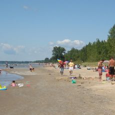
Sandy Island Beach State Park is a New York state park located on the eastern shore of Lake Ontario, featuring sandy beaches, dune formations, wetlands, and forest areas. The shoreline remains largely undeveloped, giving the park a natural character that sets it apart from more built-up beach destinations.

The land functioned as a private beach resort from the 1950s until the early 1970s, when it was taken over and turned into a state park. That change brought formal protection to the shoreline, which had been shaped by decades of seasonal recreational use.

Sandy Island Beach State Park draws birdwatchers who come to spot migratory species moving along the Lake Ontario shoreline. The wetland edges and open sandy areas make it easy to observe wildlife without any special equipment.

The park is most accessible in summer, when the beach and basic facilities are open to visitors. Arriving early on warm weekends is a good idea, as the parking area can fill up quickly on busy days.

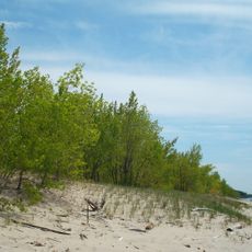
The park contains one of the few freshwater dune systems in the region, where a hardwood forest is slowly taking root in sandy ground over many generations. This gradual shift from open dune to wooded area is rarely seen along the Lake Ontario shore.

The community of curious travelers

AroundUs brings together thousands of curated places, local tips, and hidden gems, enriched daily by 60,000 contributors worldwide.

Start exploring
Location
GPS coordinates
43.63100,-76.19600
Latest update
March 3, 2026 08:16
Around this place
Fort Ontario
United States of America

Fort Ontario

31.2 km
Southwick Beach State Park
United States of America

Southwick Beach State Park

15.4 km
Salmon River Falls
United States of America

Salmon River Falls

22.6 km
Oswego Harbor West Pierhead Light
United States of America

Oswego Harbor West Pierhead Light

31.3 km
Sandy Pond Beach Unique Area
United States of America

Sandy Pond Beach Unique Area

3.2 km
Selkirk Light
United States of America

Selkirk Light

6.3 km
Safe Haven Museum and Education Center
United States of America

Safe Haven Museum and Education Center

31.1 km
Stony Point Light
United States of America

Stony Point Light

24.6 km
Richardson-Bates House
United States of America

Richardson-Bates House

31.6 km
Pulaski Village Historic District
United States of America

Pulaski Village Historic District

9 km
Orson Ames House
United States of America

Orson Ames House

19.3 km
Cyrus Bates House
United States of America

Cyrus Bates House

21.5 km
Carley's Mills Schoolhouse
United States of America

Carley's Mills Schoolhouse

29.4 km
Fred Smart House
United States of America

Fred Smart House

10.3 km
Stillwater Bridge
United States of America

Stillwater Bridge

24.1 km
Smith-Ripley House
United States of America

Smith-Ripley House

24.5 km
Bedford Creek Bridge
United States of America

Bedford Creek Bridge

31.5 km
Norton–Burnham House
United States of America

Norton–Burnham House

23.9 km
Peter Chandler House
United States of America

Peter Chandler House

19.3 km
Phineas Davis Farmstead
United States of America

Phineas Davis Farmstead

18.6 km
First National Bank of Lacona
United States of America

First National Bank of Lacona

10.3 km
Adams Commercial Historic District
United States of America

Adams Commercial Historic District

24.1 km
Timothy Skinner House
United States of America

Timothy Skinner House

19.1 km
Fowler-Loomis House
United States of America

Fowler-Loomis House

19.3 km
Thayer Farmstead
United States of America

Thayer Farmstead

20 km
Lacona Clock Tower
United States of America

Lacona Clock Tower

10.2 km
Leonard Ames Farmhouse
United States of America

Leonard Ames Farmhouse

19.3 km
Mexico Village Historic District
United States of America

Mexico Village Historic District

19.4 km
Show the full map
Reviews
Share your experience

No review yet

Discussions
Start a discussion...

No discussion yet

« Sandy Island Beach State Park - State park on Lake Ontario, New York, United States » is provided by Around Us (aroundus.com). Images and texts are derived from Wikimedia project under a Creative Commons license. You are allowed to copy, distribute, and modify copies of this page, under the conditions set by the license, as long as this note is clearly visible.

Discover hidden gems everywhere you go!

From secret cafés to breathtaking viewpoints, skip the crowded tourist spots and find places that match your style. Our app makes it easy with voice search, smart filtering, route optimization, and insider tips from travelers worldwide. Download now for the complete mobile experience.

Around Us App Screenshot

A unique approach to discovering new places

Le Figaro

All the places worth exploring

France Info

A tailor-made excursion in just a few clicks

20 Minutes

Around Us
Travel Guide & Maps
Download

Send to your phone

QR Code
1

Open the camera app on your mobile.

2

Point at the QR code with your camera. A notification will appear.

3

Tap the notification to open the link.