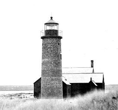
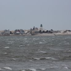
Sandy Neck Light, Maritime navigation lighthouse at Sandy Neck, Barnstable, United States.
Sandy Neck Light is a cylindrical brick tower standing on the sandy spit at Barnstable, rising approximately 16 meters above ground level. The structure features white paint with black horizontal bands and an LED light at the top that marks it clearly against the sky.
Congress approved funding for this navigation tower in 1826, with the town of Barnstable providing the site for a nominal price. After its lantern room was removed in 1931, the structure remained incomplete for decades until restoration efforts culminated in its return to service in 2007.
The lighthouse takes its name from the sandy spit where it stands, serving today as a landmark that connects the community to its maritime heritage. Locals and visitors alike recognize it as a symbol of Barnstable's historical dependence on the sea and coastal trade.
The location on the spit is accessible by foot from downtown Barnstable, though parking near the site is limited. Visitors should be aware of tidal conditions and changing weather, as the area is exposed and can become wet quickly.
Lucy Hinckley Baxter became keeper in 1862 following her husband's accidental death, making her one of the few women to hold such a position during that era. Her tenure illustrates how women played active roles in maritime operations when such opportunities were rare.
The community of curious travelers
AroundUs brings together thousands of curated places, local tips, and hidden gems, enriched daily by 60,000 contributors worldwide.