Enable Location

We need your location to show you interesting places around you

Discover nearby places

Find interesting locations and hidden gems around you

Precise directions

Get accurate directions and distances to places

Your location is never shared with other users. It's only used when you tap the location button.

Log in to your account

Start exploring — it's free

Trusted by 62,370 travelers worldwide

Continue with Google
Continue with Apple
or

We will send you a code to connect

By continuing, you accept our Terms and Conditions and our Privacy Policy

Check your inbox

We've sent a pincode in your inbox. Please enter the code below.

Sinepuxent Bay Wildlife Management Area

Sinepuxent Bay Wildlife Management Area

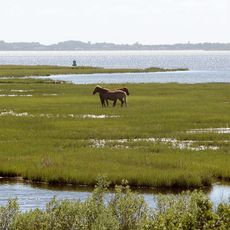
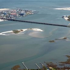
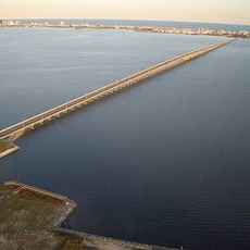
Sinepuxent Bay Wildlife Management Area is a protected area in Maryland consisting of several islands covered with sand, mud, and marsh vegetation. The waterway connects Chincoteague Bay to Ocean City Inlet and forms a boundary between Sinepuxent Neck and Assateague Island.

The protected area was established in the 1960s when Maryland designated the islands for wildlife protection. Most islands originated from dredge spoils from a navigation channel constructed in the 1930s.

The area serves as a critical nesting ground for waterbirds that breed in colonies across its islands. The open landscape of water and marshes reflects how this coastal region relies on natural habitats for its wildlife.

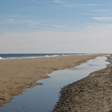
The area is only accessible by boat, with several launching ramps around Ocean City. Most islands are closed during summer months to protect nesting birds, so visitors should watch for posted signs.

Artificial nesting platforms were built to provide threatened seabirds like terns and Black Skimmers with safe breeding sites. These floating rafts have proven successful and now support hundreds of nests annually.

The community of curious travelers

AroundUs brings together thousands of curated places, local tips, and hidden gems, enriched daily by 60,000 contributors worldwide.

Start exploring
Location
Operator
Wildlife and Heritage Service
GPS coordinates
38.23792,-75.15489
Latest update
February 9, 2026 07:41
Around this place
Assateague State Park
United States of America

Assateague State Park

1.4 km
Jolly Roger Amusement Park
United States of America

Jolly Roger Amusement Park

15.2 km
Trimper's Rides
United States of America

Trimper's Rides

11.5 km
Fenwick Island State Park
United States of America

Fenwick Island State Park

28 km
Verrazano Bridge
United States of America

Verrazano Bridge

978 m
Fenwick Island Light
United States of America

Fenwick Island Light

25.3 km
Harry W. Kelley Memorial Bridge
United States of America

Harry W. Kelley Memorial Bridge

11.9 km
Assawoman Bay Bridge
United States of America

Assawoman Bay Bridge

17.7 km
Rackliffe House
United States of America

Rackliffe House

10.8 km
Calvin B. Taylor House
United States of America

Calvin B. Taylor House

11.5 km
St. Martin's Episcopal Church
United States of America

St. Martin's Episcopal Church

17.8 km
Governor John Walter Smith House
United States of America

Governor John Walter Smith House

22.2 km
Merry Sherwood
United States of America

Merry Sherwood

9.6 km
Burley Manor
United States of America

Burley Manor

10.7 km
Genesar
United States of America

Genesar

3 km
United States of America

Wicomico Demonstration Forest

27.8 km
George Washington Purnell House
United States of America

George Washington Purnell House

21.8 km
Berlin Commercial District
United States of America

Berlin Commercial District

11.2 km
James Martin House
United States of America

James Martin House

22.3 km
Samuel Gunn House
United States of America

Samuel Gunn House

22.2 km
Chanceford
United States of America

Chanceford

22.4 km
Thunder Lagoon Water Park
United States of America

Thunder Lagoon Water Park

25.5 km
Capt. Ebe Chandler House
United States of America

Capt. Ebe Chandler House

31.8 km
Caleb's Discovery
United States of America

Caleb's Discovery

11.6 km
Simpson's Grove
United States of America

Simpson's Grove

9.3 km
Henry's Grove
United States of America

Henry's Grove

3.5 km
Captain Robert S. Craig Cottage
United States of America

Captain Robert S. Craig Cottage

12.9 km
Ocean City Life-Saving Station
United States of America

Ocean City Life-Saving Station

11.4 km
Show the full map
« Sinepuxent Bay Wildlife Management Area » is provided by Around Us (aroundus.com). Images and texts are derived from Wikimedia project under a Creative Commons license. You are allowed to copy, distribute, and modify copies of this page, under the conditions set by the license, as long as this note is clearly visible.

Discover hidden gems everywhere you go!

From secret cafés to breathtaking viewpoints, skip the crowded tourist spots and find places that match your style. Our app makes it easy with voice search, smart filtering, route optimization, and insider tips from travelers worldwide. Download now for the complete mobile experience.

Around Us App Screenshot

A unique approach to discovering new places

Le Figaro

All the places worth exploring

France Info

A tailor-made excursion in just a few clicks

20 Minutes

Around Us
Travel Guide & Maps
Download

Send to your phone

QR Code
1

Open the camera app on your mobile.

2

Point at the QR code with your camera. A notification will appear.

3

Tap the notification to open the link.