Enable Location

We need your location to show you interesting places around you

Discover nearby places

Find interesting locations and hidden gems around you

Precise directions

Get accurate directions and distances to places

Your location is never shared with other users. It's only used when you tap the location button.

South Mountains State Park

Log in to your account

Start exploring — it's free

Trusted by 61,762 travelers worldwide

Continue with Google
Continue with Apple
or

We will send you a code to connect

By continuing, you accept our Terms and Conditions and our Privacy Policy

Check your inbox

We've sent a pincode in your inbox. Please enter the code below.

South Mountains State Park, State park in Burke County, United States

Description

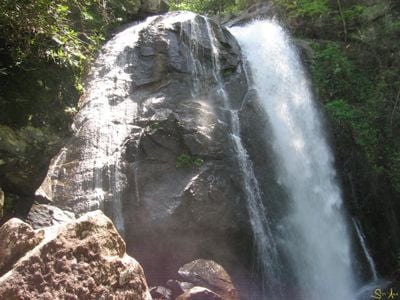
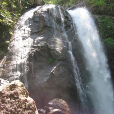
South Mountains State Park is the largest protected area in North Carolina, covering 18,000 acres with mountains reaching around 3,000 feet in elevation and featuring an 80-foot waterfall along Jacob Fork River. The terrain includes forests, streams, and open ridges that create a diverse landscape for exploration.

History

The North Carolina government established this park in 1975 to protect 18,000 acres of natural mountain terrain in the region between the Appalachian Mountains and their foothills. This designation was a key effort to preserve the landscape for future generations.

Culture

The park draws people seeking a connection to the natural rhythm of the mountains and the sound of flowing water. It serves as a place where visitors experience the landscape that has shaped life in this part of North Carolina for generations.

Practical

The park offers an extensive network of trails for hiking, horseback riding, and mountain biking, along with camping sites that have electrical hookups for extended stays. Visitors should know that mountain trails vary in difficulty and conditions change with the seasons.

Did you know?

The Jacob Fork River within the park contains special trout waters where anglers can fish in designated catch-and-release sections during specific seasons. These waters offer a quiet way to experience the park's river landscapes in detail.

Location
Inception
1975
Opening Hours
Monday-Sunday 08:00-18:00
GPS coordinates
35.59860,-81.65970
Latest update
December 9, 2025 18:43

AroundUs brings together thousands of curated places, local tips, and hidden gems, enriched daily by 60,000 contributors worldwide. Discover all places nearby (Burke County).

Around this place
United States of America

Joara

22.6 km
Lake James State Park
United States of America

Lake James State Park

25.6 km
High Shoals Falls
United States of America

High Shoals Falls

2.2 km
Waldensian Presbyterian Church
United States of America

Waldensian Presbyterian Church

18.3 km
Quaker Meadows
United States of America

Quaker Meadows

18.5 km
Creekside
United States of America

Creekside

15.8 km
Magnolia Place
United States of America

Magnolia Place

13.6 km
Franklin Pierce Tate House
United States of America

Franklin Pierce Tate House

16.1 km
Burke County Courthouse
United States of America

Burke County Courthouse

16.5 km
Tate House
United States of America

Tate House

16.4 km
Carson-Andrews Mill and Ben F.W. Andrews House
United States of America

Carson-Andrews Mill and Ben F.W. Andrews House

26.4 km
Bellevue
United States of America

Bellevue

20.9 km
Gaston Chapel
United States of America

Gaston Chapel

16.8 km
Valdese Elementary School
United States of America

Valdese Elementary School

18.3 km
Reinhardt-Craig House, Kiln and Pottery Shop
United States of America

Reinhardt-Craig House, Kiln and Pottery Shop

21.2 km
Mountain View
United States of America

Mountain View

16.1 km
Gaither House
United States of America

Gaither House

16.2 km
John Lattimore House
United States of America

John Lattimore House

17.3 km
John Alexander Lackey House
United States of America

John Alexander Lackey House

19.6 km
Hunting Creek Railroad Bridge
United States of America

Hunting Creek Railroad Bridge

17 km
Morganton Downtown Historic District
United States of America

Morganton Downtown Historic District

16.6 km
Alphonse Calhoun Avery House
United States of America

Alphonse Calhoun Avery House

16.9 km
Jean-Pierre Auguste Dalmas House
United States of America

Jean-Pierre Auguste Dalmas House

19.7 km
Gilboa Methodist Church
United States of America

Gilboa Methodist Church

11.8 km
Dr. Joseph Bennett Riddle House
United States of America

Dr. Joseph Bennett Riddle House

16 km
Avery Avenue School
United States of America

Avery Avenue School

16.8 km
Jacob Forney Jr. House
United States of America

Jacob Forney Jr. House

23.1 km
Melton-Davis House
United States of America

Melton-Davis House

23.2 km
Show the full map
« South Mountains State Park - State park in Burke County, United States » is provided by Around Us (aroundus.com). Images and texts are derived from Wikimedia project under a Creative Commons license. You are allowed to copy, distribute, and modify copies of this page, under the conditions set by the license, as long as this note is clearly visible.

Discover hidden gems everywhere you go!

From secret cafés to breathtaking viewpoints, skip the crowded tourist spots and find places that match your style. Our app makes it easy with voice search, smart filtering, route optimization, and insider tips from travelers worldwide. Download now for the complete mobile experience.

Around Us App Screenshot

A unique approach to discovering new places

Le Figaro

All the places worth exploring

France Info

A tailor-made excursion in just a few clicks

20 Minutes

Around Us
Travel Guide & Maps
Download

Send to your phone

QR Code
1

Open the camera app on your mobile.

2

Point at the QR code with your camera. A notification will appear.

3

Tap the notification to open the link.