Enable Location

We need your location to show you interesting places around you

Discover nearby places

Find interesting locations and hidden gems around you

Precise directions

Get accurate directions and distances to places

Your location is never shared with other users. It's only used when you tap the location button.

Thomas FitzSimons High School

Log in to your account

Start exploring — it's free

Trusted by 62,331 travelers worldwide

Continue with Google
Continue with Apple
or

We will send you a code to connect

By continuing, you accept our Terms and Conditions and our Privacy Policy

Check your inbox

We've sent a pincode in your inbox. Please enter the code below.

Thomas FitzSimons High School, high school in Pennsylvania, United States

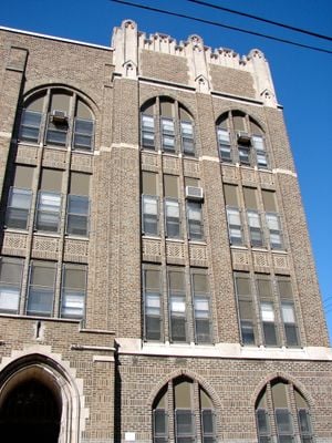
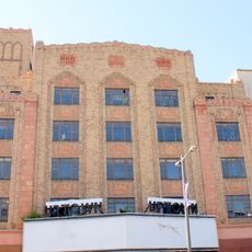
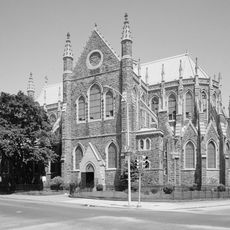
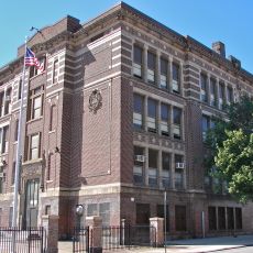
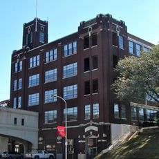
Thomas FitzSimons High School is a high school building in Philadelphia's Strawberry Mansion neighborhood, designed in Late Gothic Revival style with tall windows and decorative stonework. The structure displays characteristic architectural details and occupies a notable position within the residential area.

The building was constructed in 1926 by architect Irwin T. Catharine in Late Gothic Revival style and served for decades as a boys' school within the public system. It was added to the National Register of Historic Places in 1988 and finally closed in 2013, with its students transferred to other schools.

The building is named after Thomas FitzSimons, a signer of the US Constitution, connecting it to the nation's founding. This historical connection shapes how residents view the structure as a landmark tied to American origins.

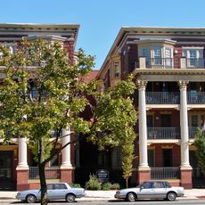
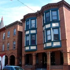
The building sits on West Cumberland Street in the Strawberry Mansion neighborhood and is easily walkable, located among other historic structures. The exterior can be viewed from the street with good visibility of the Gothic architectural details, particularly the tall windows and stonework.

The building briefly housed KIPP Du Bois Collegiate Academy and was historically connected to feeder elementary schools such as Thomas M. Peirce Elementary, creating a natural pathway for young students. These feeder schools made the institution an important part of the neighborhood's educational network.

The community of curious travelers

AroundUs brings together thousands of curated places, local tips, and hidden gems, enriched daily by 60,000 contributors worldwide.

Start exploring
Location
GPS coordinates
39.99361,-75.17528
Latest update
February 9, 2026 08:23
Around this place
Baker Bowl
United States of America

Baker Bowl

1.7 km
Laurel Hill Cemetery
United States of America

Laurel Hill Cemetery

1.5 km
Strawberry Mansion
United States of America

Strawberry Mansion

1.3 km
Uptown Theatre
United States of America

Uptown Theatre

1.8 km
Wagner Free Institute of Science
United States of America

Wagner Free Institute of Science

1.8 km
Strawberry Mansion Bridge
United States of America

Strawberry Mansion Bridge

1.6 km
The Medicine Man
United States of America

The Medicine Man

974 m
United States of America

Odd Fellows Cemetery

787 m
Church of the Advocate
United States of America

Church of the Advocate

1.3 km
Woodford
United States of America

Woodford

1.1 km
Mount Peace Cemetery
United States of America

Mount Peace Cemetery

779 m
Chamounix
United States of America

Chamounix

1.4 km
Most Precious Blood Roman Catholic Church, Rectory and Parochial School
United States of America

Most Precious Blood Roman Catholic Church, Rectory and Parochial School

856 m
The Lilacs
United States of America

The Lilacs

1.9 km
Ormiston Mansion
United States of America

Ormiston Mansion

1.9 km
John Greenleaf Whittier School
United States of America

John Greenleaf Whittier School

963 m
St. Joseph's House for Homeless Industrious Boys
United States of America

St. Joseph's House for Homeless Industrious Boys

1.9 km
Randolph House
United States of America

Randolph House

1.7 km
Gen. John F. Reynolds School
United States of America

Gen. John F. Reynolds School

1.8 km
Rudolph Walton School
United States of America

Rudolph Walton School

207 m
Henry O. Tanner House
United States of America

Henry O. Tanner House

869 m
Dobson Mills
United States of America

Dobson Mills

1.9 km
Union Methodist Episcopal Church
United States of America

Union Methodist Episcopal Church

1.1 km
American Railway Express Company Garage
United States of America

American Railway Express Company Garage

1.3 km
McDowell Memorial Presbyterian Church
United States of America

McDowell Memorial Presbyterian Church

1.6 km
Plaza Apartments
United States of America

Plaza Apartments

1.2 km
Houses at 1907–1951 N. 32nd St.
United States of America

Houses at 1907–1951 N. 32nd St.

1.2 km
Edward G. Budd Manufacturing Company Building
United States of America

Edward G. Budd Manufacturing Company Building

1.8 km
Show the full map
« Thomas FitzSimons High School - high school in Pennsylvania, United States » is provided by Around Us (aroundus.com). Images and texts are derived from Wikimedia project under a Creative Commons license. You are allowed to copy, distribute, and modify copies of this page, under the conditions set by the license, as long as this note is clearly visible.

Discover hidden gems everywhere you go!

From secret cafés to breathtaking viewpoints, skip the crowded tourist spots and find places that match your style. Our app makes it easy with voice search, smart filtering, route optimization, and insider tips from travelers worldwide. Download now for the complete mobile experience.

Around Us App Screenshot

A unique approach to discovering new places

Le Figaro

All the places worth exploring

France Info

A tailor-made excursion in just a few clicks

20 Minutes

Around Us
Travel Guide & Maps
Download

Send to your phone

QR Code
1

Open the camera app on your mobile.

2

Point at the QR code with your camera. A notification will appear.

3

Tap the notification to open the link.