Enable Location

We need your location to show you interesting places around you

Discover nearby places

Find interesting locations and hidden gems around you

Precise directions

Get accurate directions and distances to places

Your location is never shared with other users. It's only used when you tap the location button.

Thomas Ranck Round Barn

Log in to your account

Start exploring — it's free

Trusted by 61,582 travelers worldwide

Continue with Google
Continue with Apple
or

We will send you a code to connect

By continuing, you accept our Terms and Conditions and our Privacy Policy

Check your inbox

We've sent a pincode in your inbox. Please enter the code below.

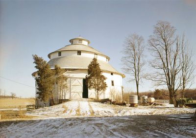
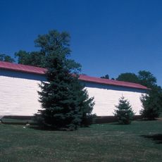
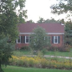
Thomas Ranck Round Barn, Agricultural round barn in Waterloo Township, Indiana, United States

Description

The Thomas Ranck Round Barn is an agricultural structure with three stacked circular levels forming a tower-like shape. Inside you find storage sections, grain areas, and a hayloft, all accessed from the earthen ramp on the western side.

History

It was built in 1904 by architect Isaac McNammee as part of an agricultural innovation movement in the Midwest. The structure earned official recognition in 1983 through its listing on the National Register of Historic Places.

Culture

The design reflects an experimental approach that farming families embraced to rethink how they organized their work and stored crops. Visitors can see how this approach shaped the way agricultural buildings were imagined in the early 1900s.

Practical

The site is accessible via a clear entrance pathway, making it easy to approach from the main road. Plan to spend time exploring the exterior and surroundings, as the setting is rural and somewhat removed from other attractions.

Did you know?

The roof structure is remarkable for having no interior support columns, achieved through skilled carpentry using thin wooden members. This engineering approach demonstrates an innovative solution that allowed for open interior spaces without obstructions.

Location
GPS coordinates
39.71389,-85.04444
Latest update
December 14, 2025 13:03

AroundUs brings together thousands of curated places, local tips, and hidden gems, enriched daily by 60,000 contributors worldwide. Discover all places nearby (Indiana).

Around this place
Richmond High School
United States of America

Richmond High School

17.1 km
Whitewater Memorial State Park
United States of America

Whitewater Memorial State Park

13 km
Wayne County Courthouse
United States of America

Wayne County Courthouse

17.9 km
Elmhurst
United States of America

Elmhurst

12.6 km
Richmond Art Museum
United States of America

Richmond Art Museum

17.3 km
Canal House
United States of America

Canal House

11.6 km
Old Richmond Historic District
United States of America

Old Richmond Historic District

17.8 km
Forest Hills Country Club
United States of America

Forest Hills Country Club

18 km
Bethel A.M.E. Church
United States of America

Bethel A.M.E. Church

17.9 km
Mary Birdsall House
United States of America

Mary Birdsall House

17.8 km
Union County Courthouse
United States of America

Union County Courthouse

13.1 km
Oliver P. Morton House
United States of America

Oliver P. Morton House

12.1 km
Fayette County Courthouse
United States of America

Fayette County Courthouse

11.6 km
Centerville Historic District
United States of America

Centerville Historic District

12.3 km
Earlham College Observatory
United States of America

Earlham College Observatory

16.6 km
Longwood Covered Bridge
United States of America

Longwood Covered Bridge

8.5 km
Liberty Courthouse Square Historic District
United States of America

Liberty Courthouse Square Historic District

13.1 km
Cambridge City Historic District
United States of America

Cambridge City Historic District

15.3 km
Beechwood
United States of America

Beechwood

10.2 km
Conklin-Montgomery House
United States of America

Conklin-Montgomery House

15 km
Lewis Jones House
United States of America

Lewis Jones House

14.3 km
Richmond Gas Company Building
United States of America

Richmond Gas Company Building

17.9 km
Liberty Residential Historic District
United States of America

Liberty Residential Historic District

13.3 km
David Worth Dennis House
United States of America

David Worth Dennis House

17.2 km
Lackey-Overbeck House
United States of America

Lackey-Overbeck House

14.8 km
Witt-Champe-Myers House
United States of America

Witt-Champe-Myers House

17.2 km
William Lowry House
United States of America

William Lowry House

12.3 km
Morrison-Reeves Library
United States of America

Morrison-Reeves Library

18.2 km
Show the full map
« Thomas Ranck Round Barn - Agricultural round barn in Waterloo Township, Indiana, United States » is provided by Around Us (aroundus.com). Images and texts are derived from Wikimedia project under a Creative Commons license. You are allowed to copy, distribute, and modify copies of this page, under the conditions set by the license, as long as this note is clearly visible.

Discover hidden gems everywhere you go!

From secret cafés to breathtaking viewpoints, skip the crowded tourist spots and find places that match your style. Our app makes it easy with voice search, smart filtering, route optimization, and insider tips from travelers worldwide. Download now for the complete mobile experience.

Around Us App Screenshot

A unique approach to discovering new places

Le Figaro

All the places worth exploring

France Info

A tailor-made excursion in just a few clicks

20 Minutes

Around Us
Travel Guide & Maps
Download

Send to your phone

QR Code
1

Open the camera app on your mobile.

2

Point at the QR code with your camera. A notification will appear.

3

Tap the notification to open the link.