Enable Location

We need your location to show you interesting places around you

Discover nearby places

Find interesting locations and hidden gems around you

Precise directions

Get accurate directions and distances to places

Your location is never shared with other users. It's only used when you tap the location button.

Titusville Commercial District

Log in to your account

Start exploring — it's free

Trusted by 61,652 travelers worldwide

Continue with Google
Continue with Apple
or

We will send you a code to connect

By continuing, you accept our Terms and Conditions and our Privacy Policy

Check your inbox

We've sent a pincode in your inbox. Please enter the code below.

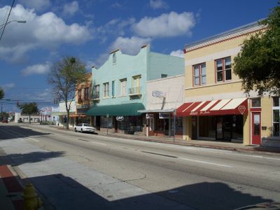
Titusville Commercial District, Historic district in downtown Titusville, Florida.

Description

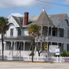
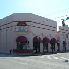
The Titusville Commercial District is a historic area in downtown Titusville that spans several blocks between Julia Street, Hopkins Avenue, Main Street, and Indian River Avenue. The district contains 21 historic buildings representing different architectural styles and periods.

History

The district gained recognition on the National Register of Historic Places in 1990, marking official protection for its historic structures. The buildings here document the growth of this coastal settlement over different time periods.

Culture

Local merchants maintain traditional storefronts that reflect the commercial heritage of this coastal settlement. You can see how shop owners continue to use and display their storefronts in the way they have for generations.

Practical

You can reach this district via US Highway 1, with public parking available near the corner of Main Street and Washington Avenue. The flat terrain makes it easy to walk through the blocks and view the buildings from the street.

Did you know?

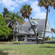
The town's name came about through an unusual event when Colonel Henry Theodore Titus established the first hotel and the place gained its name through a dominoes game. This story reveals how the settlement's beginning was tied to the character of its early founder.

Location
GPS coordinates
28.61197,-80.80704
Latest update
December 14, 2025 16:46

AroundUs brings together thousands of curated places, local tips, and hidden gems, enriched daily by 60,000 contributors worldwide. Discover all places nearby (Florida).

Around this place
Vehicle Assembly Building
United States of America

Vehicle Assembly Building

15.5 km
Crawler-transporter
United States of America

Crawler-transporter

15.1 km
Kennedy Space Center Visitor Complex
United States of America

Kennedy Space Center Visitor Complex

15.7 km

Space Mirror Memorial
United States of America

Space Mirror Memorial

15.6 km
Playalinda Beach
United States of America

Playalinda Beach

17.4 km
Windover Archaeological Site
United States of America

Windover Archaeological Site

8.9 km
Rocco A. Petrone Launch Control Center
United States of America

Rocco A. Petrone Launch Control Center

15.7 km
Merritt Island National Wildlife Refuge
United States of America

Merritt Island National Wildlife Refuge

17.3 km
Operations and Checkout Building
United States of America

Operations and Checkout Building

18.5 km
Valiant Air Command Warbird Museum
United States of America

Valiant Air Command Warbird Museum

10.1 km
Space Shuttle Atlantis
United States of America

Space Shuttle Atlantis

15.7 km
NASA Causeway
United States of America

NASA Causeway

10 km
A. Max Brewer Bridge
United States of America

A. Max Brewer Bridge

1.2 km
Launch Complex 39 Press Site
United States of America

Launch Complex 39 Press Site

16.2 km
American Police Hall of Fame & Museum
United States of America

American Police Hall of Fame & Museum

9.7 km
American Space Museum
United States of America

American Space Museum

222 m
Pritchard House
United States of America

Pritchard House

202 m
John F. Kennedy Space Center MPS
United States of America

John F. Kennedy Space Center MPS

15.5 km
Spell House
United States of America

Spell House

1.1 km
Judge George Robbins House
United States of America

Judge George Robbins House

501 m
Wager House
United States of America

Wager House

440 m
Old Brevard County Courthouse
United States of America

Old Brevard County Courthouse

374 m
Titusville MPS
United States of America

Titusville MPS

2.6 km
Emma Parrish Theatre
United States of America

Emma Parrish Theatre

167 m
Jay-Jay Bridge
United States of America

Jay-Jay Bridge

4.3 km
Puckett Creek
United States of America

Puckett Creek

3.8 km
Cow Pen Creek
United States of America

Cow Pen Creek

7.7 km
Show the full map
« Titusville Commercial District - Historic district in downtown Titusville, Florida » is provided by Around Us (aroundus.com). Images and texts are derived from Wikimedia project under a Creative Commons license. You are allowed to copy, distribute, and modify copies of this page, under the conditions set by the license, as long as this note is clearly visible.

Discover hidden gems everywhere you go!

From secret cafés to breathtaking viewpoints, skip the crowded tourist spots and find places that match your style. Our app makes it easy with voice search, smart filtering, route optimization, and insider tips from travelers worldwide. Download now for the complete mobile experience.

Around Us App Screenshot

A unique approach to discovering new places

Le Figaro

All the places worth exploring

France Info

A tailor-made excursion in just a few clicks

20 Minutes

Around Us
Travel Guide & Maps
Download

Send to your phone

QR Code
1

Open the camera app on your mobile.

2

Point at the QR code with your camera. A notification will appear.

3

Tap the notification to open the link.