Enable Location

We need your location to show you interesting places around you

Discover nearby places

Find interesting locations and hidden gems around you

Precise directions

Get accurate directions and distances to places

Your location is never shared with other users. It's only used when you tap the location button.

Vietnam Memorial Bridge

Log in to your account

Start exploring — it's free

Trusted by 61,899 travelers worldwide

Continue with Google
Continue with Apple
or

We will send you a code to connect

By continuing, you accept our Terms and Conditions and our Privacy Policy

Check your inbox

We've sent a pincode in your inbox. Please enter the code below.

Vietnam Memorial Bridge

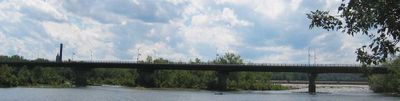
Vietnam Memorial Bridge, Girder bridge across Connecticut River in Massachusetts, United States.

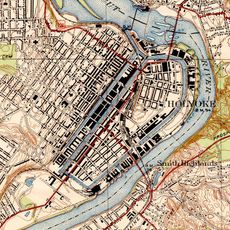
The Vietnam Memorial Bridge is a steel girder bridge carrying Route 116 across the Connecticut River between South Hadley and Holyoke. The structure accommodates both cars and pedestrians traveling between these two towns along this vital crossing.

The original bridge opened in 1889, built by eastern steel manufacturers to connect the growing communities on both sides of the river. The current structure, completed in 1990, was rebuilt to meet modern traffic demands and replace the aging original.

The structure serves as a memorial to those who served during the Vietnam War, a dedication that shapes how locals think about this crossing. The name reflects the community's effort to honor military service through everyday infrastructure.

The bridge has sidewalks for walkers but carries steady vehicle traffic, so stay alert while crossing. Early morning or late afternoon offers quieter passage if you prefer less traffic noise during your visit.

A preserved sign from the 1889 original bridge remains on display near the current structure, creating a physical link between two eras. This relic offers a glimpse into how engineering and materials have changed over more than a century.

The community of curious travelers

AroundUs brings together thousands of curated places, local tips, and hidden gems, enriched daily by 60,000 contributors worldwide.

Start exploring
Location
Inception
1990
GPS coordinates
42.21170,-72.59610
Latest update
December 14, 2025 11:41
Around this place
Mount Tom
United States of America

Mount Tom

5.4 km
Dinosaur Footprints Reservation
United States of America

Dinosaur Footprints Reservation

4 km
Holyoke Canal System
United States of America

Holyoke Canal System

483 m
Mackenzie Stadium
United States of America

Mackenzie Stadium

2.5 km
Holyoke Heritage State Park
United States of America

Holyoke Heritage State Park

1.1 km
South Hadley Canal
United States of America

South Hadley Canal

1.5 km
Wistariahurst
United States of America

Wistariahurst

1.9 km
Victory Theatre
United States of America

Victory Theatre

1.3 km
Holyoke City Hall
United States of America

Holyoke City Hall

1.1 km
United States of America

Holyoke Merry-Go-Round

941 m
Edward Bellamy House
United States of America

Edward Bellamy House

6.3 km
Mount Holyoke College Art Museum
United States of America

Mount Holyoke College Art Museum

5.4 km
Willimansett Bridge
United States of America

Willimansett Bridge

1.9 km
Mount Holyoke College Botanic Garden
United States of America

Mount Holyoke College Botanic Garden

5.4 km
United States of America

Churchill, Holyoke, Massachusetts

2 km
Joseph Allen Skinner Museum
United States of America

Joseph Allen Skinner Museum

1.9 km
Clovis Robert Block
United States of America

Clovis Robert Block

1.6 km
Woodbridge Street Historic District
United States of America

Woodbridge Street Historic District

6.2 km
Caledonia Building
United States of America

Caledonia Building

1.1 km
Veterans Park (Holyoke, Massachusetts)
United States of America

Veterans Park (Holyoke, Massachusetts)

1.1 km
Carreau Block
United States of America

Carreau Block

3.3 km
Hadley Falls Company Housing District
United States of America

Hadley Falls Company Housing District

1.1 km
Friedrich Block
United States of America

Friedrich Block

1.9 km
Chapin School
United States of America

Chapin School

3.2 km
United States Post Office–South Hadley Main
United States of America

United States Post Office–South Hadley Main

5.6 km
United States Post Office–Holyoke Main
United States of America

United States Post Office–Holyoke Main

1.3 km
North High Street Historic District
United States of America

North High Street Historic District

1 km
Joseph E. Muller Bridge
United States of America

Joseph E. Muller Bridge

1.1 km
Show the full map
« Vietnam Memorial Bridge - Girder bridge across Connecticut River in Massachusetts, United States » is provided by Around Us (aroundus.com). Images and texts are derived from Wikimedia project under a Creative Commons license. You are allowed to copy, distribute, and modify copies of this page, under the conditions set by the license, as long as this note is clearly visible.

Discover hidden gems everywhere you go!

From secret cafés to breathtaking viewpoints, skip the crowded tourist spots and find places that match your style. Our app makes it easy with voice search, smart filtering, route optimization, and insider tips from travelers worldwide. Download now for the complete mobile experience.

Around Us App Screenshot

A unique approach to discovering new places

Le Figaro

All the places worth exploring

France Info

A tailor-made excursion in just a few clicks

20 Minutes

Around Us
Travel Guide & Maps
Download

Send to your phone

QR Code
1

Open the camera app on your mobile.

2

Point at the QR code with your camera. A notification will appear.

3

Tap the notification to open the link.