Holyoke Canal System

Log in to your account

AroundUs is a community-driven map of interesting places, built by curious explorers like you. It grows with every review, story, and photo you share.
Connect to save your favorite spots, contribute locations, and create personalized routes.
Continue with Google
Continue with Apple
Continue with X
Continue with Facebook
Continue with email
By continuing, you accept our Terms and Conditions and our Privacy Policy
Create an account
Add to collection
Map
Suggest a change
Share

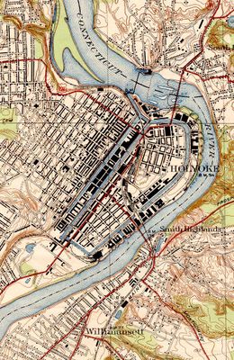
Holyoke Canal System, Historic power canal system in Holyoke, Massachusetts.

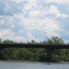
The Holyoke Canal System comprises three main waterways at different elevations running through the industrial district, fed by the Connecticut River. These channels carry water through the city's core, with numerous bridges crossing them to connect neighborhoods and recreational spaces.

Construction began in 1847 to harness water power from the Connecticut River for industrial mills and factories. This project turned Holyoke into one of New England's major manufacturing hubs during the 1800s.

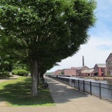
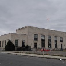
The canal system shaped Holyoke's identity as an industrial city where textile mills and factories became the heart of community life. Walking through the downtown area today, you can see the large brick mill buildings that still line the waterways and reflect the city's working heritage.

The best way to explore the canal district is on foot using the walking paths and public spaces that line the waterways. Starting from downtown gives you easy access to parking and clear starting points for routes along the banks.

The system undergoes seasonal draining in spring and fall, a maintenance practice that has continued since its early days. These rare moments reveal the canal bed structure that normally stays hidden beneath the water.

Location: Massachusetts

GPS coordinates: 42.20860,-72.60020

Latest update: December 10, 2025 16:28

Photos
Around this place
Mount Tom
United States of America

Mount Tom

5.4 km
Dinosaur Footprints Reservation
United States of America

Dinosaur Footprints Reservation

4.1 km
Mackenzie Stadium
United States of America

Mackenzie Stadium

2 km
Holyoke Heritage State Park
United States of America

Holyoke Heritage State Park

663 m
South Hadley Canal
United States of America

South Hadley Canal

1.5 km
Wistariahurst
United States of America

Wistariahurst

1.5 km
Victory Theatre
United States of America

Victory Theatre

830 m
Holyoke City Hall
United States of America

Holyoke City Hall

672 m
United States of America

Holyoke Merry-Go-Round

469 m
Edward Bellamy House
United States of America

Edward Bellamy House

6 km
Mount Holyoke College Art Museum
United States of America

Mount Holyoke College Art Museum

5.8 km
Willimansett Bridge
United States of America

Willimansett Bridge

1.5 km
Vietnam Memorial Bridge
United States of America

Vietnam Memorial Bridge

483 m
Mount Holyoke College Botanic Garden
United States of America

Mount Holyoke College Botanic Garden

5.9 km
United States of America

Churchill, Holyoke, Massachusetts

1.5 km
Joseph Allen Skinner Museum
United States of America

Joseph Allen Skinner Museum

1.5 km
Thomas D. Page House
United States of America

Thomas D. Page House

6.1 km
Clovis Robert Block
United States of America

Clovis Robert Block

1.2 km
Caledonia Building
United States of America

Caledonia Building

614 m
Veterans Park (Holyoke, Massachusetts)
United States of America

Veterans Park (Holyoke, Massachusetts)

669 m
Carreau Block
United States of America

Carreau Block

2.8 km
Hadley Falls Company Housing District
United States of America

Hadley Falls Company Housing District

1.4 km
Friedrich Block
United States of America

Friedrich Block

1.5 km
Chapin School
United States of America

Chapin School

2.8 km
United States Post Office–South Hadley Main
United States of America

United States Post Office–South Hadley Main

6 km
United States Post Office–Holyoke Main
United States of America

United States Post Office–Holyoke Main

856 m
North High Street Historic District
United States of America

North High Street Historic District

582 m
Joseph E. Muller Bridge
United States of America

Joseph E. Muller Bridge

1 km
Show the full map
Reviews

Visited this place? Tap the stars to rate it and share your experience / photos with the community! Try now! You can cancel it anytime.

« Holyoke Canal System - Historic power canal system in Holyoke, Massachusetts » is provided by Around Us (aroundus.com). Images and texts are derived from Wikimedia project under a Creative Commons license. You are allowed to copy, distribute, and modify copies of this page, under the conditions set by the license, as long as this note is clearly visible.

Discover hidden gems everywhere you go!

From secret cafés to breathtaking viewpoints, skip the crowded tourist spots and find places that match your style. Our app makes it easy with voice search, smart filtering, route optimization, and insider tips from travelers worldwide. Download now for the complete mobile experience.

Around Us App Screenshot

A unique approach to discovering new places

Le Figaro

All the places worth exploring

France Info

A tailor-made excursion in just a few clicks

20 Minutes