Enable Location

We need your location to show you interesting places around you

Discover nearby places

Find interesting locations and hidden gems around you

Precise directions

Get accurate directions and distances to places

Your location is never shared with other users. It's only used when you tap the location button.

Vine Street Expressway Bridge

Log in to your account

Start exploring — it's free

Trusted by 63,120 travelers worldwide

Continue with Google
Continue with Apple
or

We will send you a code to connect

By continuing, you accept our Terms and Conditions and our Privacy Policy

Check your inbox

We've sent a pincode in your inbox. Please enter the code below.

Vine Street Expressway Bridge
Discussion Reviews 1 Photos
2k Popularity

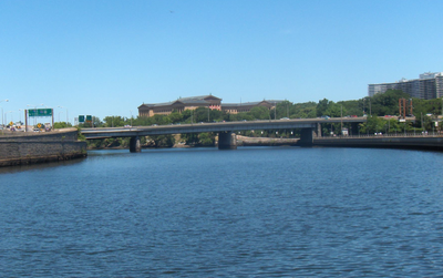
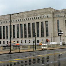
Vine Street Expressway Bridge, Road bridge in Center City Philadelphia, United States.

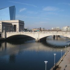
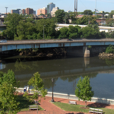
The Vine Street Expressway Bridge is a steel structure spanning the Schuylkill River in Philadelphia with three main sections supported by two piers set in the water. It connects Center City with western neighborhoods and serves as a key interchange in the regional highway system.

The bridge was built in 1959 to address growing traffic demands and improve connections between Philadelphia's eastern and western sides. Its completion marked a shift in the city's infrastructure development during the postwar era.

The bridge forms an integral part of Interstate 676, connecting Philadelphia's central business district with cultural landmarks including the Philadelphia Museum of Art.

The structure carries traffic daily and is used by thousands of vehicles shuttling between the city's two sides. Visitors should expect heavy traffic, especially during morning and evening rush hours.

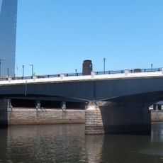
The bridge simultaneously spans multiple layers of traffic infrastructure, including railway tracks and a separate ramp, making it a complex engineering feat. This multi-level arrangement allows several transportation networks to coexist in a tight space.

The community of curious travelers

AroundUs brings together thousands of curated places, local tips, and hidden gems, enriched daily by 60,000 contributors worldwide.

Start exploring
Location
Inception
1959
Official opening
1959
GPS coordinates
39.96020,-75.18000
Latest update
December 14, 2025 09:41
Around this place
Rocky Steps
United States of America

Rocky Steps

523 m
Philadelphia Museum of Art
United States of America

Philadelphia Museum of Art

638 m
Barnes Foundation
United States of America

Barnes Foundation

624 m
Franklin Institute
United States of America

Franklin Institute

595 m
Charioteer of Delphi
Greece

Charioteer of Delphi

584 m
Rodin Museum
United States of America

Rodin Museum

554 m
Cira Centre
United States of America

Cira Centre

382 m
Eakins Oval
United States of America

Eakins Oval

433 m
Benjamin Franklin National Memorial
United States of America

Benjamin Franklin National Memorial

643 m
Cira Centre South
United States of America

Cira Centre South

395 m
Pennsylvania Railroad World War II Memorial
United States of America

Pennsylvania Railroad World War II Memorial

521 m
PECO Building
United States of America

PECO Building

644 m
United States Post Office-Main Branch
United States of America

United States Post Office-Main Branch

541 m
Spring Garden Street Bridge
United States of America

Spring Garden Street Bridge

546 m
Chief Justice John Marshall
United States of America

Chief Justice John Marshall

687 m
Rocky Statue
United States of America

Rocky Statue

553 m
Market Street Bridge
United States of America

Market Street Bridge

646 m
The Ideal Scout
United States of America

The Ideal Scout

427 m
Park Towne Place
United States of America

Park Towne Place

236 m
John F. Kennedy Boulevard Bridge
United States of America

John F. Kennedy Boulevard Bridge

534 m
West River Drive Bridge
United States of America

West River Drive Bridge

583 m
Board of Education Building
United States of America

Board of Education Building

402 m
West Philadelphia Elevated
United States of America

West Philadelphia Elevated

428 m
Larkin–Belber Building
United States of America

Larkin–Belber Building

563 m
Equestrian statue of Anthony Wayne
United States of America

Equestrian statue of Anthony Wayne

510 m
The Spirit of Transportation
United States of America

The Spirit of Transportation

501 m
Equestrian statue of Joan of Arc
United States of America

Equestrian statue of Joan of Arc

705 m
John Shedwick Development Houses
United States of America

John Shedwick Development Houses

301 m
Show the full map
Reviews
Share your experience

No review yet

Discussions
Start a discussion...

No discussion yet

« Vine Street Expressway Bridge - Road bridge in Center City Philadelphia, United States » is provided by Around Us (aroundus.com). Images and texts are derived from Wikimedia project under a Creative Commons license. You are allowed to copy, distribute, and modify copies of this page, under the conditions set by the license, as long as this note is clearly visible.

Discover hidden gems everywhere you go!

From secret cafés to breathtaking viewpoints, skip the crowded tourist spots and find places that match your style. Our app makes it easy with voice search, smart filtering, route optimization, and insider tips from travelers worldwide. Download now for the complete mobile experience.

Around Us App Screenshot

A unique approach to discovering new places

Le Figaro

All the places worth exploring

France Info

A tailor-made excursion in just a few clicks

20 Minutes

Around Us
Travel Guide & Maps
Download

Send to your phone

QR Code
1

Open the camera app on your mobile.

2

Point at the QR code with your camera. A notification will appear.

3

Tap the notification to open the link.