West Chester State College Quadrangle Historic District

Log in to your account

AroundUs is a community-driven map of interesting places, built by curious explorers like you. It grows with every review, story, and photo you share.
Connect to save your favorite spots, contribute locations, and create personalized routes.
Continue with Google
Continue with Apple
Continue with X
Continue with Facebook
Continue with email
By continuing, you accept our Terms and Conditions and our Privacy Policy
Create an account
Add to collection
Map
Suggest a change
Share

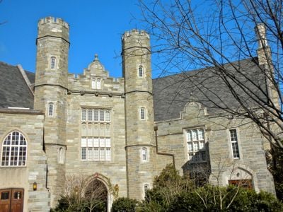
West Chester State College Quadrangle Historic District, Historic academic district at West Chester University, Pennsylvania, USA

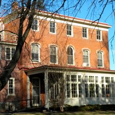
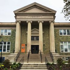
The West Chester State College Quadrangle Historic District is an academic campus area in Pennsylvania with five buildings constructed between 1891 and 1940 surrounding a central courtyard. The structures display various architectural styles and define the core of the campus through their arrangement around the shared quad.

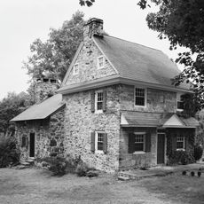
The site developed between 1891 and 1940 as the university built out its infrastructure and systematically expanded its academic spaces. Some of the original buildings used stone from local quarries in Chester County, reflecting their connection to the region.

The quad demonstrates how the university organized its academic spaces around a central courtyard to create a gathering place for students and visitors. This arrangement follows a classic campus tradition of buildings grouped around a shared open space.

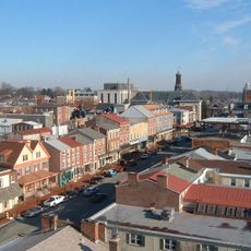
The district sits between South High Street and South Church Street and connects major campus buildings, making it easily accessible on foot. Visitors can explore the quad and view the surrounding buildings from outside to understand the architecture and layout of this historic area.

The Frederick Douglass Institute on the grounds commemorates the civil rights leader who delivered his final public speech here in 1895. This connection to an important moment in American history often surprises visitors.

Location: West Chester

Inception: 1891

GPS coordinates: 39.95222,-75.59861

Latest update: December 14, 2025 14:43

Photos
Around this place
American Helicopter Museum
United States of America

American Helicopter Museum

4.7 km
Chester County Courthouse
United States of America

Chester County Courthouse

1 km
Warner Theatre
United States of America

Warner Theatre

1.1 km
Butler House
United States of America

Butler House

336 m
Bank of Chester County
United States of America

Bank of Chester County

1.1 km
Farmers and Mechanics Building
United States of America

Farmers and Mechanics Building

982 m
Sharples Separator Works
United States of America

Sharples Separator Works

1.5 km
West Chester Downtown Historic District
United States of America

West Chester Downtown Historic District

1.1 km
Philips Memorial Building
United States of America

Philips Memorial Building

0 m
Barclay House
United States of America

Barclay House

1.9 km
Cope's Bridge
United States of America

Cope's Bridge

4.9 km
Lenape Bridge
United States of America

Lenape Bridge

4.9 km
West Chester Boarding School for Boys
United States of America

West Chester Boarding School for Boys

1.5 km
Sharples Homestead
United States of America

Sharples Homestead

656 m
Old Library
United States of America

Old Library

0 m
Collins Mansion
United States of America

Collins Mansion

2.6 km
William Everhart Buildings
United States of America

William Everhart Buildings

989 m
Strode's Mill
United States of America

Strode's Mill

3.1 km
New Century Clubhouse
United States of America

New Century Clubhouse

363 m
Sharpless Homestead
United States of America

Sharpless Homestead

3.8 km
County Bridge No. 148
United States of America

County Bridge No. 148

4.6 km
William J. Barnard Residence
United States of America

William J. Barnard Residence

5 km
East Bradford Boarding School for Boys
United States of America

East Bradford Boarding School for Boys

3 km
Strode's Mill Historic District
United States of America

Strode's Mill Historic District

3.1 km
Daniel Davis House and Barn
United States of America

Daniel Davis House and Barn

4.4 km
Taylor-Cope Historic District
United States of America

Taylor-Cope Historic District

4.2 km
Worth-Jefferis Rural Historic District
United States of America

Worth-Jefferis Rural Historic District

5 km
Joseph Rothrock House
United States of America

Joseph Rothrock House

1.6 km
Show the full map
Reviews

Visited this place? Tap the stars to rate it and share your experience / photos with the community! Try now! You can cancel it anytime.

« West Chester State College Quadrangle Historic District - Historic academic district at West Chester University, Pennsylvania, USA » is provided by Around Us (aroundus.com). Images and texts are derived from Wikimedia project under a Creative Commons license. You are allowed to copy, distribute, and modify copies of this page, under the conditions set by the license, as long as this note is clearly visible.

Discover hidden gems everywhere you go!

From secret cafés to breathtaking viewpoints, skip the crowded tourist spots and find places that match your style. Our app makes it easy with voice search, smart filtering, route optimization, and insider tips from travelers worldwide. Download now for the complete mobile experience.

Around Us App Screenshot

A unique approach to discovering new places

Le Figaro

All the places worth exploring

France Info

A tailor-made excursion in just a few clicks

20 Minutes