Chest opened
+${chestReward.xp} XP
Explorer
NOUVEAU ×${chestReward.collectible.quantity}
tapez pour fermer
Chest locked

Open chests in the app

Around Us is built for your phone — chests unlock when you walk, explore and capture nearby places.

Enable Location

We need your location to show you interesting places around you

Discover nearby places

Find interesting locations and hidden gems around you

Precise directions

Get accurate directions and distances to places

Your location is never shared with other users. It's only used when you tap the location button.

Log in to your account

Start exploring — it's free

Trusted by 72,891 travelers worldwide

Continue with Google
Continue with Apple
or

We will send you a code to connect

By continuing, you accept our Terms and Conditions and our Privacy Policy

Check your inbox

We've sent a pincode in your inbox. Please enter the code below.

West Side Elevated Highway
Discussion Reviews Photo
25.3k Popularity

West Side Elevated Highway, Former elevated highway in Manhattan, United States.

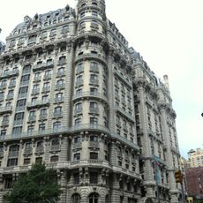
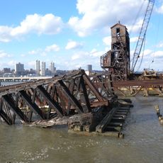
The West Side Elevated Highway was an elevated roadway along Manhattan's western edge, built with steel columns supporting the structure above the Hudson River. The six-lane facility featured industrial-style railings and connected Manhattan's traffic flow from north to south along the waterfront.

Construction began in 1929 to relieve traffic on West Street, which was called Death Avenue due to frequent collisions between trains and vehicles. The elevated roadway was meant to separate vehicular traffic from the dangerous ground-level crossing.

Photographer Jan Staller captured the abandoned structure through long-exposure photographs in the late 1970s, documenting its final years. His images show how the deteriorating roadway became a subject of artistic interest during its decline.

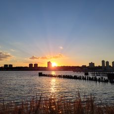
Visitors can explore remnants of the original site today, though only scattered structural pieces remain after its demolition through 1989. The waterfront area where it once stood is best explored on foot from the street level.

Despite its length, the roadway became functionally obsolete soon after completion in 1951 because tight exit ramps could not accommodate large trucks. In 1973, a single truck carrying asphalt broke through a concrete span, hastening the structure's final closure.

The community of curious travelers

AroundUs brings together thousands of curated places, local tips, and hidden gems, enriched daily by 60,000 contributors worldwide.

Start exploring
GPS coordinates
40.78130,-73.98783
Latest update
December 20, 2025 11:24
Reviews
Share your experience

No review yet

Discussions
Start a discussion...

No discussion yet

« West Side Elevated Highway - Former elevated highway in Manhattan, United States » is provided by Around Us (aroundus.com). Images and texts are derived from Wikimedia project under a Creative Commons license. You are allowed to copy, distribute, and modify copies of this page, under the conditions set by the license, as long as this note is clearly visible.

Discover hidden gems everywhere you go!

From secret cafés to breathtaking viewpoints, skip the crowded tourist spots and find places that match your style. Our app makes it easy with voice search, smart filtering, route optimization, and insider tips from travelers worldwide. Download now for the complete mobile experience.

Around Us App Screenshot

A unique approach to discovering new places

Le Figaro

All the places worth exploring

France Info

A tailor-made excursion in just a few clicks

20 Minutes

Around Us
Travel Guide & Maps
Download

Send to your phone

QR Code
1

Open the camera app on your mobile.

2

Point at the QR code with your camera. A notification will appear.

3

Tap the notification to open the link.