Chest opened
+${chestReward.xp} XP
Explorer
NOUVEAU ×${chestReward.collectible.quantity}
tapez pour fermer
Chest locked

Open chests in the app

Around Us is built for your phone — chests unlock when you walk, explore and capture nearby places.

Enable Location

We need your location to show you interesting places around you

Discover nearby places

Find interesting locations and hidden gems around you

Precise directions

Get accurate directions and distances to places

Your location is never shared with other users. It's only used when you tap the location button.

Whitestone Cliffs Trail

Log in to your account

Start exploring — it's free

Trusted by 72,882 travelers worldwide

Continue with Google
Continue with Apple
or

We will send you a code to connect

By continuing, you accept our Terms and Conditions and our Privacy Policy

Check your inbox

We've sent a pincode in your inbox. Please enter the code below.

Whitestone Cliffs Trail
Discussion Reviews 1 Photos
2k Popularity

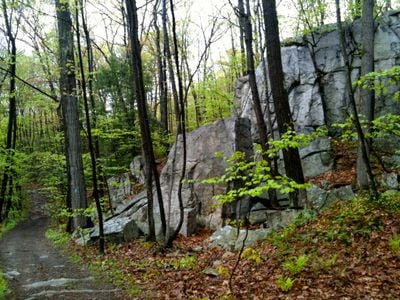
Whitestone Cliffs Trail, Weg in den Vereinigten Staaten

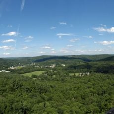
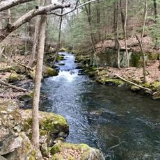
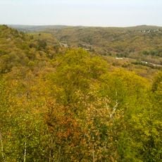
Whitestone Cliffs Trail is a short loop path near Plymouth, Connecticut that winds through about 2.5 kilometers of rocky woodland with streams and small waterfalls. The route passes white stone cliffs, crosses a small bridge, includes rocky scrambles, and reaches overlooks where views extend across wooded valleys.

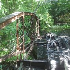
In the 1840s, a quarry near the cliffs supplied stone for railroad construction along the Naugatuck River. A railroad spur was built to carry stones from the quarry to the tracks below, and remnants of this activity remain visible in the woods.

The trail's name references the white stone cliffs visible from the river and nearby roads, which have long served as local landmarks. These rock formations remain part of how people recognize and connect with this forested area today.

A small parking area off Mount Tobe Road provides easy access to the trailhead. The path can be wet and slippery near streams and boggy areas, so sturdy shoes and careful footing are important, especially after rain or during wet seasons.

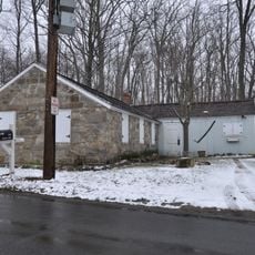
An archery range operated in the area during the late twentieth century, and visitors can still find remnants of old range markers and a wooden pavilion in the woods. These unexpected relics offer a glimpse into how the forest has been used for different purposes over time.

The community of curious travelers

AroundUs brings together thousands of curated places, local tips, and hidden gems, enriched daily by 60,000 contributors worldwide.

Start exploring
Location
GPS coordinates
41.61560,-73.05810
Latest update
February 9, 2026 08:21
Around this place
Holy Land USA
United States of America

Holy Land USA

8 km
Black Rock State Park
United States of America

Black Rock State Park

6 km
Jericho Trail
United States of America

Jericho Trail

1.5 km
Mattatuck Museum
United States of America

Mattatuck Museum

6.6 km
Waterbury Municipal Center Complex
United States of America

Waterbury Municipal Center Complex

6.9 km
Hancock Brook Trail
United States of America

Hancock Brook Trail

1.4 km
Mattatuck State Forest
United States of America

Mattatuck State Forest

4.2 km
Thomaston Opera House
United States of America

Thomaston Opera House

6.6 km
United States of America

Lock Museum of America

8 km
Bank Street Historic District
United States of America

Bank Street Historic District

7.1 km
Benedict-Miller House
United States of America

Benedict-Miller House

6.2 km
Beth El Synagogue
United States of America

Beth El Synagogue

5.5 km
Trinity Church
United States of America

Trinity Church

6.5 km
Reynolds Bridge
United States of America

Reynolds Bridge

4.5 km
Statue of Christopher Columbus
United States of America

Statue of Christopher Columbus

6.9 km
John Kendrick House
United States of America

John Kendrick House

6.8 km
George S. Abbott Building
United States of America

George S. Abbott Building

6.5 km
Southwest District School
United States of America

Southwest District School

7.2 km
Sheffield Street Bridge
United States of America

Sheffield Street Bridge

2.2 km
Enoch Hibbard House and George Granniss House
United States of America

Enoch Hibbard House and George Granniss House

6.8 km
Overlook Historic District
United States of America

Overlook Historic District

5.4 km
Roderick Bryan House
United States of America

Roderick Bryan House

7.1 km
Terryville Waterwheel
United States of America

Terryville Waterwheel

8 km
Matthews and Willard Factory
United States of America

Matthews and Willard Factory

6.8 km
Wolcott Green Historic District
United States of America

Wolcott Green Historic District

7 km
Watertown Center Historic District
United States of America

Watertown Center Historic District

5.3 km
Train Station
United States of America

Train Station

6.5 km
American Italian Civic Club Park
United States of America

American Italian Civic Club Park

3.2 km
Show the full map
Reviews
Share your experience

No review yet

Discussions
Start a discussion...

No discussion yet

« Whitestone Cliffs Trail - Weg in den Vereinigten Staaten » is provided by Around Us (aroundus.com). Images and texts are derived from Wikimedia project under a Creative Commons license. You are allowed to copy, distribute, and modify copies of this page, under the conditions set by the license, as long as this note is clearly visible.

Discover hidden gems everywhere you go!

From secret cafés to breathtaking viewpoints, skip the crowded tourist spots and find places that match your style. Our app makes it easy with voice search, smart filtering, route optimization, and insider tips from travelers worldwide. Download now for the complete mobile experience.

Around Us App Screenshot

A unique approach to discovering new places

Le Figaro

All the places worth exploring

France Info

A tailor-made excursion in just a few clicks

20 Minutes

Around Us
Travel Guide & Maps
Download

Send to your phone

QR Code
1

Open the camera app on your mobile.

2

Point at the QR code with your camera. A notification will appear.

3

Tap the notification to open the link.