Enable Location

We need your location to show you interesting places around you

Discover nearby places

Find interesting locations and hidden gems around you

Precise directions

Get accurate directions and distances to places

Your location is never shared with other users. It's only used when you tap the location button.

William H. Putnam Memorial Bridge

Log in to your account

Start exploring — it's free

Trusted by 62,533 travelers worldwide

Continue with Google
Continue with Apple
or

We will send you a code to connect

By continuing, you accept our Terms and Conditions and our Privacy Policy

Check your inbox

We've sent a pincode in your inbox. Please enter the code below.

William H. Putnam Memorial Bridge

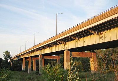
William H. Putnam Memorial Bridge, Steel girder road bridge over Connecticut River between Wethersfield and Glastonbury, United States

The William H. Putnam Memorial Bridge is a steel girder structure that carries Route 3 traffic across the Connecticut River on four lanes. It spans between Wethersfield and Glastonbury, providing clearance of about 80 feet (24 m) for river vessels passing underneath.

The bridge opened in the late 1950s as part of Route 3 freeway development, initially linking Interstate 91 in Wethersfield with Main Street in Glastonbury. It became a key connection for growing traffic across the Hartford region.

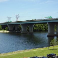
The bridge serves as an essential transportation link in the Hartford area, connecting communities on both sides of the Connecticut River for daily commuters and travelers.

The bridge gets crowded during rush hours, particularly in early morning and late afternoon when commuters travel through the Hartford area. A pedestrian walkway allows safe crossing on foot.

In the early 1970s, plans existed to transform the structure into a double-decker design for Interstate 491, but the project was canceled in 1973. That ambitious expansion would have fundamentally changed the crossing and increased capacity significantly.

The community of curious travelers

AroundUs brings together thousands of curated places, local tips, and hidden gems, enriched daily by 60,000 contributors worldwide.

Start exploring
Location
GPS coordinates
41.71420,-72.64080
Latest update
December 14, 2025 12:24
Around this place
Trinity Health Stadium
United States of America

Trinity Health Stadium

4.7 km
Colt Armory
United States of America

Colt Armory

5.1 km
Armsmear
United States of America

Armsmear

5.2 km
Coltsville Historic District
United States of America

Coltsville Historic District

5.2 km
Charter Oak Bridge
United States of America

Charter Oak Bridge

4.5 km
Colt Park
United States of America

Colt Park

4.9 km
United States of America

Morgan G. Bulkeley Stadium

3.6 km
Silas Deane House
United States of America

Silas Deane House

2.4 km
Buttolph-Williams House
United States of America

Buttolph-Williams House

929 m
J. B. Williams Co. Historic District
United States of America

J. B. Williams Co. Historic District

3.9 km
Gen. Martin Kellogg House
United States of America

Gen. Martin Kellogg House

4.5 km
Roger Butler House
United States of America

Roger Butler House

3.2 km
Washington Street School
United States of America

Washington Street School

5.2 km
Gideon Welles House
United States of America

Gideon Welles House

2.7 km
John Robbins House
United States of America

John Robbins House

4 km
South Green Historic District
United States of America

South Green Historic District

5.1 km
Selden Brewer House
United States of America

Selden Brewer House

2.5 km
Glastonbury Historic District
United States of America

Glastonbury Historic District

2.9 km
Parkside Historic District
United States of America

Parkside Historic District

4.9 km
Fairfield Avenue Historic District
United States of America

Fairfield Avenue Historic District

4.9 km
James B. Colt House
United States of America

James B. Colt House

5 km
Curtisville Historic District
United States of America

Curtisville Historic District

2 km
Grandview Terrace Boulevard
United States of America

Grandview Terrace Boulevard

4.7 km
Naubuc Avenue-Broad Street Historic District
United States of America

Naubuc Avenue-Broad Street Historic District

2.1 km
Pratt & Whitney Hangar Museum
United States of America

Pratt & Whitney Hangar Museum

4.8 km
Webb-Deane-Stevens Museum
United States of America

Webb-Deane-Stevens Museum

1.1 km
Joseph Webb House
United States of America

Joseph Webb House

1.1 km
Kimberly Mansion
United States of America

Kimberly Mansion

3.9 km
Show the full map
« William H. Putnam Memorial Bridge - Steel girder road bridge over Connecticut River between Wethersfield and Glastonbury, United States » is provided by Around Us (aroundus.com). Images and texts are derived from Wikimedia project under a Creative Commons license. You are allowed to copy, distribute, and modify copies of this page, under the conditions set by the license, as long as this note is clearly visible.

Discover hidden gems everywhere you go!

From secret cafés to breathtaking viewpoints, skip the crowded tourist spots and find places that match your style. Our app makes it easy with voice search, smart filtering, route optimization, and insider tips from travelers worldwide. Download now for the complete mobile experience.

Around Us App Screenshot

A unique approach to discovering new places

Le Figaro

All the places worth exploring

France Info

A tailor-made excursion in just a few clicks

20 Minutes

Around Us
Travel Guide & Maps
Download

Send to your phone

QR Code
1

Open the camera app on your mobile.

2

Point at the QR code with your camera. A notification will appear.

3

Tap the notification to open the link.