Chest opened
+${chestReward.xp} XP
Explorer
NOUVEAU ×${chestReward.collectible.quantity}
tapez pour fermer
Chest locked

Open chests in the app

Around Us is built for your phone — chests unlock when you walk, explore and capture nearby places.

Enable Location

We need your location to show you interesting places around you

Discover nearby places

Find interesting locations and hidden gems around you

Precise directions

Get accurate directions and distances to places

Your location is never shared with other users. It's only used when you tap the location button.

Zoar Valley

Log in to your account

Start exploring — it's free

Trusted by 72,880 travelers worldwide

Continue with Google
Continue with Apple
or

We will send you a code to connect

By continuing, you accept our Terms and Conditions and our Privacy Policy

Check your inbox

We've sent a pincode in your inbox. Please enter the code below.

Zoar Valley
Discussion Reviews 1 Photos
10.4k Popularity

Zoar Valley, Multiple Use Area in Gowanda, United States

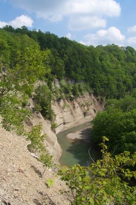
Zoar Valley is a large natural area in western New York with deep gorges carved along Cattaraugus Creek. Steep rock walls rise 100 to 500 feet above the water, creating a dramatic canyon landscape that stretches for miles.

Land protection efforts began in the early 1960s when private donors contributed property to preserve the valley's natural features. The state gradually established formal management and public access to the gorge area.

The name comes from a biblical place, chosen by an early settler who saw spiritual meaning in the landscape. Today visitors come to experience the natural gorge and water features that shaped this valley.

The main parking and access point is at Forty Road, where trails lead down to the creek for hiking and fishing. A wheelchair-accessible viewing platform allows visitors to see the gorge without needing to walk the trails.

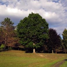
The forest floor contains rare old-growth stands of eastern hemlock and tulip trees that grow to exceptional sizes. This type of mature forest ecosystem is increasingly difficult to find in the northeastern United States.

The community of curious travelers

AroundUs brings together thousands of curated places, local tips, and hidden gems, enriched daily by 60,000 contributors worldwide.

Start exploring
Location
GPS coordinates
42.43970,-78.87330
Latest update
December 10, 2025 15:54
Around this place
Eternal Flame Falls
United States of America

Eternal Flame Falls

30.8 km
Graycliff
United States of America

Graycliff

31.5 km
Gowanda Correctional Facility
United States of America

Gowanda Correctional Facility

7.5 km
Chestnut Ridge Park
United States of America

Chestnut Ridge Park

31.8 km
Thomas Indian School
United States of America

Thomas Indian School

15 km
Griffis Sculpture Park
United States of America

Griffis Sculpture Park

16.8 km
Evangola State Park
United States of America

Evangola State Park

26.4 km
Erie Federal Courthouse
United States of America

Erie Federal Courthouse

23.6 km
Springville Center for the Arts
United States of America

Springville Center for the Arts

18.6 km
Gladden Windmill
United States of America

Gladden Windmill

22.8 km
Nannen Arboretum
United States of America

Nannen Arboretum

24.1 km
First Church of Evans Complex
United States of America

First Church of Evans Complex

29.5 km
Bank of Gowanda
United States of America

Bank of Gowanda

5.8 km
Leon United Methodist Church
United States of America

Leon United Methodist Church

20.2 km
First Congregational Church of Otto
United States of America

First Congregational Church of Otto

10.1 km
Citizens National Bank
United States of America

Citizens National Bank

18.5 km
Ellicottville Town Hall
United States of America

Ellicottville Town Hall

24.6 km
Gamel Hexadecagon Barn
United States of America

Gamel Hexadecagon Barn

16 km
Griffins Mills Presbyterian Church
United States of America

Griffins Mills Presbyterian Church

36 km
Cattaraugus Village Commercial Historic District
United States of America

Cattaraugus Village Commercial Historic District

12.3 km
Hamburg Downtown Historic District
United States of America

Hamburg Downtown Historic District

30.9 km
University Presbyterian Church
United States of America

University Presbyterian Church

35.3 km
Gowanda Village Historic District
United States of America

Gowanda Village Historic District

5.8 km
East Otto Union School
United States of America

East Otto Union School

11.2 km
Rider-Hopkins Farm and Olmsted Camp
United States of America

Rider-Hopkins Farm and Olmsted Camp

31.4 km
East Hill Historic District
United States of America

East Hill Historic District

19.2 km
Ellicottville Historic District
United States of America

Ellicottville Historic District

24.6 km
East Main-Mechanic Streets Historic District
United States of America

East Main-Mechanic Streets Historic District

18.6 km
Show the full map
Reviews
Share your experience

No review yet

Discussions
Start a discussion...

No discussion yet

« Zoar Valley - Multiple Use Area in Gowanda, United States » is provided by Around Us (aroundus.com). Images and texts are derived from Wikimedia project under a Creative Commons license. You are allowed to copy, distribute, and modify copies of this page, under the conditions set by the license, as long as this note is clearly visible.

Discover hidden gems everywhere you go!

From secret cafés to breathtaking viewpoints, skip the crowded tourist spots and find places that match your style. Our app makes it easy with voice search, smart filtering, route optimization, and insider tips from travelers worldwide. Download now for the complete mobile experience.

Around Us App Screenshot

A unique approach to discovering new places

Le Figaro

All the places worth exploring

France Info

A tailor-made excursion in just a few clicks

20 Minutes

Around Us
Travel Guide & Maps
Download

Send to your phone

QR Code
1

Open the camera app on your mobile.

2

Point at the QR code with your camera. A notification will appear.

3

Tap the notification to open the link.