Chest opened
+${chestReward.xp} XP
Explorer
NOUVEAU ×${chestReward.collectible.quantity}
tapez pour fermer
Chest locked

Open chests in the app

Around Us is built for your phone — chests unlock when you walk, explore and capture nearby places.

Enable Location

We need your location to show you interesting places around you

Discover nearby places

Find interesting locations and hidden gems around you

Precise directions

Get accurate directions and distances to places

Your location is never shared with other users. It's only used when you tap the location button.

Spectacle Island

Log in to your account

Start exploring — it's free

Trusted by 72,998 travelers worldwide

Continue with Google
Continue with Apple
or

We will send you a code to connect

By continuing, you accept our Terms and Conditions and our Privacy Policy

Check your inbox

We've sent a pincode in your inbox. Please enter the code below.

Spectacle Island
Discussion Reviews 1 Photos
27.4k Popularity

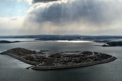
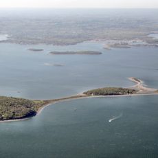
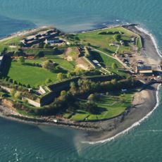
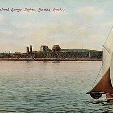
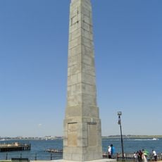
Spectacle Island, Public park island in Boston Harbor, US

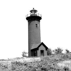
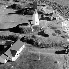
Spectacle Island is a public park on a harbor island near Boston with expansive grounds spanning about 114 acres and several miles of walking routes. Visitors can reach the highest point of the island, which rises about 157 feet above the water level and offers views across the harbor.

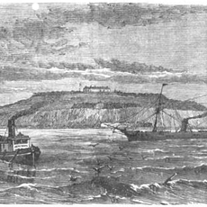
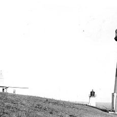
The island began as a quarantine facility in 1717, serving to isolate the sick during disease outbreaks. It later became a resort destination, then an industrial area, and finally a dumping ground until cleaning efforts began in the late 20th century.

Native Americans came here seasonally to gather food from the waters and shore. Their presence left traces that archaeologists have uncovered, revealing stories of life on the water long before the city grew around it.

Getting there is easiest by ferry from downtown Boston, with regular service throughout the day during the season. Once on the island, you'll find restrooms, an information center, and a staffed beach where swimming is possible in warmer months.

For decades the site was a landfill dumping ground, until it was restored using soil excavated from Boston's underground highway project. This environmental cleanup turned what was once a contaminated site into the recreational space you see today.

The community of curious travelers

AroundUs brings together thousands of curated places, local tips, and hidden gems, enriched daily by 60,000 contributors worldwide.

Start exploring
Location
GPS coordinates
42.32533,-70.98704
Latest update
December 20, 2025 13:47
Around this place
John F. Kennedy Presidential Library and Museum
United States of America

John F. Kennedy Presidential Library and Museum

4 km
Institute of Contemporary Art, Boston
United States of America

Institute of Contemporary Art, Boston

5.5 km
Peddocks Island
United States of America

Peddocks Island

5.4 km
Leader Bank Pavilion
United States of America

Leader Bank Pavilion

4.9 km
Fort Warren
United States of America

Fort Warren

4.9 km
Fort Strong
United States of America

Fort Strong

2.6 km
Fort Andrews
United States of America

Fort Andrews

5.3 km
Long Island Viaduct
United States of America

Long Island Viaduct

1.9 km
Squantum Point Park
United States of America

Squantum Point Park

4.7 km
The Partisans
United States of America

The Partisans

5.2 km
Fort Standish
United States of America

Fort Standish

4.9 km
Calf Pasture Pumping Station Complex
United States of America

Calf Pasture Pumping Station Complex

4.1 km
Fort Winthrop
United States of America

Fort Winthrop

3.6 km
Long Island Head Light
United States of America

Long Island Head Light

2.5 km
Statue of David Farragut
United States of America

Statue of David Farragut

3.3 km
Monan Park
United States of America

Monan Park

4.7 km
Deer Island Light
United States of America

Deer Island Light

3.1 km
Fort Andrew
United States of America

Fort Andrew

5.4 km
Cathedral of St. George Historic District
United States of America

Cathedral of St. George Historic District

4.8 km
Fort Independence
United States of America

Fort Independence

2.5 km
Winthrop Shore Drive
United States of America

Winthrop Shore Drive

5.3 km
Spectacle Island Range Lights
United States of America

Spectacle Island Range Lights

335 m
Harrison Loring House
United States of America

Harrison Loring House

4 km
Broad Sound Channel Inner Range Lights
United States of America

Broad Sound Channel Inner Range Lights

281 m
John R. Nelson House
United States of America

John R. Nelson House

3.5 km
United States of America

Old Harbor Reservation Parkways

4.9 km
Clipper Ship Monument to Donald McKay
United States of America

Clipper Ship Monument to Donald McKay

2.5 km
Massachusetts Archives & Commonwealth Museum
United States of America

Massachusetts Archives & Commonwealth Museum

4.1 km
Show the full map
Reviews
Share your experience

No review yet

Discussions
Start a discussion...

No discussion yet

« Spectacle Island - Public park island in Boston Harbor, US » is provided by Around Us (aroundus.com). Images and texts are derived from Wikimedia project under a Creative Commons license. You are allowed to copy, distribute, and modify copies of this page, under the conditions set by the license, as long as this note is clearly visible.

Discover hidden gems everywhere you go!

From secret cafés to breathtaking viewpoints, skip the crowded tourist spots and find places that match your style. Our app makes it easy with voice search, smart filtering, route optimization, and insider tips from travelers worldwide. Download now for the complete mobile experience.

Around Us App Screenshot

A unique approach to discovering new places

Le Figaro

All the places worth exploring

France Info

A tailor-made excursion in just a few clicks

20 Minutes

Around Us
Travel Guide & Maps
Download

Send to your phone

QR Code
1

Open the camera app on your mobile.

2

Point at the QR code with your camera. A notification will appear.

3

Tap the notification to open the link.