Enable Location

We need your location to show you interesting places around you

Discover nearby places

Find interesting locations and hidden gems around you

Precise directions

Get accurate directions and distances to places

Your location is never shared with other users. It's only used when you tap the location button.

Winthrop Shore Drive

Log in to your account

Start exploring — it's free

Trusted by 62,942 travelers worldwide

Continue with Google
Continue with Apple
or

We will send you a code to connect

By continuing, you accept our Terms and Conditions and our Privacy Policy

Check your inbox

We've sent a pincode in your inbox. Please enter the code below.

Discussion Reviews 1 Photos
1.3k Popularity

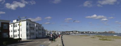
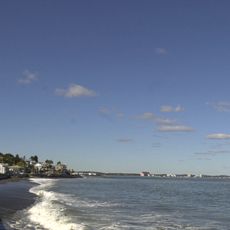
Winthrop Shore Drive, Oceanfront parkway in Winthrop, Massachusetts, US.

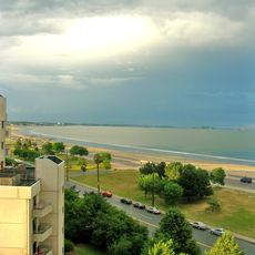
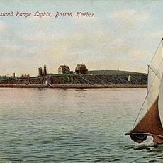
Winthrop Shore Drive is a mile-long parkway that runs along the Atlantic Ocean with a wide promenade suitable for walking and cycling. The landscaped grounds provide direct access to the shore and allow visitors to experience coastal views at a leisurely pace.

The parkway was designed by landscape architect Charles Eliot in the 1890s and completed in 1900 as part of a regional park system. It represented an early effort to create public waterfront access for the Boston metropolitan area.

The parkway functions as part of the Metropolitan Park System of Greater Boston, connecting multiple public recreational spaces in the region.

The parkway is accessible via the MBTA Blue Line to Orient Heights station, with bus connections nearby. Wear appropriate footwear for walking on paved surfaces, especially during wet weather.

The site was listed on the National Register of Historic Places in 2004 for its early 20th-century landscape design, a detail many visitors overlook. This designation recognizes how the parkway was carefully planned to balance natural features with public use.

The community of curious travelers

AroundUs brings together thousands of curated places, local tips, and hidden gems, enriched daily by 60,000 contributors worldwide.

Start exploring
Location
GPS coordinates
42.37056,-70.96806
Latest update
December 14, 2025 17:40
Around this place
Revere Beach
United States of America

Revere Beach

4.6 km
Fort Strong
United States of America

Fort Strong

4.6 km
Belle Isle Marsh Reservation
United States of America

Belle Isle Marsh Reservation

2.8 km
Fort Heath
United States of America

Fort Heath

2.1 km
Chelsea Street Bridge
United States of America

Chelsea Street Bridge

4.8 km
Deane Winthrop House
United States of America

Deane Winthrop House

1.6 km
Fort Winthrop
United States of America

Fort Winthrop

4.2 km
Long Island Head Light
United States of America

Long Island Head Light

4.6 km
Deer Island Light
United States of America

Deer Island Light

3.6 km
Rumney Marsh Burying Ground
United States of America

Rumney Marsh Burying Ground

5.2 km
Temple Ohabei Shalom Cemetery
United States of America

Temple Ohabei Shalom Cemetery

4.1 km
Mary Ellen Welch Greenway
United States of America

Mary Ellen Welch Greenway

5.1 km
Fort Independence
United States of America

Fort Independence

5.1 km
Christina and John Markey Memorial Pedestrian Bridge
United States of America

Christina and John Markey Memorial Pedestrian Bridge

5.1 km
Winthrop Parkway
United States of America

Winthrop Parkway

2.6 km
Church of Christ
United States of America

Church of Christ

5.3 km
Spectacle Island Range Lights
United States of America

Spectacle Island Range Lights

5 km
Baker Congregational Church
United States of America

Baker Congregational Church

4.3 km
Bennington Street Burying Ground
United States of America

Bennington Street Burying Ground

4.5 km
Immaculate Conception Rectory
United States of America

Immaculate Conception Rectory

5.4 km
Broad Sound Channel Inner Range Lights
United States of America

Broad Sound Channel Inner Range Lights

5 km
Highland School
United States of America

Highland School

1.7 km
James O. Conway Memorial
United States of America

James O. Conway Memorial

3.1 km
Edward B. Newton School
United States of America

Edward B. Newton School

1.7 km
Winthrop Center/Metcalf Square Historic District
United States of America

Winthrop Center/Metcalf Square Historic District

1.5 km
Clipper Ship Monument to Donald McKay
United States of America

Clipper Ship Monument to Donald McKay

4.9 km
Lovells Island Range Lights
United States of America

Lovells Island Range Lights

5.2 km
Nix's Mate Daybeacon
United States of America

Nix's Mate Daybeacon

4.8 km
Show the full map
Reviews
Share your experience

No review yet

Discussions
Start a discussion...

No discussion yet

« Winthrop Shore Drive - Oceanfront parkway in Winthrop, Massachusetts, US » is provided by Around Us (aroundus.com). Images and texts are derived from Wikimedia project under a Creative Commons license. You are allowed to copy, distribute, and modify copies of this page, under the conditions set by the license, as long as this note is clearly visible.

Discover hidden gems everywhere you go!

From secret cafés to breathtaking viewpoints, skip the crowded tourist spots and find places that match your style. Our app makes it easy with voice search, smart filtering, route optimization, and insider tips from travelers worldwide. Download now for the complete mobile experience.

Around Us App Screenshot

A unique approach to discovering new places

Le Figaro

All the places worth exploring

France Info

A tailor-made excursion in just a few clicks

20 Minutes

Around Us
Travel Guide & Maps
Download

Send to your phone

QR Code
1

Open the camera app on your mobile.

2

Point at the QR code with your camera. A notification will appear.

3

Tap the notification to open the link.