Temple Ohabei Shalom Cemetery

Log in to your account

AroundUs is a community-driven map of interesting places, built by curious explorers like you. It grows with every review, story, and photo you share.
Connect to save your favorite spots, contribute locations, and create personalized routes.
Continue with Google
Continue with Apple
Continue with X
Continue with Facebook
Continue with email
By continuing, you accept our Terms and Conditions and our Privacy Policy
Create an account
Add to collection
Map
Suggest a change
Share

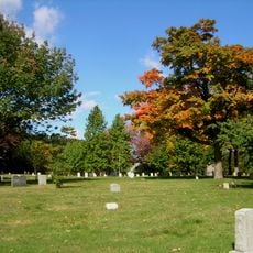
Temple Ohabei Shalom Cemetery, Historic Jewish cemetery in East Boston, United States.

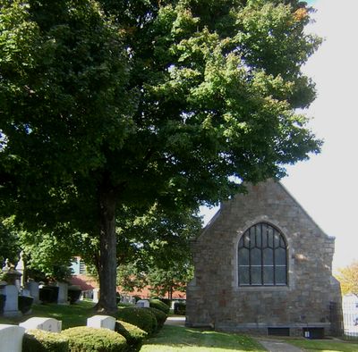
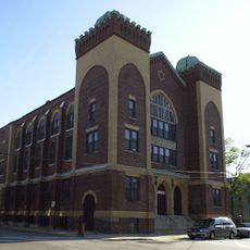
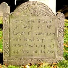
The cemetery sits on Wordsworth Street in East Boston and serves as a burial ground for Jewish residents since 1844. Gravestones bear Hebrew and English inscriptions across the roughly 2.4 acre site, with a Gothic Revival chapel built in 1903 marking its grounds.

The cemetery became the first legally recognized Jewish burial ground in Massachusetts in 1844, after Boston's first synagogue received permission from city officials. This establishment marked a turning point for the Jewish community, which had previously transported its deceased to other locations.

The chapel in Gothic Revival style shows how the Jewish community blended its religious traditions with American architecture of the 1800s. On the gravestones, visitors see Hebrew and English inscriptions that record the presence and integration of Jewish residents into Boston's life.

Visitors can use maintained GPS coordinates and photographs to locate graves and find about 86 percent of burial sites documented in accessible records. These tools help you navigate the grounds independently and find the names and locations you are looking for without getting lost.

Before this cemetery opened, Jewish families had to transport their deceased to burial grounds in Rhode Island, the Caribbean, or Europe, a difficult practice that lasted generations. Once this ground became available, it relieved the community of this heavy burden and became a place of local importance.

Location: Boston

Architectural style: Gothic Revival

GPS coordinates: 42.38250,-71.01458

Latest update: December 14, 2025 12:25

Photos
Around this place
Tobin Bridge
United States of America

Tobin Bridge

2.7 km
United States lightship Nantucket
United States of America

United States lightship Nantucket

2.9 km
Belle Isle Marsh Reservation
United States of America

Belle Isle Marsh Reservation

2.1 km
Chelsea Street Bridge
United States of America

Chelsea Street Bridge

790 m
Deane Winthrop House
United States of America

Deane Winthrop House

3 km
Eagle Hill Historic District
United States of America

Eagle Hill Historic District

1.7 km
Our Lady of Mount Carmel Church
United States of America

Our Lady of Mount Carmel Church

2.1 km
Congregation Agudath Shalom
United States of America

Congregation Agudath Shalom

2.2 km
Andrew P. McArdle Memorial Bridge
United States of America

Andrew P. McArdle Memorial Bridge

2.1 km
Rumney Marsh Burying Ground
United States of America

Rumney Marsh Burying Ground

2.9 km
Donald McKay House
United States of America

Donald McKay House

1.8 km
Mary Ellen Welch Greenway
United States of America

Mary Ellen Welch Greenway

1.5 km
Bellingham Square Historic District
United States of America

Bellingham Square Historic District

1.9 km
Trinity Neighborhood House
United States of America

Trinity Neighborhood House

2.1 km
C. Henry Kimball House
United States of America

C. Henry Kimball House

2.8 km
Winthrop Parkway
United States of America

Winthrop Parkway

2.9 km
Naval Hospital Boston Historic District
United States of America

Naval Hospital Boston Historic District

2.7 km
Church of Christ
United States of America

Church of Christ

3 km
Baker Congregational Church
United States of America

Baker Congregational Church

257 m
Bennington Street Burying Ground
United States of America

Bennington Street Burying Ground

555 m
Immaculate Conception Rectory
United States of America

Immaculate Conception Rectory

2.7 km
Bellingham-Cary House
United States of America

Bellingham-Cary House

2.1 km
James O. Conway Memorial
United States of America

James O. Conway Memorial

1.1 km
Downtown Chelsea Residential Historic District
United States of America

Downtown Chelsea Residential Historic District

2 km
Edward B. Newton School
United States of America

Edward B. Newton School

2.4 km
Theodore Lyman School
United States of America

Theodore Lyman School

2.2 km
Winthrop Center/Metcalf Square Historic District
United States of America

Winthrop Center/Metcalf Square Historic District

2.6 km
East Boston Branch Library
United States of America

East Boston Branch Library

2.1 km
Show the full map
Reviews

Visited this place? Tap the stars to rate it and share your experience / photos with the community! Try now! You can cancel it anytime.

« Temple Ohabei Shalom Cemetery - Historic Jewish cemetery in East Boston, United States » is provided by Around Us (aroundus.com). Images and texts are derived from Wikimedia project under a Creative Commons license. You are allowed to copy, distribute, and modify copies of this page, under the conditions set by the license, as long as this note is clearly visible.

Discover hidden gems everywhere you go!

From secret cafés to breathtaking viewpoints, skip the crowded tourist spots and find places that match your style. Our app makes it easy with voice search, smart filtering, route optimization, and insider tips from travelers worldwide. Download now for the complete mobile experience.

Around Us App Screenshot

A unique approach to discovering new places

Le Figaro

All the places worth exploring

France Info

A tailor-made excursion in just a few clicks

20 Minutes