Enable Location

We need your location to show you interesting places around you

Discover nearby places

Find interesting locations and hidden gems around you

Precise directions

Get accurate directions and distances to places

Your location is never shared with other users. It's only used when you tap the location button.

Belle Isle Marsh Reservation

Log in to your account

Start exploring — it's free

Trusted by 61,830 travelers worldwide

Continue with Google
Continue with Apple
or

We will send you a code to connect

By continuing, you accept our Terms and Conditions and our Privacy Policy

Check your inbox

We've sent a pincode in your inbox. Please enter the code below.

Belle Isle Marsh Reservation

Belle Isle Marsh Reservation, Nature reserve and state park in East Boston, United States.

Description

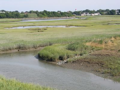
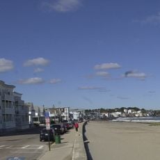
Belle Isle Marsh Reservation is a coastal wetland nature reserve in East Boston covering 350 acres of salt marsh habitat with native plants and diverse wildlife. The property includes marked walking trails, an observation tower, and designated parking areas for visitor access.

History

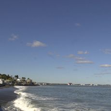
The land was granted to William Brereton in 1628 when it was called Susana Island and later became known as Hog Island before taking its current name. This site was preserved because it represents one of the last remaining salt marshes in the Boston Harbor area.

Culture

The name Belle Isle refers to the island-like shape formed by the surrounding waterways and marsh channels. Visitors can observe how birds nest in the reeds and how local people use the trails to connect with this remaining coastal habitat.

Practical

The reservation is open daily from sunrise to sunset with parking available at Bennington Street. Bring binoculars and wear appropriate clothing for wet and windy conditions, as the site offers bird watching opportunities throughout the year.

Did you know?

The marsh stores carbon in its soil and acts as a natural shield against coastal storms, though few visitors realize this hidden environmental value. This ecosystem service makes the site far more important than its modest appearance suggests.

Location
Inception
1985
GPS coordinates
42.38889,-70.99056
Latest update
December 9, 2025 18:48

AroundUs brings together thousands of curated places, local tips, and hidden gems, enriched daily by 60,000 contributors worldwide. Discover all places nearby (East Boston).

Around this place
Revere Beach
United States of America

Revere Beach

2.1 km
Cyclone
United States of America

Cyclone

3.5 km
Fort Heath
United States of America

Fort Heath

1.7 km
Chelsea Street Bridge
United States of America

Chelsea Street Bridge

2.7 km
Lightning
United States of America

Lightning

3.5 km
Derby Racer
United States of America

Derby Racer

3.5 km
Deane Winthrop House
United States of America

Deane Winthrop House

1.2 km
Eagle Hill Historic District
United States of America

Eagle Hill Historic District

3.7 km
Congregation Agudath Shalom
United States of America

Congregation Agudath Shalom

3.9 km
Rumney Marsh Burying Ground
United States of America

Rumney Marsh Burying Ground

2.4 km
Donald McKay House
United States of America

Donald McKay House

3.9 km
Temple Ohabei Shalom Cemetery
United States of America

Temple Ohabei Shalom Cemetery

2.1 km
Mary Ellen Welch Greenway
United States of America

Mary Ellen Welch Greenway

3.6 km
Bellingham Square Historic District
United States of America

Bellingham Square Historic District

3.5 km
Winthrop Shore Drive
United States of America

Winthrop Shore Drive

2.8 km
Christina and John Markey Memorial Pedestrian Bridge
United States of America

Christina and John Markey Memorial Pedestrian Bridge

2.7 km
Winthrop Parkway
United States of America

Winthrop Parkway

825 m
Church of Christ
United States of America

Church of Christ

2.6 km
Baker Congregational Church
United States of America

Baker Congregational Church

2.3 km
Bennington Street Burying Ground
United States of America

Bennington Street Burying Ground

2.7 km
Immaculate Conception Rectory
United States of America

Immaculate Conception Rectory

2.6 km
Columbus Monument
United States of America

Columbus Monument

3.4 km
Highland School
United States of America

Highland School

1.5 km
Bellingham-Cary House
United States of America

Bellingham-Cary House

3.3 km
James O. Conway Memorial
United States of America

James O. Conway Memorial

1.1 km
Downtown Chelsea Residential Historic District
United States of America

Downtown Chelsea Residential Historic District

3.9 km
Edward B. Newton School
United States of America

Edward B. Newton School

1.4 km
Winthrop Center/Metcalf Square Historic District
United States of America

Winthrop Center/Metcalf Square Historic District

1.4 km
Show the full map
« Belle Isle Marsh Reservation - Nature reserve and state park in East Boston, United States » is provided by Around Us (aroundus.com). Images and texts are derived from Wikimedia project under a Creative Commons license. You are allowed to copy, distribute, and modify copies of this page, under the conditions set by the license, as long as this note is clearly visible.

Discover hidden gems everywhere you go!

From secret cafés to breathtaking viewpoints, skip the crowded tourist spots and find places that match your style. Our app makes it easy with voice search, smart filtering, route optimization, and insider tips from travelers worldwide. Download now for the complete mobile experience.

Around Us App Screenshot

A unique approach to discovering new places

Le Figaro

All the places worth exploring

France Info

A tailor-made excursion in just a few clicks

20 Minutes

Around Us
Travel Guide & Maps
Download

Send to your phone

QR Code
1

Open the camera app on your mobile.

2

Point at the QR code with your camera. A notification will appear.

3

Tap the notification to open the link.