Enable Location

We need your location to show you interesting places around you

Discover nearby places

Find interesting locations and hidden gems around you

Precise directions

Get accurate directions and distances to places

Your location is never shared with other users. It's only used when you tap the location button.

Rumney Marsh Burying Ground

Log in to your account

Start exploring — it's free

Trusted by 62,946 travelers worldwide

Continue with Google
Continue with Apple
or

We will send you a code to connect

By continuing, you accept our Terms and Conditions and our Privacy Policy

Check your inbox

We've sent a pincode in your inbox. Please enter the code below.

Discussion Reviews 1 Photos
2.1k Popularity

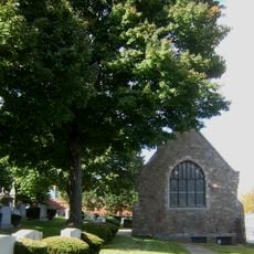
Rumney Marsh Burying Ground, Historic cemetery in Revere, United States.

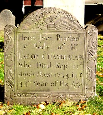
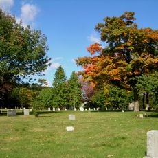
Rumney Marsh Burying Ground is a historic cemetery in Revere that stretches along Butler Street between Elm and Bixby Streets. It holds around 747 memorials, including slate gravestones from various time periods that reflect the growth of the early settlement.

The burial ground was established in 1654 on former Cole Farm land and served as the first cemetery for the communities of Revere, Chelsea, and Winthrop. This location marks the beginning of organized burial practices in this New England region.

The site holds handcrafted gravestones made by Joseph Lamson and remembers families from the early colonial period, including descendants of John Winthrop, governor of Massachusetts Bay Colony. The inscriptions and stonework tell stories of the social conditions and beliefs of people from the 1600s.

The cemetery is accessible during afternoon hours on Tuesday through Thursday, with limited parking near the Butler Street entrance. It is best to check exact hours ahead of time and arrive early to secure a parking spot.

Sixteen documented Black individuals rest in the burial ground, with their names and details preserved on plaques along the Northern wall of the grounds. This memorial honors the often-overlooked presence of Black communities in early New England history.

The community of curious travelers

AroundUs brings together thousands of curated places, local tips, and hidden gems, enriched daily by 60,000 contributors worldwide.

Start exploring
Location
GPS coordinates
42.40778,-71.00583
Latest update
December 14, 2025 09:45
Around this place
Revere Beach
United States of America

Revere Beach

1.2 km
Belle Isle Marsh Reservation
United States of America

Belle Isle Marsh Reservation

2.4 km
Cyclone
United States of America

Cyclone

2.1 km
Fort Heath
United States of America

Fort Heath

3.6 km
Chelsea Street Bridge
United States of America

Chelsea Street Bridge

2.8 km
Lightning
United States of America

Lightning

2.1 km
Derby Racer
United States of America

Derby Racer

2.1 km
Deane Winthrop House
United States of America

Deane Winthrop House

3.6 km
Eagle Hill Historic District
United States of America

Eagle Hill Historic District

3.8 km
Revere Beach Parkway
United States of America

Revere Beach Parkway

3.2 km
Franklin Park
United States of America

Franklin Park

3.7 km
Congregation Agudath Shalom
United States of America

Congregation Agudath Shalom

3.1 km
Andrew P. McArdle Memorial Bridge
United States of America

Andrew P. McArdle Memorial Bridge

3.7 km
Temple Ohabei Shalom Cemetery
United States of America

Temple Ohabei Shalom Cemetery

2.9 km
Bellingham Square Historic District
United States of America

Bellingham Square Historic District

2.8 km
C. Henry Kimball House
United States of America

C. Henry Kimball House

2.5 km
Christina and John Markey Memorial Pedestrian Bridge
United States of America

Christina and John Markey Memorial Pedestrian Bridge

1.4 km
Winthrop Parkway
United States of America

Winthrop Parkway

2.7 km
Church of Christ
United States of America

Church of Christ

154 m
Baker Congregational Church
United States of America

Baker Congregational Church

2.8 km
Bennington Street Burying Ground
United States of America

Bennington Street Burying Ground

3.2 km
Immaculate Conception Rectory
United States of America

Immaculate Conception Rectory

444 m
Columbus Monument
United States of America

Columbus Monument

1.3 km
Highland School
United States of America

Highland School

3.7 km
Bellingham-Cary House
United States of America

Bellingham-Cary House

2.1 km
James O. Conway Memorial
United States of America

James O. Conway Memorial

2.7 km
Downtown Chelsea Residential Historic District
United States of America

Downtown Chelsea Residential Historic District

3.3 km
Edward B. Newton School
United States of America

Edward B. Newton School

3.8 km
Show the full map
Reviews
Share your experience

No review yet

Discussions
Start a discussion...

No discussion yet

« Rumney Marsh Burying Ground - Historic cemetery in Revere, United States » is provided by Around Us (aroundus.com). Images and texts are derived from Wikimedia project under a Creative Commons license. You are allowed to copy, distribute, and modify copies of this page, under the conditions set by the license, as long as this note is clearly visible.

Discover hidden gems everywhere you go!

From secret cafés to breathtaking viewpoints, skip the crowded tourist spots and find places that match your style. Our app makes it easy with voice search, smart filtering, route optimization, and insider tips from travelers worldwide. Download now for the complete mobile experience.

Around Us App Screenshot

A unique approach to discovering new places

Le Figaro

All the places worth exploring

France Info

A tailor-made excursion in just a few clicks

20 Minutes

Around Us
Travel Guide & Maps
Download

Send to your phone

QR Code
1

Open the camera app on your mobile.

2

Point at the QR code with your camera. A notification will appear.

3

Tap the notification to open the link.