Revere Beach Parkway

Log in to your account

AroundUs is a community-driven map of interesting places, built by curious explorers like you. It grows with every review, story, and photo you share.
Connect to save your favorite spots, contribute locations, and create personalized routes.
Continue with Google
Continue with Apple
Continue with X
Continue with Facebook
Continue with email
By continuing, you accept our Terms and Conditions and our Privacy Policy
Create an account
Add to collection
Map
Suggest a change
Share

Revere Beach Parkway, Historic parkway between Medford and Revere, United States.

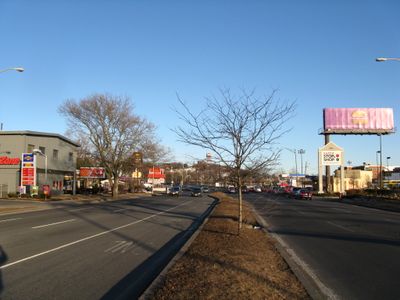
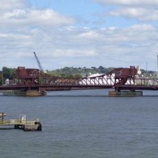
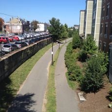
Revere Beach Parkway is a four-mile road that connects Medford with Revere Beach, passing through Everett and Chelsea. The route crosses multiple railroad lines and the Malden River with dedicated bridges built to accommodate this crossing.

Construction began in 1897 following a plan by Charles Eliot to connect inland communities with Revere Beach. It was part of a larger effort to create public green space across the Boston area.

The parkway was built as part of an effort to give working people access to free recreational spaces. Today, visitors can still see this idea reflected in the road's wide, open design that prioritizes movement and green space.

The parkway functions as Route 16 west of Route 1A and Route 145 east of that intersection, connecting the Greater Boston area with major transportation networks. Drivers should note that different sections have different route numbers, which can make navigation slightly confusing at first.

Original construction from 1897 is still visible in several places and was not completely replaced by modern improvements. This makes the parkway an open-air museum of engineering from the turn of the century.

Location: Medford

Location: Everett

Location: Chelsea

Location: Revere

GPS coordinates: 42.40208,-71.04458

Latest update: December 12, 2025 17:45

Photos
Around this place
Bunker Hill Monument
United States of America

Bunker Hill Monument

3.2 km
Boston Navy Yard
United States of America

Boston Navy Yard

3 km
Tobin Bridge
United States of America

Tobin Bridge

1.9 km
Breed's Hill
United States of America

Breed's Hill

3.2 km
Chelsea Street Bridge
United States of America

Chelsea Street Bridge

2.5 km
Eagle Hill Historic District
United States of America

Eagle Hill Historic District

2.5 km
Statue of William Prescott
United States of America

Statue of William Prescott

3.2 km
Congregation Agudath Shalom
United States of America

Congregation Agudath Shalom

1.2 km
Andrew P. McArdle Memorial Bridge
United States of America

Andrew P. McArdle Memorial Bridge

1.9 km
Rumney Marsh Burying Ground
United States of America

Rumney Marsh Burying Ground

3.2 km
Massachusetts Korean War Memorial
United States of America

Massachusetts Korean War Memorial

3.2 km
Bell Rock Memorial Park
United States of America

Bell Rock Memorial Park

2.8 km
Donald McKay House
United States of America

Donald McKay House

2.5 km
Mary Ellen Welch Greenway
United States of America

Mary Ellen Welch Greenway

3.2 km
Bell Rock Cemetery
United States of America

Bell Rock Cemetery

2.8 km
Bellingham Square Historic District
United States of America

Bellingham Square Historic District

1.4 km
Trinity Neighborhood House
United States of America

Trinity Neighborhood House

2.5 km
Monument Square Historic District
United States of America

Monument Square Historic District

3.2 km
C. Henry Kimball House
United States of America

C. Henry Kimball House

788 m
Naval Hospital Boston Historic District
United States of America

Naval Hospital Boston Historic District

1.5 km
Church of Christ
United States of America

Church of Christ

3.2 km
Baker Congregational Church
United States of America

Baker Congregational Church

3 km
Bennington Street Burying Ground
United States of America

Bennington Street Burying Ground

3 km
Immaculate Conception Rectory
United States of America

Immaculate Conception Rectory

2.8 km
Bellingham-Cary House
United States of America

Bellingham-Cary House

1.4 km
Charlestown Heights
United States of America

Charlestown Heights

2.9 km
Downtown Chelsea Residential Historic District
United States of America

Downtown Chelsea Residential Historic District

1.6 km
East Boston Branch Library
United States of America

East Boston Branch Library

2.9 km
Show the full map
Reviews

Visited this place? Tap the stars to rate it and share your experience / photos with the community! Try now! You can cancel it anytime.

« Revere Beach Parkway - Historic parkway between Medford and Revere, United States » is provided by Around Us (aroundus.com). Images and texts are derived from Wikimedia project under a Creative Commons license. You are allowed to copy, distribute, and modify copies of this page, under the conditions set by the license, as long as this note is clearly visible.

Discover hidden gems everywhere you go!

From secret cafés to breathtaking viewpoints, skip the crowded tourist spots and find places that match your style. Our app makes it easy with voice search, smart filtering, route optimization, and insider tips from travelers worldwide. Download now for the complete mobile experience.

Around Us App Screenshot

A unique approach to discovering new places

Le Figaro

All the places worth exploring

France Info

A tailor-made excursion in just a few clicks

20 Minutes