Mon-Fayette Expressway Bridge

Log in to your account

AroundUs is a community-driven map of interesting places, built by curious explorers like you. It grows with every review, story, and photo you share.
Connect to save your favorite spots, contribute locations, and create personalized routes.
By continuing, you accept our Terms and Conditions and our Privacy Policy

Mon-Fayette Expressway Bridge

Add to collection
Map
Suggest a change
Share

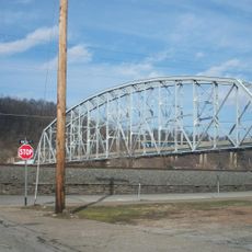
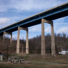
Mon-Fayette Expressway Bridge, Steel bridge in Fayette County, Pennsylvania, US.
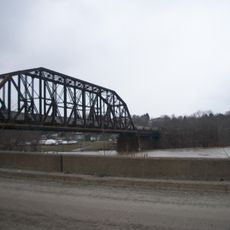
The Mon-Fayette Expressway Bridge spans 3,022 feet across the Monongahela River, connecting Luzerne Township with Centerville through four traffic lanes.

The bridge opened on July 6, 2013, completing the southern section of the expressway and enabling travel from Morgantown, West Virginia to Jefferson Hills, Pennsylvania.

The Pennsylvania Legislature dedicated the bridge to PFC Ronald C Bakewell, a local Vietnam War serviceman who resided near the construction site.

The structure incorporates 51,000 cubic yards of concrete and maintains a 200-foot clearance below, supporting Pennsylvania Route 43 traffic flow.

The bridge construction required an investment of 96 million dollars and contains 1,648 tons of steel to ensure long-term structural integrity.

Location: Pennsylvania

Inception: July 6, 2013

Official opening: July 6, 2013

GPS coordinates: 40.00438,-79.93238

Latest update: March 4, 2025 12:55

Around this place
Show the full map
Bowman's Castle
United States of America

Bowman's Castle

4.6 km
Dunlap's Creek Bridge
United States of America

Dunlap's Creek Bridge

4.2 km
Brownsville Bridge
United States of America

Brownsville Bridge

4.1 km
Penn-Craft Historic District
United States of America

Penn-Craft Historic District

5.3 km
Lane Bane Bridge
United States of America

Lane Bane Bridge

4.6 km
Regester Log House
United States of America

Regester Log House

5.5 km
Oak Hill Estate
United States of America

Oak Hill Estate

4.5 km
Wallace-Baily Tavern
United States of America

Wallace-Baily Tavern

7 km
Old Main
United States of America

Old Main

7.9 km
Brownsville Northside Historic District
United States of America

Brownsville Northside Historic District

4.8 km
Molly Fleming House
United States of America

Molly Fleming House

8 km
California Area Public Library
United States of America

California Area Public Library

8 km
Centerville Historic District
United States of America

Centerville Historic District

5.9 km
W. A. Young and Sons Foundry and Machine Shop
United States of America

W. A. Young and Sons Foundry and Machine Shop

8.3 km
Thomas H. Thompson House
United States of America

Thomas H. Thompson House

3.1 km
Jennings-Gallagher House
United States of America

Jennings-Gallagher House

7.6 km
Joseph Dorsey House
United States of America

Joseph Dorsey House

2 km
Welsh-Emery House
United States of America

Welsh-Emery House

7.7 km
West Brownsville Junction Bridge
United States of America

West Brownsville Junction Bridge

5.8 km
Brownsville Commercial Historic District
United States of America

Brownsville Commercial Historic District

4.3 km
Harrison House
United States of America

Harrison House

4.2 km
Springer Farm
United States of America

Springer Farm

4.5 km
Hugh Laughlin House
United States of America

Hugh Laughlin House

7.8 km
Brown-Moore Blacksmith Shop
United States of America

Brown-Moore Blacksmith Shop

4.5 km
Arboreto de la universidad de California en Pensilvania
United States of America

Arboreto de la universidad de California en Pensilvania

8 km
National Pike Steam Gas and Horse Association
United States of America

National Pike Steam Gas and Horse Association

3.2 km
Hepner–Bailey Field at Adamson Stadium
United States of America

Hepner–Bailey Field at Adamson Stadium

5.7 km
Maxwell Lock & Dam
United States of America

Maxwell Lock & Dam

2.4 km
Show the full map

Reviews

Visited this place? Tap the stars to rate it and share your experience / photos with the community! Try now! You can cancel it anytime.

« Mon-Fayette Expressway Bridge - Steel bridge in Fayette County, Pennsylvania, US. » is provided by Around Us (aroundus.com). Images and texts are derived from Wikimedia project under a Creative Commons license. You are allowed to copy, distribute, and modify copies of this page, under the conditions set by the license, as long as this note is clearly visible.

Discover hidden gems everywhere you go!

From secret cafés to breathtaking viewpoints, skip the crowded tourist spots and find places that match your style. Our app makes it easy with voice search, smart filtering, route optimization, and insider tips from travelers worldwide. Download now for the complete mobile experience.

Around Us App Screenshot

A unique approach to discovering new places

Le Figaro

All the places worth exploring

France Info

A tailor-made excursion in just a few clicks

20 Minutes