·

Enable Location

We need your location to show you interesting places around you

Discover nearby places

Find interesting locations and hidden gems around you

Precise directions

Get accurate directions and distances to places

Your location is never shared with other users. It's only used when you tap the location button.

Kern National Wildlife Refuge

Log in to your account

Start exploring — it's free

Trusted by 62,655 travelers worldwide

Continue with Google
Continue with Apple
or

We will send you a code to connect

By continuing, you accept our Terms and Conditions and our Privacy Policy

Check your inbox

We've sent a pincode in your inbox. Please enter the code below.

Kern National Wildlife Refuge

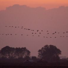
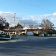
Kern National Wildlife Refuge, National Wildlife Refuge in San Joaquin Valley, California, US.

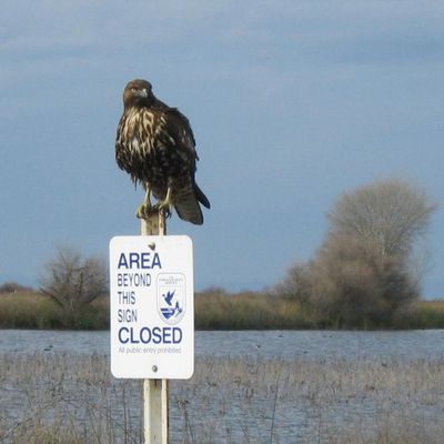
Kern National Wildlife Refuge is a protected area in California's San Joaquin Valley that combines wetlands, dry grasslands, and natural habitats for wildlife. The landscape shifts between open water and vegetation-covered ground, creating diverse spaces for birds and other animals.

This area was once part of Tulare Lake, one of the largest freshwater wetland systems in the American West. Agricultural water management in the mid-1900s reshaped the landscape, which led to the creation of the refuge.

This place serves as a critical stopover for birds traveling between North and South America. You can witness the sheer scale of this migration when thousands of birds arrive and depart during the seasons.

You can drive through the refuge on a looped route with unpaved roads, keeping to a slow pace to see wildlife. Pick clear weather days and visit during daylight hours for the best experience.

The refuge closes to regular visitors during certain months each year to allow exclusive use for hunting activities. This practice helps protect nesting birds and supports sustainable wildlife management.

The community of curious travelers

AroundUs brings together thousands of curated places, local tips, and hidden gems, enriched daily by 60,000 contributors worldwide.

Start exploring
Location
Inception
1960
GPS coordinates
35.74580,-119.61800
Latest update
December 10, 2025 16:25
Around this place
Avenal State Prison
United States of America

Avenal State Prison

52 km
United States of America

Wasco State Prison

25.4 km
North Kern State Prison
United States of America

North Kern State Prison

28.1 km
United States of America

California Substance Abuse Treatment Facility and State Prison, Corcoran

34.8 km
Buck Owens Crystal Palace
United States of America

Buck Owens Crystal Palace

65.7 km
Colonel Allensworth State Historic Park
United States of America

Colonel Allensworth State Historic Park

24.1 km
Buttonwillow Raceway Park
United States of America

Buttonwillow Raceway Park

29.1 km
Zalud House
United States of America

Zalud House

65.3 km
Fox Theater
United States of America

Fox Theater

67.8 km
Bakersfield Sign
United States of America

Bakersfield Sign

65.8 km
Kettleman Hills Hazardous Waste Facility
United States of America

Kettleman Hills Hazardous Waste Facility

42.8 km
Pixley National Wildlife Refuge
United States of America

Pixley National Wildlife Refuge

30 km
Kern County Museum
United States of America

Kern County Museum

66.9 km
The Forty Acres
United States of America

The Forty Acres

30 km
Taoist Temple
United States of America

Taoist Temple

64.8 km
Beale Memorial Clock Tower
United States of America

Beale Memorial Clock Tower

67 km
The Fort
United States of America

The Fort

67.7 km
Hanford Carnegie Museum
United States of America

Hanford Carnegie Museum

64.8 km
Mill Creek
United States of America

Mill Creek

66.8 km
Calloway Canal
United States of America

Calloway Canal

42.8 km
Kings County Courthouse
United States of America

Kings County Courthouse

64.8 km
Jastro Building
United States of America

Jastro Building

67.9 km
Shafter Research Station
United States of America

Shafter Research Station

39 km
Kern County Chamber of Commerce Building
United States of America

Kern County Chamber of Commerce Building

66.9 km
The Pioneer
United States of America

The Pioneer

65.6 km
Alano Club Of Bakersfield
United States of America

Alano Club Of Bakersfield

67.6 km
Fort Preservation Society
United States of America

Fort Preservation Society

67.7 km
Children’s Storybook Garden & Museum
United States of America

Children’s Storybook Garden & Museum

65.1 km
Show the full map
« Kern National Wildlife Refuge - National Wildlife Refuge in San Joaquin Valley, California, US » is provided by Around Us (aroundus.com). Images and texts are derived from Wikimedia project under a Creative Commons license. You are allowed to copy, distribute, and modify copies of this page, under the conditions set by the license, as long as this note is clearly visible.

Discover hidden gems everywhere you go!

From secret cafés to breathtaking viewpoints, skip the crowded tourist spots and find places that match your style. Our app makes it easy with voice search, smart filtering, route optimization, and insider tips from travelers worldwide. Download now for the complete mobile experience.

Around Us App Screenshot

A unique approach to discovering new places

Le Figaro

All the places worth exploring

France Info

A tailor-made excursion in just a few clicks

20 Minutes

Around Us
Travel Guide & Maps
Download

Send to your phone

QR Code
1

Open the camera app on your mobile.

2

Point at the QR code with your camera. A notification will appear.

3

Tap the notification to open the link.