Enable Location

We need your location to show you interesting places around you

Discover nearby places

Find interesting locations and hidden gems around you

Precise directions

Get accurate directions and distances to places

Your location is never shared with other users. It's only used when you tap the location button.

Bakersfield Sign

Log in to your account

Start exploring — it's free

Trusted by 62,871 travelers worldwide

Continue with Google
Continue with Apple
or

We will send you a code to connect

By continuing, you accept our Terms and Conditions and our Privacy Policy

Check your inbox

We've sent a pincode in your inbox. Please enter the code below.

Bakersfield Sign

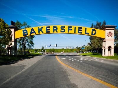
Bakersfield Sign, City landmark over Sillect Avenue in Bakersfield, United States.

The Bakersfield Sign is a yellow arch with blue porcelain lettering that spans Sillect Avenue at its intersection with Buck Owens Boulevard. The structure rises high enough to be visible from State Route 99 and serves as a distinctive gateway marker for the city.

The original structure from 1949 functioned as a footbridge for the Bakersfield Inn and welcomed travelers along the Golden State Highway. A 1999 reconstruction by Sampson Steel used the original blue porcelain letters, maintaining its historical connection to that earlier era.

The sign serves as a visual marker that residents and visitors use to orient themselves in the area and sense arrival in the city. Its presence creates a recognizable moment as people pass through this major intersection.

The sign stands northwest of downtown near the Buck Owens Crystal Palace and provides a readily recognizable reference point for getting oriented. Its location on a well-traveled route makes it easy to reach and offers convenient access to nearby attractions in the area.

The blue porcelain letters come from the original 1949 structure and were carefully reused during the 1999 reconstruction. These salvaged elements create a physical connection between the city's founding era and its modern landscape.

The community of curious travelers

AroundUs brings together thousands of curated places, local tips, and hidden gems, enriched daily by 60,000 contributors worldwide.

Start exploring
Location
GPS coordinates
35.38600,-119.04200
Latest update
December 10, 2025 16:26
Around this place
United States of America

Wasco State Prison

40.5 km
Taft Correctional Institution
United States of America

Taft Correctional Institution

43.8 km
Weedpatch Camp
United States of America

Weedpatch Camp

15.2 km
Buck Owens Crystal Palace
United States of America

Buck Owens Crystal Palace

91 m
Buttonwillow Raceway Park
United States of America

Buttonwillow Raceway Park

47.1 km
Cesar E. Chavez National Monument
United States of America

Cesar E. Chavez National Monument

47.1 km
Fox Theater
United States of America

Fox Theater

2 km
Memorial Stadium
United States of America

Memorial Stadium

7 km
Kern River Canyon
United States of America

Kern River Canyon

48.3 km
Kern County Museum
United States of America

Kern County Museum

2.1 km
The Forty Acres
United States of America

The Forty Acres

47.5 km
Kern County Hall of Records
United States of America

Kern County Hall of Records

2.6 km
Bear Mountain
United States of America

Bear Mountain

41.9 km
Beale Memorial Clock Tower
United States of America

Beale Memorial Clock Tower

2.2 km
Bakersfield City Hall
United States of America

Bakersfield City Hall

2.5 km
Bakersfield Museum of Art
United States of America

Bakersfield Museum of Art

3.2 km
The Fort
United States of America

The Fort

46.5 km
Buena Vista Museum of Natural History
United States of America

Buena Vista Museum of Natural History

2.4 km
Baker Branch Library
United States of America

Baker Branch Library

4.7 km
Tevis Block
United States of America

Tevis Block

2.2 km
Calloway Canal
United States of America

Calloway Canal

23 km
Jastro Building
United States of America

Jastro Building

2.1 km
Shafter Research Station
United States of America

Shafter Research Station

26.8 km
Kern County Chamber of Commerce Building
United States of America

Kern County Chamber of Commerce Building

2.2 km
Kern Veterans Memorial
United States of America

Kern Veterans Memorial

3.4 km
Alano Club Of Bakersfield
United States of America

Alano Club Of Bakersfield

2.7 km
Fort Preservation Society
United States of America

Fort Preservation Society

46.6 km
Beale Memorial Library
United States of America

Beale Memorial Library

3.3 km
Show the full map
« Bakersfield Sign - City landmark over Sillect Avenue in Bakersfield, United States » is provided by Around Us (aroundus.com). Images and texts are derived from Wikimedia project under a Creative Commons license. You are allowed to copy, distribute, and modify copies of this page, under the conditions set by the license, as long as this note is clearly visible.

Discover hidden gems everywhere you go!

From secret cafés to breathtaking viewpoints, skip the crowded tourist spots and find places that match your style. Our app makes it easy with voice search, smart filtering, route optimization, and insider tips from travelers worldwide. Download now for the complete mobile experience.

Around Us App Screenshot

A unique approach to discovering new places

Le Figaro

All the places worth exploring

France Info

A tailor-made excursion in just a few clicks

20 Minutes

Around Us
Travel Guide & Maps
Download

Send to your phone

QR Code
1

Open the camera app on your mobile.

2

Point at the QR code with your camera. A notification will appear.

3

Tap the notification to open the link.