·

Enable Location

We need your location to show you interesting places around you

Discover nearby places

Find interesting locations and hidden gems around you

Precise directions

Get accurate directions and distances to places

Your location is never shared with other users. It's only used when you tap the location button.

Kern River Canyon

Log in to your account

Start exploring — it's free

Trusted by 62,645 travelers worldwide

Continue with Google
Continue with Apple
or

We will send you a code to connect

By continuing, you accept our Terms and Conditions and our Privacy Policy

Check your inbox

We've sent a pincode in your inbox. Please enter the code below.

Kern River Canyon

Kern River Canyon, Natural canyon in Southern Sierra Nevada, California

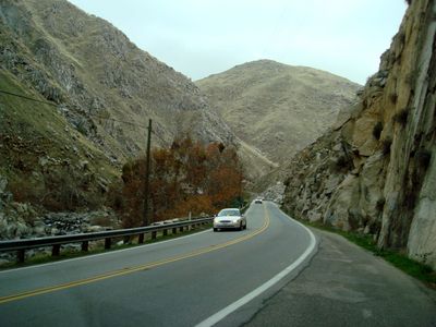
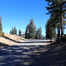
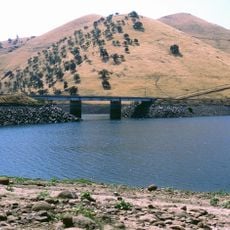
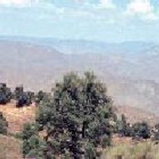
Kern River Canyon is a deep gorge in the southern Sierra Nevada where granite walls rise dramatically and multiple layers of rock are visible. The canyon stretches across a significant distance, with its river flowing through and creating access points for hiking trails and water recreation.

During the mid-19th century, explorer Edward M. Kern mapped this region as part of John C. Fremont's expedition, opening the area to further exploration. Following this documentation, gold mining operations began in the canyon and surrounding areas, transforming local activity for decades.

Native American tribes established settlements along the river banks, using the water and surrounding lands for food gathering and traditional ceremonies.

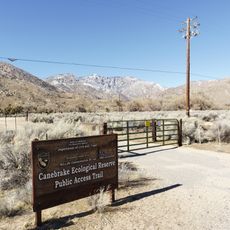
State Route 178 runs through the canyon and provides several access points for hikers and water sports enthusiasts. The best time to visit is autumn and spring when weather is mild and water levels are suitable for safe activities.

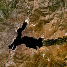
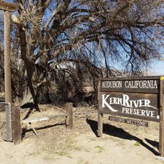
The canyon marks the intersection of five distinct bioregions near Lake Isabella, creating habitats for numerous plant species and the native golden trout.

The community of curious travelers

AroundUs brings together thousands of curated places, local tips, and hidden gems, enriched daily by 60,000 contributors worldwide.

Start exploring
Location
GPS coordinates
35.69580,-118.66800
Latest update
December 8, 2025 21:02
Around this place
Lake Isabella
United States of America

Lake Isabella

21.9 km
Weedpatch Camp
United States of America

Weedpatch Camp

48.4 km
Buck Owens Crystal Palace
United States of America

Buck Owens Crystal Palace

48.4 km
Zalud House
United States of America

Zalud House

52.4 km
Fox Theater
United States of America

Fox Theater

47.8 km
Sherman Pass
United States of America

Sherman Pass

42.7 km
Lake Success
United States of America

Lake Success

46.5 km
Bakersfield Sign
United States of America

Bakersfield Sign

48.3 km
Memorial Stadium
United States of America

Memorial Stadium

42.2 km
Canebrake Ecological Reserve
United States of America

Canebrake Ecological Reserve

44.8 km
Bright Star Wilderness
United States of America

Bright Star Wilderness

43.9 km
United States of America

Long Meadow Grove

32.2 km
Kern County Museum
United States of America

Kern County Museum

46.4 km
Kern County Hall of Records
United States of America

Kern County Hall of Records

47.8 km
Domeland Wilderness
United States of America

Domeland Wilderness

43.8 km
Beale Memorial Clock Tower
United States of America

Beale Memorial Clock Tower

46.3 km
Bakersfield City Hall
United States of America

Bakersfield City Hall

48 km
Bakersfield Museum of Art
United States of America

Bakersfield Museum of Art

47 km
Black Mountain Grove
United States of America

Black Mountain Grove

45.5 km
Buena Vista Museum of Natural History
United States of America

Buena Vista Museum of Natural History

47.5 km
Baker Branch Library
United States of America

Baker Branch Library

45.4 km
Tevis Block
United States of America

Tevis Block

47.8 km
Jastro Building
United States of America

Jastro Building

47.9 km
Kern County Chamber of Commerce Building
United States of America

Kern County Chamber of Commerce Building

46.3 km
Kern Veterans Memorial
United States of America

Kern Veterans Memorial

47.3 km
Alano Club Of Bakersfield
United States of America

Alano Club Of Bakersfield

46.2 km
Kern River Preserve
United States of America

Kern River Preserve

32 km
Beale Memorial Library
United States of America

Beale Memorial Library

47.5 km
Show the full map
« Kern River Canyon - Natural canyon in Southern Sierra Nevada, California » is provided by Around Us (aroundus.com). Images and texts are derived from Wikimedia project under a Creative Commons license. You are allowed to copy, distribute, and modify copies of this page, under the conditions set by the license, as long as this note is clearly visible.

Discover hidden gems everywhere you go!

From secret cafés to breathtaking viewpoints, skip the crowded tourist spots and find places that match your style. Our app makes it easy with voice search, smart filtering, route optimization, and insider tips from travelers worldwide. Download now for the complete mobile experience.

Around Us App Screenshot

A unique approach to discovering new places

Le Figaro

All the places worth exploring

France Info

A tailor-made excursion in just a few clicks

20 Minutes

Around Us
Travel Guide & Maps
Download

Send to your phone

QR Code
1

Open the camera app on your mobile.

2

Point at the QR code with your camera. A notification will appear.

3

Tap the notification to open the link.