Enable Location

We need your location to show you interesting places around you

Discover nearby places

Find interesting locations and hidden gems around you

Precise directions

Get accurate directions and distances to places

Your location is never shared with other users. It's only used when you tap the location button.

Calumet Trail

Log in to your account

Start exploring — it's free

Trusted by 62,149 travelers worldwide

Continue with Google
Continue with Apple
or

We will send you a code to connect

By continuing, you accept our Terms and Conditions and our Privacy Policy

Check your inbox

We've sent a pincode in your inbox. Please enter the code below.

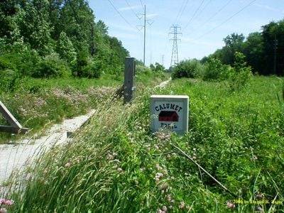
Calumet Trail, National Recreation Trail in Porter County, United States.

Calumet Trail is a hiking path near Lake Michigan that extends about 9 miles through Indiana's dune region and runs on a wide crushed limestone surface. The path runs alongside Route 12 and a rail line, and it connects several nature reserves together.

The path was established in 1976 as Indiana's first bicycle route and was originally paved with asphalt. In 2001 the surface was replaced with limestone to reduce wear and make the ground easier to walk on.

The trail connects two major protected areas and is used by locals and visitors to explore the dune landscape and wildlife. People walk, jog, and cycle here to move through nature and enjoy quietness away from roads.

The path is flat and well-maintained, making it accessible for walkers, joggers, and cyclists of all skill levels. There are several entry and exit points along the route to make access easy and create connections to nearby paths.

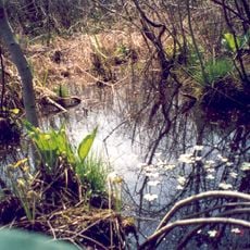
The path passes through wetlands where deer, dragonflies, and native plants can be spotted, which are typically not seen in heavily used areas. This wildlife is especially active during warmer months when the vegetation is fullest.

The community of curious travelers

AroundUs brings together thousands of curated places, local tips, and hidden gems, enriched daily by 60,000 contributors worldwide.

Start exploring
Location
GPS coordinates
41.63930,-87.07940
Latest update
December 14, 2025 11:03
Around this place
Indiana Dunes State Park
United States of America

Indiana Dunes State Park

4 km
Florida Tropical House
United States of America

Florida Tropical House

8.2 km
House of Tomorrow
United States of America

House of Tomorrow

8.2 km
United States of America

Mammals of the Indiana Dunes

2.6 km
Century of Progress Architectural District
United States of America

Century of Progress Architectural District

8.2 km
Cowles Bog
United States of America

Cowles Bog

1.1 km
Josephus Wolf House
United States of America

Josephus Wolf House

12.7 km
Joseph Bailly Homestead
United States of America

Joseph Bailly Homestead

2.2 km
Armco-Ferro House
United States of America

Armco-Ferro House

8.2 km
Wieboldt-Rostone House
United States of America

Wieboldt-Rostone House

8.1 km
Cypress Log Cabin
United States of America

Cypress Log Cabin

8.3 km
Heron Rookery
United States of America

Heron Rookery

10.7 km
George Brown Mansion
United States of America

George Brown Mansion

4 km
Imre and Maria Horner House
United States of America

Imre and Maria Horner House

10.2 km
Bartlett Real Estate Office
United States of America

Bartlett Real Estate Office

8.6 km
Chesterton Commercial Historic District
United States of America

Chesterton Commercial Historic District

3.9 km
Norris and Harriet Coambs Lustron House
United States of America

Norris and Harriet Coambs Lustron House

4 km
Dr. John and Gerda Meyer House
United States of America

Dr. John and Gerda Meyer House

7.7 km
Chesterton Residential Historic District
United States of America

Chesterton Residential Historic District

4 km
Read Dunes House
United States of America

Read Dunes House

2.7 km
Weller House
United States of America

Weller House

11.3 km
Good Fellow Club Youth Camp
United States of America

Good Fellow Club Youth Camp

2.3 km
Solomon Enclave
United States of America

Solomon Enclave

11.8 km
Martin Young House
United States of America

Martin Young House

4 km
Dune Acres Clubhouse
United States of America

Dune Acres Clubhouse

1.6 km
Porter Town Hall
United States of America

Porter Town Hall

2.6 km
Indiana Dunes Visitor Center
United States of America

Indiana Dunes Visitor Center

2.2 km
Crisman Road Bridge
United States of America

Crisman Road Bridge

8.4 km
Show the full map
« Calumet Trail - National Recreation Trail in Porter County, United States » is provided by Around Us (aroundus.com). Images and texts are derived from Wikimedia project under a Creative Commons license. You are allowed to copy, distribute, and modify copies of this page, under the conditions set by the license, as long as this note is clearly visible.

Discover hidden gems everywhere you go!

From secret cafés to breathtaking viewpoints, skip the crowded tourist spots and find places that match your style. Our app makes it easy with voice search, smart filtering, route optimization, and insider tips from travelers worldwide. Download now for the complete mobile experience.

Around Us App Screenshot

A unique approach to discovering new places

Le Figaro

All the places worth exploring

France Info

A tailor-made excursion in just a few clicks

20 Minutes

Around Us
Travel Guide & Maps
Download

Send to your phone

QR Code
1

Open the camera app on your mobile.

2

Point at the QR code with your camera. A notification will appear.

3

Tap the notification to open the link.