Enable Location

We need your location to show you interesting places around you

Discover nearby places

Find interesting locations and hidden gems around you

Precise directions

Get accurate directions and distances to places

Your location is never shared with other users. It's only used when you tap the location button.

Marble Hill Nuclear Power Plant

Log in to your account

Start exploring — it's free

Trusted by 68,131 travelers worldwide

Continue with Google
Continue with Apple
or

We will send you a code to connect

By continuing, you accept our Terms and Conditions and our Privacy Policy

Check your inbox

We've sent a pincode in your inbox. Please enter the code below.

Marble Hill Nuclear Power Plant
Discussion Reviews 1 Photos
17.9k Popularity

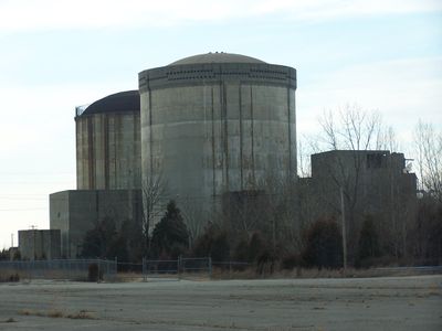
Marble Hill Nuclear Power Plant, former unfinished nuclear power plant in Jefferson County, Indiana

Marble Hill Nuclear Power Plant is an unfinished nuclear power facility in Indiana along the Ohio River designed to house two reactors generating over 2,000 megawatts of power. Today it is marked by concrete foundations, empty towers, and remaining structures after construction stopped in 1984, with most buildings demolished since the early 2000s.

Construction began in 1977 under Public Service Company of Indiana with plans to invest 2.8 billion dollars in the facility. After the Three Mile Island accident in 1979, safety concerns intensified, and combined with rising costs and construction delays, work was abandoned in 1984.

The name Marble Hill comes from the limestone beneath the site, which reminded early settlers of white marble from Italy. This connection to geology and pioneer heritage shaped how the local community understood and named the landscape where industry would later arrive.

The site covers nearly 1,000 acres along the Ohio River and is today mostly empty with demolished structures scattered across the landscape. Access is restricted and safety concerns mean the site is not freely accessible to the public without permission.

At peak construction, about 8,000 workers labored on site, yet a former employee revealed that concrete with air pockets had been used, which would have compromised safety if the plant operated. These quality defects contributed to delays and undermined confidence in the entire project.

The community of curious travelers

AroundUs brings together thousands of curated places, local tips, and hidden gems, enriched daily by 60,000 contributors worldwide.

Start exploring
Location
GPS coordinates
38.60090,-85.44590
Latest update
February 17, 2026 00:20
Around this place
Clifty Falls State Park
United States of America

Clifty Falls State Park

16.6 km
Rose Island
United States of America

Rose Island

24.2 km
Charlestown State Park
United States of America

Charlestown State Park

24.9 km
Lanier Mansion
United States of America

Lanier Mansion

15.8 km
Milton-Madison Bridge
United States of America

Milton-Madison Bridge

15.6 km
United States of America

New Albany Shale

24.7 km
Madison Historic District
United States of America

Madison Historic District

16.8 km
D. W. Griffith House
United States of America

D. W. Griffith House

22.1 km
John Work House and Mill Site
United States of America

John Work House and Mill Site

20.5 km
Charles L. Shrewsbury House
United States of America

Charles L. Shrewsbury House

15.9 km
Schofield House
United States of America

Schofield House

16 km
Rob Morris Home
United States of America

Rob Morris Home

22.4 km
Thomas Downs House
United States of America

Thomas Downs House

25.5 km
Jefferson County Jail
United States of America

Jefferson County Jail

16.2 km
Mathias Wolf Farm
United States of America

Mathias Wolf Farm

21.5 km
Gen. William O. Butler House
United States of America

Gen. William O. Butler House

25.2 km
Thomas A. Hendricks Library
United States of America

Thomas A. Hendricks Library

12.5 km
Hunter's Bottom Historic District
United States of America

Hunter's Bottom Historic District

19.1 km
Lemuel Allen Farm
United States of America

Lemuel Allen Farm

20.8 km
Crawford-Whitehead-Ross House
United States of America

Crawford-Whitehead-Ross House

16.1 km
Carrollton Historic District
United States of America

Carrollton Historic District

24.9 km
Crowe-Garritt House
United States of America

Crowe-Garritt House

12.9 km
Central La Grange Historic District
United States of America

Central La Grange Historic District

22.3 km
Coleman House
United States of America

Coleman House

11.1 km
William L. Coleman House
United States of America

William L. Coleman House

14.2 km
Bates House
United States of America

Bates House

9.7 km
McMahan House
United States of America

McMahan House

22.4 km
House on KY 1492
United States of America

House on KY 1492

14.1 km
Show the full map
Reviews
Share your experience

No review yet

Discussions
Start a discussion...

No discussion yet

« Marble Hill Nuclear Power Plant - former unfinished nuclear power plant in Jefferson County, Indiana » is provided by Around Us (aroundus.com). Images and texts are derived from Wikimedia project under a Creative Commons license. You are allowed to copy, distribute, and modify copies of this page, under the conditions set by the license, as long as this note is clearly visible.

Discover hidden gems everywhere you go!

From secret cafés to breathtaking viewpoints, skip the crowded tourist spots and find places that match your style. Our app makes it easy with voice search, smart filtering, route optimization, and insider tips from travelers worldwide. Download now for the complete mobile experience.

Around Us App Screenshot

A unique approach to discovering new places

Le Figaro

All the places worth exploring

France Info

A tailor-made excursion in just a few clicks

20 Minutes

Around Us
Travel Guide & Maps
Download

Send to your phone

QR Code
1

Open the camera app on your mobile.

2

Point at the QR code with your camera. A notification will appear.

3

Tap the notification to open the link.