·

Enable Location

We need your location to show you interesting places around you

Discover nearby places

Find interesting locations and hidden gems around you

Precise directions

Get accurate directions and distances to places

Your location is never shared with other users. It's only used when you tap the location button.

Teeple Barn

Log in to your account

Start exploring — it's free

Trusted by 62,675 travelers worldwide

Continue with Google
Continue with Apple
or

We will send you a code to connect

By continuing, you accept our Terms and Conditions and our Privacy Policy

Check your inbox

We've sent a pincode in your inbox. Please enter the code below.

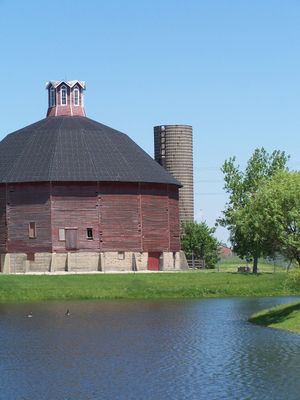
Teeple Barn, historic structure in the USA

Teeple Barn was a round structure with sixteen sides, built in 1885 by architect W. W. Abell for a dairy farmer. Standing over 85 feet tall and roughly the same in width, it featured a brick floor on a foundation of fieldstone and concrete.

Built in 1885 after the original octagonal plan proved impractical, the sixteen-sided design was chosen instead. It was added to the National Register of Historic Places in 1979, remaining one of Illinois' rare round barns until a storm destroyed it in May 2007.

The barn's name comes from the Teeple family who worked the land for over a century. Its round shape was an unusual choice for farming buildings of that era, showing how farmers tried new approaches to improve their daily work.

The site is open to the public year-round with no formal tours required. Located near Randall Road close to the I-90 Tollway, it is easily accessible by car for visitors exploring the area.

The original plan called for an octagonal barn, but available wood lengths forced a sixteen-sided design instead. In 1996, a non-profit group called AgTech raised over 300,000 dollars to restore it before the 2007 storm destroyed the structure.

The community of curious travelers

AroundUs brings together thousands of curated places, local tips, and hidden gems, enriched daily by 60,000 contributors worldwide.

Start exploring
Location
GPS coordinates
42.07750,-88.33500
Latest update
February 9, 2026 07:40
Around this place
Santa's Village AZoosment Park
United States of America

Santa's Village AZoosment Park

6.4 km
Elgin Tower Building
United States of America

Elgin Tower Building

6 km
Elgin National Watch Company Observatory
United States of America

Elgin National Watch Company Observatory

7.3 km
Oaklawn Farm
United States of America

Oaklawn Farm

15.1 km
Dundee Township Historic District
United States of America

Dundee Township Historic District

5.2 km
Elgin Area Historical Society
United States of America

Elgin Area Historical Society

6.3 km
First Universalist Church
United States of America

First Universalist Church

6.5 km
Elgin Historic District
United States of America

Elgin Historic District

6.8 km
Fire Barn 5
United States of America

Fire Barn 5

7.9 km
Wing Park Golf Course
United States of America

Wing Park Golf Course

4.2 km
Ora Pelton House
United States of America

Ora Pelton House

6.8 km
St. Mary's Church of Gilberts
United States of America

St. Mary's Church of Gilberts

4.6 km
Grigsby Estate
United States of America

Grigsby Estate

16.7 km
Memorial Washington Reformed Presbyterian Church
United States of America

Memorial Washington Reformed Presbyterian Church

4.9 km
Christian Geister House
United States of America

Christian Geister House

10.3 km
Larkin Home for Children
United States of America

Larkin Home for Children

5.1 km
Gifford-Davidson House
United States of America

Gifford-Davidson House

6.8 km
Sunderlage Farm Smokehouse
United States of America

Sunderlage Farm Smokehouse

17.7 km
Durant House
United States of America

Durant House

16.8 km
Campton Town Hall
United States of America

Campton Town Hall

18 km
Spring–Douglas Historic District
United States of America

Spring–Douglas Historic District

5.1 km
Wayne Village Historic District
United States of America

Wayne Village Historic District

15.9 km
Robert and Elizabeth Muirhead House
United States of America

Robert and Elizabeth Muirhead House

10.6 km
Andrew Weisel House
United States of America

Andrew Weisel House

18 km
Joel H. Hubbard House
United States of America

Joel H. Hubbard House

18 km
Laura Davidson Sears Academy of Fine Art
United States of America

Laura Davidson Sears Academy of Fine Art

6.2 km
Library Hall
United States of America

Library Hall

5.3 km
Old Elgin High School
United States of America

Old Elgin High School

6.6 km
Show the full map
« Teeple Barn - historic structure in the USA » is provided by Around Us (aroundus.com). Images and texts are derived from Wikimedia project under a Creative Commons license. You are allowed to copy, distribute, and modify copies of this page, under the conditions set by the license, as long as this note is clearly visible.

Discover hidden gems everywhere you go!

From secret cafés to breathtaking viewpoints, skip the crowded tourist spots and find places that match your style. Our app makes it easy with voice search, smart filtering, route optimization, and insider tips from travelers worldwide. Download now for the complete mobile experience.

Around Us App Screenshot

A unique approach to discovering new places

Le Figaro

All the places worth exploring

France Info

A tailor-made excursion in just a few clicks

20 Minutes

Around Us
Travel Guide & Maps
Download

Send to your phone

QR Code
1

Open the camera app on your mobile.

2

Point at the QR code with your camera. A notification will appear.

3

Tap the notification to open the link.