Enable Location

We need your location to show you interesting places around you

Discover nearby places

Find interesting locations and hidden gems around you

Precise directions

Get accurate directions and distances to places

Your location is never shared with other users. It's only used when you tap the location button.

Ludlam's Beach Light

Log in to your account

Start exploring — it's free

Trusted by 61,666 travelers worldwide

Continue with Google
Continue with Apple
or

We will send you a code to connect

By continuing, you accept our Terms and Conditions and our Privacy Policy

Check your inbox

We've sent a pincode in your inbox. Please enter the code below.

Ludlam's Beach Light

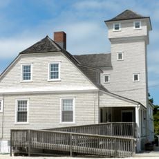
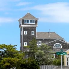
Ludlam's Beach Light, Maritime navigation lighthouse in Sea Isle City, New Jersey

Description

Ludlam's Beach Light is a maritime navigation lighthouse that once stood in Sea Isle City along the New Jersey coast. The two-story structure featured a square tower that produced flashing white signals every 15 seconds from a height of 36 feet (11 meters).

History

The lighthouse was built after Congress approved funding in 1884, with operations beginning on November 3, 1885 under keeper Joshua H. Reeves. Following a fire in 1923 and serious structural deterioration, it was decommissioned in 1924 and replaced by a steel skeletal tower.

Culture

The lighthouse served as a response to numerous shipwrecks near Townsend's Inlet, marking an unlit section of the New Jersey coastline for maritime safety.

Practical

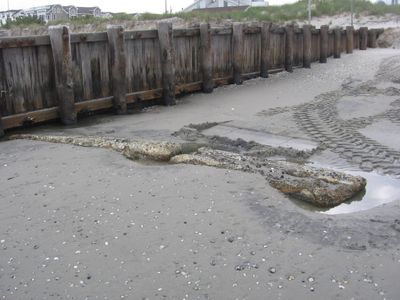
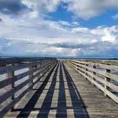
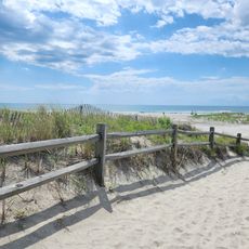
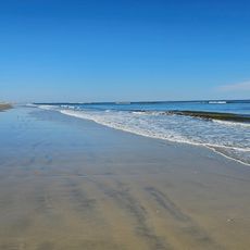
The site is located in Sea Isle City and can be accessed from the beaches, particularly around 31st Street. Visitors should be prepared for changing coastal conditions since what remains of the structure may be visible or buried depending on weather and wave action.

Did you know?

The foundations of the original lighthouse periodically emerge from beneath the sand at 31st Street beach following major coastal storms. These temporarily exposed remains offer a tangible connection to the maritime history buried along this stretch of shore.

Location
Inception
1885
GPS coordinates
39.15980,-74.68810
Latest update
December 14, 2025 18:08

AroundUs brings together thousands of curated places, local tips, and hidden gems, enriched daily by 60,000 contributors worldwide. Discover all places nearby (Cape May County).

Around this place
Cape May County Park & Zoo
United States of America

Cape May County Park & Zoo

12.7 km
Beesley's Point Bridge
United States of America

Beesley's Point Bridge

15.7 km
Cape May National Wildlife Refuge
United States of America

Cape May National Wildlife Refuge

11.8 km
Corson's Inlet State Park
United States of America

Corson's Inlet State Park

7.3 km
Stone Harbor Bird Sanctuary
United States of America

Stone Harbor Bird Sanctuary

14.9 km
John Holmes House
United States of America

John Holmes House

12.9 km
Leaming's Run Gardens
United States of America

Leaming's Run Gardens

7.1 km
Old Cape May County Courthouse Building
United States of America

Old Cape May County Courthouse Building

14.5 km
Woodbine Brotherhood Synagogue
United States of America

Woodbine Brotherhood Synagogue

14.3 km
Henry Ludlam House
United States of America

Henry Ludlam House

13.8 km
Thomas Beesley Sr. House
United States of America

Thomas Beesley Sr. House

14.3 km
U.S. Life-Saving Station No. 35
United States of America

U.S. Life-Saving Station No. 35

15.1 km
William S. Townsend House
United States of America

William S. Townsend House

13 km
Avalon Life Saving Station
United States of America

Avalon Life Saving Station

6.6 km
Calvary Baptist Church
United States of America

Calvary Baptist Church

4.7 km
John Wesley Gandy House
United States of America

John Wesley Gandy House

8.4 km
Thomas Leaming House
United States of America

Thomas Leaming House

7.1 km
Thomas Beesley Jr. House
United States of America

Thomas Beesley Jr. House

12.8 km
Joseph Falkinburg House
United States of America

Joseph Falkinburg House

11.5 km
South Tuckahoe Historic District
United States of America

South Tuckahoe Historic District

15.4 km
Thomas Ludlam Jr. House
United States of America

Thomas Ludlam Jr. House

11.9 km
Reeves-Iszard-Godfey House
United States of America

Reeves-Iszard-Godfey House

4.6 km
Sunset Pier
United States of America

Sunset Pier

4.3 km
New Asbury Methodist Episcopal Meetinghouse
United States of America

New Asbury Methodist Episcopal Meetinghouse

7.3 km
Beesley's Point Beach
United States of America

Beesley's Point Beach

15.2 km
Whale Beach
United States of America

Whale Beach

3.9 km
Ludlam Beach
United States of America

Ludlam Beach

1.5 km
Seven Mile Beach
United States of America

Seven Mile Beach

10.6 km
Show the full map
« Ludlam's Beach Light - Maritime navigation lighthouse in Sea Isle City, New Jersey » is provided by Around Us (aroundus.com). Images and texts are derived from Wikimedia project under a Creative Commons license. You are allowed to copy, distribute, and modify copies of this page, under the conditions set by the license, as long as this note is clearly visible.

Discover hidden gems everywhere you go!

From secret cafés to breathtaking viewpoints, skip the crowded tourist spots and find places that match your style. Our app makes it easy with voice search, smart filtering, route optimization, and insider tips from travelers worldwide. Download now for the complete mobile experience.

Around Us App Screenshot

A unique approach to discovering new places

Le Figaro

All the places worth exploring

France Info

A tailor-made excursion in just a few clicks

20 Minutes

Around Us
Travel Guide & Maps
Download

Send to your phone

QR Code
1

Open the camera app on your mobile.

2

Point at the QR code with your camera. A notification will appear.

3

Tap the notification to open the link.