Enable Location

We need your location to show you interesting places around you

Discover nearby places

Find interesting locations and hidden gems around you

Precise directions

Get accurate directions and distances to places

Your location is never shared with other users. It's only used when you tap the location button.

Carns State Aid Bridge

Log in to your account

Start exploring — it's free

Trusted by 61,319 travelers worldwide

Continue with Google
Continue with Apple
or

We will send you a code to connect

By continuing, you accept our Terms and Conditions and our Privacy Policy

Check your inbox

We've sent a pincode in your inbox. Please enter the code below.

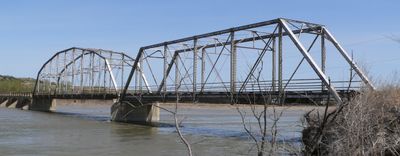
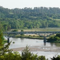
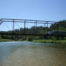
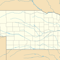
Carns State Aid Bridge, Steel bridge in Rock County, Nebraska

Description

Carns State Aid Bridge is a steel structure that crosses the Niobrara River using a Parker and Pratt through truss design. The bridge was built with steel and concrete to connect communities on both sides of the river.

History

The bridge was built in 1912 by Lincoln Construction Company and became essential for connecting rural communities. It marked a turning point in the early development of Nebraska's transportation network.

Culture

The structure represents a milestone in American civil engineering, demonstrating the technical capabilities and architectural preferences of early twentieth-century bridge construction methods.

Practical

The bridge is located about 11 miles northeast of Bassett and is accessible to both vehicles and pedestrians. The surrounding area is good for fishing and watching wildlife.

Did you know?

The bridge spans less than one acre and received its National Register of Historic Places designation in 1992 under reference number 92000722.

Location
GPS coordinates
42.73360,-99.48110
Latest update
December 14, 2025 18:46

AroundUs brings together thousands of curated places, local tips, and hidden gems, enriched daily by 60,000 contributors worldwide. Discover all places nearby (Nebraska).

Around this place
Smith Falls
United States of America

Smith Falls

70.3 km
Niobrara National Scenic River
United States of America

Niobrara National Scenic River

70.3 km
Fort Niobrara National Wildlife Refuge
United States of America

Fort Niobrara National Wildlife Refuge

80.6 km
Snake Creek Recreation Area
United States of America

Snake Creek Recreation Area

78.8 km
Niobrara Valley Preserve
United States of America

Niobrara Valley Preserve

45 km
United States of America

White Horse Ranch

37.9 km
Bryan Bridge
United States of America

Bryan Bridge

86.2 km
Brewer Bridge
United States of America

Brewer Bridge

66 km
Bell Bridge
United States of America

Bell Bridge

71 km
St. Augustine Church
United States of America

St. Augustine Church

56 km
Cherry County Courthouse
United States of America

Cherry County Courthouse

88.8 km
Valentine Public School
United States of America

Valentine Public School

88.5 km
Lewis Bridge
United States of America

Lewis Bridge

32 km
St. John's Catholic Church
United States of America

St. John's Catholic Church

37.9 km
Borman Bridge
United States of America

Borman Bridge

86 km
Tripp County Veteran's Memorial
United States of America

Tripp County Veteran's Memorial

77.7 km
Berry State Aid Bridge
United States of America

Berry State Aid Bridge

74.3 km
Herrick Elevator
United States of America

Herrick Elevator

49.8 km
Rouse Ranch
United States of America

Rouse Ranch

72.3 km
Church of Christ in LaRoche Township
United States of America

Church of Christ in LaRoche Township

86.7 km
Brantly Sturdevant House
United States of America

Brantly Sturdevant House

47.1 km
Dallas Carnegie Library
United States of America

Dallas Carnegie Library

56 km
Holt County Courthouse
United States of America

Holt County Courthouse

74.9 km
Old Nebraska State Bank Building
United States of America

Old Nebraska State Bank Building

75 km
Rock County Courthouse
United States of America

Rock County Courthouse

17.4 km
Manthey Barn
United States of America

Manthey Barn

58.7 km
Distrito electoral de Valentine (condado de Cherry, Nebraska)
United States of America

Distrito electoral de Valentine (condado de Cherry, Nebraska)

86.7 km
Smith Falls State Park
United States of America

Smith Falls State Park

70.5 km
Show the full map
« Carns State Aid Bridge - Steel bridge in Rock County, Nebraska » is provided by Around Us (aroundus.com). Images and texts are derived from Wikimedia project under a Creative Commons license. You are allowed to copy, distribute, and modify copies of this page, under the conditions set by the license, as long as this note is clearly visible.

Discover hidden gems everywhere you go!

From secret cafés to breathtaking viewpoints, skip the crowded tourist spots and find places that match your style. Our app makes it easy with voice search, smart filtering, route optimization, and insider tips from travelers worldwide. Download now for the complete mobile experience.

Around Us App Screenshot

A unique approach to discovering new places

Le Figaro

All the places worth exploring

France Info

A tailor-made excursion in just a few clicks

20 Minutes

Around Us
Travel Guide & Maps
Download

Send to your phone

QR Code
1

Open the camera app on your mobile.

2

Point at the QR code with your camera. A notification will appear.

3

Tap the notification to open the link.