Enable Location

We need your location to show you interesting places around you

Discover nearby places

Find interesting locations and hidden gems around you

Precise directions

Get accurate directions and distances to places

Your location is never shared with other users. It's only used when you tap the location button.

Brewer Bridge

Log in to your account

Start exploring — it's free

Trusted by 61,319 travelers worldwide

Continue with Google
Continue with Apple
or

We will send you a code to connect

By continuing, you accept our Terms and Conditions and our Privacy Policy

Check your inbox

We've sent a pincode in your inbox. Please enter the code below.

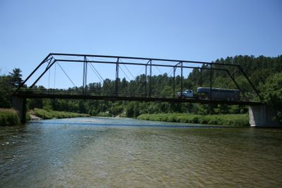
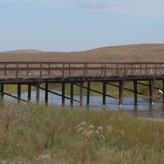
Brewer Bridge, Historical bridge in Cherry County, United States

Description

Brewer Bridge is a road crossing over the Niobrara River in Cherry County, Nebraska. It uses a Pratt through truss design made of steel and remains in use for vehicle traffic today.

History

The bridge was constructed in 1899 by the Wrought Iron Bridge Company of Canton, Ohio. It replaced an earlier structure called the Berry Bridge at the same location.

Culture

The bridge represents early American engineering methods and stands as a testament to the development of transportation infrastructure in rural Nebraska communities.

Practical

You can walk onto Brewer Bridge and enjoy open views of the river and the surrounding landscape. Visit during daytime to see the steel framework and structural details clearly.

Did you know?

This structure was one of only four bridges in Cherry County to survive the destructive ice flood of 1916. This rare resilience makes it a notable example of durable construction in the region.

Location
GPS coordinates
42.87610,-100.26600
Latest update
December 14, 2025 18:20

AroundUs brings together thousands of curated places, local tips, and hidden gems, enriched daily by 60,000 contributors worldwide. Discover all places nearby (Cherry County).

Around this place
Smith Falls
United States of America

Smith Falls

4.3 km
Niobrara National Scenic River
United States of America

Niobrara National Scenic River

4.2 km
Valentine National Wildlife Refuge
United States of America

Valentine National Wildlife Refuge

49.4 km
Fort Niobrara National Wildlife Refuge
United States of America

Fort Niobrara National Wildlife Refuge

14.8 km
St. Francis Mission
United States of America

St. Francis Mission

64.5 km
Niobrara Valley Preserve
United States of America

Niobrara Valley Preserve

22 km
United States of America

White Horse Ranch

98.4 km
Bryan Bridge
United States of America

Bryan Bridge

21.9 km
Carns State Aid Bridge
United States of America

Carns State Aid Bridge

66 km
Bell Bridge
United States of America

Bell Bridge

5 km
St. Augustine Church
United States of America

St. Augustine Church

72.9 km
Cherry County Courthouse
United States of America

Cherry County Courthouse

23.3 km
Valentine Public School
United States of America

Valentine Public School

22.9 km
Lewis Bridge
United States of America

Lewis Bridge

53.1 km
Adamson Bridge
United States of America

Adamson Bridge

34 km
St. John's Catholic Church
United States of America

St. John's Catholic Church

62.2 km
Borman Bridge
United States of America

Borman Bridge

21 km
Twin Bridge
United States of America

Twin Bridge

72.8 km
Tripp County Veteran's Memorial
United States of America

Tripp County Veteran's Memorial

64.9 km
Berry State Aid Bridge
United States of America

Berry State Aid Bridge

8.3 km
Herrick Elevator
United States of America

Herrick Elevator

92.4 km
F.M. Walcott House
United States of America

F.M. Walcott House

23.5 km
Spotted Tail Gravesite
United States of America

Spotted Tail Gravesite

62.7 km
Dallas Carnegie Library
United States of America

Dallas Carnegie Library

72.9 km
Rock County Courthouse
United States of America

Rock County Courthouse

68.1 km
Manthey Barn
United States of America

Manthey Barn

54.5 km
Distrito electoral de Valentine (condado de Cherry, Nebraska)
United States of America

Distrito electoral de Valentine (condado de Cherry, Nebraska)

21.6 km
Smith Falls State Park
United States of America

Smith Falls State Park

4.5 km
Show the full map
« Brewer Bridge - Historical bridge in Cherry County, United States » is provided by Around Us (aroundus.com). Images and texts are derived from Wikimedia project under a Creative Commons license. You are allowed to copy, distribute, and modify copies of this page, under the conditions set by the license, as long as this note is clearly visible.

Discover hidden gems everywhere you go!

From secret cafés to breathtaking viewpoints, skip the crowded tourist spots and find places that match your style. Our app makes it easy with voice search, smart filtering, route optimization, and insider tips from travelers worldwide. Download now for the complete mobile experience.

Around Us App Screenshot

A unique approach to discovering new places

Le Figaro

All the places worth exploring

France Info

A tailor-made excursion in just a few clicks

20 Minutes

Around Us
Travel Guide & Maps
Download

Send to your phone

QR Code
1

Open the camera app on your mobile.

2

Point at the QR code with your camera. A notification will appear.

3

Tap the notification to open the link.